Country:
 City:
City:


Park in the Chimay car park, on Rue de Marigny, by the castle gate in the village of Ménars.
(S/E) Leave the car park and turn left onto Avenue Marquise de Pompadour (D2152). Turn left onto Rue des Grèves, then left again onto Ruelle de La Pataude. At the end of the lane, turn right onto Rue André Rouballay. Follow this street, then turn left onto Rue Princesse Bibesco. Walk past the cemetery and continue along Chemin des Bates (a grassy path) alongside the railway line. After 600 metres, the path turns left to join the D2152. Cross the road carefully as there is heavy traffic, then continue straight ahead.
(1) Turn right onto Chemin des Masures. After 150 metres, turn left then right. Follow the path to Rue des Grèves, then turn left onto it. At the next junction, marked with a cross, turn left onto Rue de la Croix. Turn right onto Rue des Perce-Neige and follow it to the footpath on the Loire embankment.
(2) Take the footpath on the right and follow it to a car park.
(3) Turn right towards the village of Saint-Denis-sur-Loire along a street lined with plane trees.
(4) Walk alongside the river Les Mées. Pass the gate of the Château de Saint-Denis and continue to the steps on Rue de Bellevue on the left. Go up the steps and follow Rue de Bellevue, which becomes Rue Bernard Lorjou (after the painter) after a bend to the right. Turn right onto Rue de l’Église. You’ll find yourself opposite the church.
(5) Turn left into Rue de la Loire. Pass Chemin de Pissevin on your left and, a little further on, take a footpath on the left. Walk alongside the sports grounds and take the first street on the left, which leads back onto Chemin de Pissevin. Turn right onto this path and continue until you reach the junction with Rue Charlotte Guilbert.
(6) Carry on straight ahead along the Chemin de Pissevin. Continue to the junction with Rue du Vieux Moulin.
(7) Turn left here; at the end of the bend, veer right onto Rue de la Borde. Very soon, take the small dirt track on the right. It ends in a tarmac road leading to Rue Muraton. Turn right onto this street (house with a turret and a pretty door on the left) and head back down to the junction with Rue du Vieux Moulin, which you passed earlier.
(7) Turn left to rejoin the previous route and head back to the junction with Rue Charlotte Guilbert.
(6) Walk a few steps and turn into the lane on the right. Turn left straight away to walk alongside the garden fence. Shortly afterwards, the path crosses the fields to join Rue du 8 Mai 1945. At the end of the street, turn right onto Rue Bernard Lorjou, then take thefirst left onto Rue de l’Église, which brings you back to the front of the church at Saint-Denis-sur-Loire.
(5) Turn right and walk back down to the Loire.
(3) Take the footpath along the Loire embankment again to reach the junction you passed on the way out.
(2) Turn right onto the path leading to the banks of the Loire and follow it to the entrance gate to the grounds of Ménars Castle.
(8) Continue along the Loire embankment towards Cour-sur-Loire, with the castle’s surrounding wall on your left. You’ll reach the far end of the castle at a junction where there are three stone markers.
(9) Carry on along the embankment until you reach the barrier blocking vehicle access.
(10) Stay along the banks of the Loire, with the church and château on your left, until you reach Rue du Port.
(11) Turn left onto this street; it is a small, pink-paved street. At the end of the street, turn right onto Rue Robert de Flers. At the first junction, turn left onto Rue de la Mairie. Continue to the end of this street until you reach Rue de la Loire.
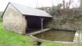
(12) Turn right onto Rue de la Loire. A little further on, on the left, there is a pretty square with a covered fountain and a drinking fountain. Continue along the same street to reach the banks of the Loire. Follow the path along the banks of the Loire back towards Ménars. Carry on until you reach the crossroads with the three stone markers you passed earlier.
(9) Turn left down the small path. Walk alongside the Loire; a little further on, you’ll catch a glimpse of Ménars Castle over the park wall. Continue to the junction by the entrance gate to the grounds of Ménars Castle.
(8) Turn left onto Rue de la Loire to reach the Chimay car park (S/E).

 Visorando Member

 Easy
Easy