


Verte Gaume, starting from Gennevaux


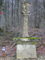
Here in winter, the meadows and fields are green! This lovely, undulating region with its varied landscapes is perfect for walking. On this side, there are no visible mining remains such as those located a little further south, straddling the Franco-Belgian border… apart, of course, from the reminders of this industrial past provided by the Corten steel signposts: a brilliant idea which also makes it fairly easy to find your way around, provided, of course, that you know the region a little and the names of the various localities. The walk does, however, pass by a cross (a protected heritage site in Wallonia) dating from the Napoleonic era. And occasionally, you come across strange works of art as you wander along the path.
Details
–
-
 Activity: Walking
-
 Distance: 8.61 mi
-
 Average duration: 4h 30
-
 Difficulty: Moderate
-
-
 Back to start: Yes
-
 Ascent: + 636 ft
-
 Descent: - 656 ft
-
-
 Highest point: 1,142 ft
-
 Lowest point: 797 ft
-
 Country:
Belgium
-
 Area: Massif des Ardennes
-
 City:
Musson
-
 Start/End: N 49.569476° / E 5.700131°
-
 IGN map(s): Ref. 3210E
-


 Hour-by-hour weather


Photos
Waypoints
- S/E : mi 0 - alt. 843 ft - Gennevaux bus stop – Route de Willancourt
- 1 : mi 0.81 - alt. 984 ft - Cross – bench
- 2 : mi 1.34 - alt. 1,040 ft - Entrance to the forest
- 3 : mi 2.12 - alt. 1,099 ft - Fork in the road
- 4 : mi 2.59 - alt. 951 ft - Le Relais
- 5 : mi 3.82 - alt. 1,007 ft - Picnic table
- 6 : mi 4.86 - alt. 899 ft - Work of art
- 7 : mi 4.89 - alt. 899 ft - Rachecourt – Football Pitch
- 8 : mi 5.3 - alt. 1,102 ft - Le Bochet
- 9 : mi 5.64 - alt. 1,125 ft - Baudrichtal
- 10 : mi 6.29 - alt. 1,086 ft - Cross – bench
- 11 : mi 6.94 - alt. 1,047 ft - Local place name ‘Le Pertot’ – bench
- 12 : mi 7.53 - alt. 991 ft - N800
- S/E : mi 8.61 - alt. 843 ft - Gennevaux bus stop – Route de Willancourt
Other walks in the area
The gentle and peaceful Gaume region from Willancourt
 Visorando Member
 11.16 mi
+974 ft
-974 ft
6h 00
Moderate
 Departure from Aubange (Province de Luxembourg)
In the footsteps of the iron miners
 11.60 mi
+1,585 ft
-1,568 ft
6h 45
Moderate
Departure from Musson (Province de Luxembourg)
Gaume circular between Rachecourt and Battincourt
 8.87 mi
+961 ft
-984 ft
4h 55
Moderate
Departure from Aubange (Province de Luxembourg)
Halanzy – Habay-la-Neuve
 14.09 mi
+991 ft
-568 ft
7h 20
 Difficult
Departure from Aubange (Province de Luxembourg)
Le Trou du Beau Bois
6.48 mi
+397 ft
-390 ft
3h 20
Moderate
Departure from Aubange (Province de Luxembourg)
In the Gaume Natural Park
 7.17 mi
+568 ft
-581 ft
3h 50
Moderate
Departure from Saint-Léger (Belgique) (Province de Luxembourg)
Along the Chiers between Lexy and Cons-la-Grandville
 6.30 mi
+433 ft
-456 ft
3h 15
Moderate
Departure from Lexy (Meurthe-et-Moselle)
Mining heritage in Lasauvage and Fond-de-Gras
 13.12 mi
+1,142 ft
-1,135 ft
7h 00
Difficult
Departure from Differdange (Luxembourg (Country))
For more walks, use our search engine .
The GPS track and description are the property of this route's author. Please do not copy them without permission.

