


 Country:
 City:
City:


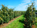
Overall, Oupeye is highly urbanised, but the agricultural and fruit-growing area around Heure-le-Romain has many old quarries and lots of paths suitable for hiking.
As the region is hilly, the walk offers some beautiful views of the surrounding area, particularly in the distance over the Meuse valley and the slag heaps of the old coal mines.
If possible, it is best to take this walk when the fruit trees are in bloom in spring or when they are bearing fruit in late summer.
Orchards and vineyards in Oupeye


The centuries-old cultivation of countless cherry, pear and apple trees has earned Oupeye the title of Walloon Commune of Fruit Growing.
Although the few hectares of vineyards are more recent, the wine produced in Heure-le-Romain is gradually improving in quality and regularly wins awards.
Details
Creation:
Last update:
Last review:
–
–
-
 Activity: Walking
 -
 Distance: 10.16 mi
 -
 Average duration: 5h 10
 -
 Difficulty: Moderate
 -
-
 Back to start: Yes
 -
 Ascent: + 617 ft
 -
 Descent: - 600 ft
 -
-
 Highest point: 492 ft
 -
 Lowest point: 226 ft
Photos
Description of the walk
Waypoints
- S/E : mi 0 - alt. 335 ft - Church of Heure-le-Romain
- 1 : mi 0.2 - alt. 302 ft - Rue de la Crayère
- 2 : mi 1.56 - alt. 289 ft - Crossroads
- 3 : mi 2.25 - alt. 400 ft - Amry
- 4 : mi 2.76 - alt. 249 ft - Grand-Aaz stream
- 5 : mi 3.11 - alt. 236 ft - Beaurieux stream
- 6 : mi 3.98 - alt. 335 ft - Beaurieux
- 7 : mi 5.36 - alt. 289 ft - Brou Bara
- 8 : mi 5.84 - alt. 407 ft - Fragnay
- 9 : mi 6.92 - alt. 387 ft - Grand Aaz
- 10 : mi 8.11 - alt. 476 ft - Crossroads
- 11 : mi 8.88 - alt. 410 ft - Rue de Houtain
- 12 : mi 9.66 - alt. 400 ft - Rue Boyou
- S/E : mi 10.16 - alt. 335 ft - Church of Heure-le-Romain
Notes
There are a few parking spaces at the starting point.
Other walks in the area
Geer Valley starting from Houtain-Saint-Siméon
 Visorando Member
 6.90 mi
+446 ft
-463 ft
3h 35
Moderate
6.90 mi
+446 ft
-463 ft
3h 35
Moderate
 Departure from Oupeye (Province de Liège)
A pleasant and varied walk on the plateau and around the Geer valley. Starting from the small village of Houtain-Saint-Siméon, the route joins that of Heure-le-Romain, following tree-lined paths to reach Les Hauts de Froidmont and returning through the undergrowth on the southern slope of the Geer valley. The route passes several former quarries, now converted into nature reserves.
Les Hauts de Froidmont, starting from Houtain-Saint-Siméon
 10.25 mi
+610 ft
-614 ft
5h 15
Moderate
Departure from Oupeye (Province de Liège)
10.25 mi
+610 ft
-614 ft
5h 15
Moderate
Departure from Oupeye (Province de Liège)
A varied countryside walk leading to the Hauts de Froidmont, passing through fields and tree-lined paths to reach the Geer and follow the valley floor as far as Wonck. The route runs alongside several chalk, marl and silica quarries, some of which have been abandoned and are currently being replanted, and passes several nature reserves.
Route suggested by the walking club “Les Pantouflards de Wihogne” (FFBMP, LG041).
Abreu and Beaurieux circular
1.91 mi
+89 ft
-89 ft
0h 55
 Easy
Departure from Oupeye (Province de Liège)
Easy
Departure from Oupeye (Province de Liège)
Departure from the Pêcherie du Fer à Cheval in Heure-le-Romain. There is a large car park available.Set off on this lovely walk of about 1 hour through fields and streams. It is fairly easy and mostly flat. Why not take your dog for a walk before coming to quench your thirst on our terrace by the water?
The epicurean walk in Oupeye
4.28 mi
+259 ft
-259 ft
2h 10
Easy
Departure from Oupeye (Province de Liège)
Set off on this lovely walk, between fields and streams, which is fairly easy and mostly flat, with a few small ascents and descents.Why not take your dog for a walk before coming to quench your thirst or enjoy a meal on our terrace by the water?
Houtain-Saint-Siméon and the Geer Valley
 6.58 mi
+361 ft
-361 ft
3h 20
Moderate
Departure from Oupeye (Province de Liège)
6.58 mi
+361 ft
-361 ft
3h 20
Moderate
Departure from Oupeye (Province de Liège)
The last village to the west of the Hesbaye plateau and therefore surrounded by fields, Houtain-Saint-Siméon is also ideally situated for exploring the routes of the Geer Valley. This route ventures into the valley twice, following shaded paths and sunken lanes.
Walk suggested by the walking club "Les Pantouflards de Wihogne" (FFBMP, LG041).
A tour of the vineyards between Oupeye and Heure-Le-Romain
4.54 mi
+322 ft
-308 ft
2h 20
Easy
Departure from Oupeye (Province de Liège)
Walk organised by the Rotary Club Liège Ville Mosane and the Rotary Club Liège Rive Droite. Starting from the Trois Rois vineyard, passing by the Moulin de Grenade and the Vin de Liège winery, exploring the vineyards of the Trois Rois estate.
Oupeye – Haneffe
 18.89 mi
+272 ft
-210 ft
8h 55
18.89 mi
+272 ft
-210 ft
8h 55
 Difficult
Departure from Oupeye (Province de Liège)
Difficult
Departure from Oupeye (Province de Liège)
Travelling from Oupeye, in the north of the Liège region, to Haneffe and its farmland is no easy feat, given the city’s expansion, the numerous motorways and their tangled junctions, not to mention Bierset Airport. And yes, this29th stage takes this route – or rather, these detours – to offer a journey mainly through the countryside along small country roads. A magical ride not to be missed.
A circular walk starting from Fexhe-Slins
 9.68 mi
+604 ft
-607 ft
5h 00
Moderate
Departure from Juprelle (Province de Liège)
9.68 mi
+604 ft
-607 ft
5h 00
Moderate
Departure from Juprelle (Province de Liège)
On the edge of Hesbaye, vast fields still make up the bulk of the landscape. This walk, however, takes you along a few tree-lined paths and through wooded valleys, and also allows you to discover a typical (and listed) limestone meadow that has developed following the reclamation of a former quarry.
Walk organised by the walking club “Les Pantouflards de Wihogne” (FFBMP, LG041)
For more walks, use our search engine .
The GPS track and description are the property of this route's author. Please do not copy them without permission.

