Country:

 City:
City:


Start from the main square in Autrans.
(S/E) From the main square in Autrans, head west along the Chemin du Manoir, a pedestrian street. Yellow-red markings. Continue until you reach the Carrefour de la Tour.
(1) Turn right towards Route de Nave. Yellow-red signposting, in open country. Stay on this wide path after crossing the Route de Nave until you reach a crossroads in the woods.
(2) Then turn left towards Pas de Pierre Taillée.
Walk past the Auberge du Banc de l’Ours and continue for 200 metres.
(3) At the next crossroads, turn right towards Gève. Cross the tarmac road. Continue straight on along a path towards Pas de Montbrand. Do not take the parallel path signposted ‘Private property’.
Join the white-and-redGR® markings and continue due north until you reach the Font Renard fountain and drinking trough.
(4) Font Renard fountain. Stay on the white-and-red markings, which turn left at a 90° angle. Cross a forest track. Continue following the markings.
(5) Leave the white-and-red markings for a path that climbs to the left, signposted: Pas de Montbrand. Yellow-and-green markings.
(6) Pas de Montbrand. Cross the gap and descend on the other side, heading towards Fessole. A vertiginous descent; best avoided in wet weather. The yellow-green markings become scarce. Follow the signposts towards Fessole. You’ll rejoin a wide track.
(7) At this path, turn right uphill, following the sparse yellow-green markings. Walk along a wide, almost flat path through the forest.
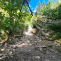
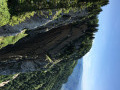
(8) Halfway along, take in the view of the sheer drop at the Pas de Montbrand (photo). Continue along this good path, climbing gently up a valley. You’ll reach the Ferme de Fessole.
(9) Walk round the superbly secluded Ferme de Fessole, keeping it on your right. Behind the farm, take a path that climbs diagonally across the meadow and then into the forest, heading towards Pas de Pierre Taillée.
(10) Pas de Pierre Taillée. Head downhill, following the yellow-green markings, which are now more frequent.
(11) Join the white-and-redGR® markings on a wide forest track. Turn left onto it, heading towards: Signal de Nave. Stay on the white-and-red markings.
(12) Signal de Nave. Stay on the white-and-red markings, heading towards: La Cheminée.
(13) At the signpost for ‘la Cheminée’, turn right towards ‘Gève’. A few metres further on, turn right again, heading due south, onto a faintly marked path towards ‘Autrans’. Yellow-green markings. Continue straight ahead down a gentle slope.
(14) Carry on in a straight line, heading due south. Join another path and follow it straight on. Continue until you reach another fork.
(15) Signpost: Le Haut du Canyon. About a hundred metres further on, carry on straight ahead, whilst the track turns to the left.
(16) Cross a forest track. Carry on straight ahead.
(17) At the crossroads, marked by plot numbers (in red) 169, V and IX, turn right at a right angle onto a wide forest track. Follow it for 250 m.
(18) At plot numbers 169 and 170, join a forest track. Turn left onto it, heading downhill. 50 m further on, cut through the woodland to the right to reach a sunken path hidden below. At a fork in the road, turn right (yellow-green markings). Continue to the 1246-metre mark, following a bend to the right.
(19) After this wide right-hand bend, you’ll see a white boundary stone marked (on the reverse) with ‘2G1’. Turn 90° to the left, heading south-west, onto a little-used path that descends straight down the slope.
(20) The path becomes a tarmac road; follow it straight ahead. After a left-hand bend, cross another road and continue straight on. At the end, head down the D 106 to the right, towards Autrans Church, which is visible in the distance (S/E).

 Visorando Member
 Easy
Easy 
 Moderate