Along an old railway line north of Lannion

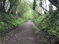
Apart from a short stretch through the north-eastern districts of Lannion, this route follows the route of an old railway line that linked Lannion to Perros-Guirec. It is therefore not particularly difficult but allows you to walk through areas where nature has reclaimed its territory.

Details

n°531529
Creation:
Last update:
Last review:
  • Walking
    Activity: Walking
  • ↔
    Distance: 7.49 mi
  • ◔
    Average duration: 3h 45 
  • ▲
    Difficulty: Moderate

  • ⚐
    Back to start: Yes
  • ↗
    Ascent: + 397 ft
  • ↘
    Descent: - 400 ft

  • ▲
    Highest point: 348 ft
  • ▼
    Lowest point: 43 ft
  • ⚐ Country: France
  • ⚐ City: Lannion (22300)
  • ⚑
    Start/End: N 48.730613° / W 3.442317°
  • ❏
    IGN map(s): Ref. 0714OT
  • Hour-by-hour weather

Description of the walk

Park Nevez swimming pool car park.

(S/E) Leave the car park to the left via Rue Madeleine. At the roundabout, continue straight ahead, then turn left into Rue Théodore Botrel. Follow Rue Saint-Marc to the left until you reach the roundabout. Take the path on the right which runs alongside Boulevard Lafayette and, at the Fork in the road, turn right.

(1) Continue to the right, following the Pen ar Biez stream. Pass under the county road.

(2) At the crossroads, turn right. Ignore the path on the left, cross the stream and turn left immediately. A little further on, cross the stream again to reach the junction with theGR®34and 34A links.

(3) Turn right towards the north. Continue in this direction. Cross one road, then asecond after turning north-east. Continue straight ahead. The path leads onto another road as you approach the high-voltage power lines.
Cross the road and continue straight ahead. Pass under the power lines and walk a few metres.

(4) Turn right, leaving theGR®. At the T-junction, turn left and, at the next junction, take the left-hand hairpin bend. You rejoin theGR® at the junction with a road on the right. Carry on straight ahead.

(5) At the hamlet of Lan ar Moudet, turn left and then left again at the end of the hamlet. Follow the road as it bends to the right.

(4) Follow the outbound route in the opposite direction.

(3) Keep to the left.

(2) Turn left to rejoin the GR®.

(1) At the Fork in the road, turn right to continue alongside the stream. Cross the boulevard and carry on straight ahead.

(6) At the crossroads, turn right to cross the stream and, immediately afterwards, turn left.

(7) When the path becomes a street, turn left and do a U-turn to cross the stream again and reach a path on the right leading to Rue de Breiz Izel.

(8) Follow it to the left for about fifty metres, then turn left onto Rue de Pen ar Briez and follow it for about thirty metres. Walk round the buildings, keeping them on your right, until you reach the Saint-Marc roundabout. Go south at the roundabout and join Rue Charles Gerhardt.

(9) Before the next roundabout, cross the road and turn left into Rue des Cordiers. Cross a car park on the right, walk alongside the buildings at the side of the road and you’ll reach the car park where you started (S/E).

Waypoints

  1. S/E : mi 0 - alt. 157 ft - Park Nevez car park
  2. 1 : mi 0.63 - alt. 82 ft - Junction for the return journey
  3. 2 : mi 0.92 - alt. 118 ft - Crossroads
  4. 3 : mi 1.28 - alt. 141 ft - Junction with the GR routes
  5. 4 : mi 2.8 - alt. 341 ft - Start and end of the circular loop
  6. 5 : mi 3.64 - alt. 338 ft - On the left, temporarily leave the GR
  7. 6 : mi 6.29 - alt. 59 ft - On the right, on the other bank
  8. 7 : mi 6.57 - alt. 46 ft - Street, turn round to the left
  9. 8 : mi 6.95 - alt. 105 ft - Street on the left
  10. 9 : mi 7.27 - alt. 141 ft - Crossing Rue Charles Gerhardt
  11. S/E : mi 7.49 - alt. 157 ft - Park Nevez car park

Notes

(3) On the return journey, you can continue straight on, following theGR®. Further on, you’ll reach the junction you passed by on the way out. In this case, at the end of the path in (2), go straight on.

Always be cautious and plan ahead when you're outdoors. Visorando and the author of this route cannot be held responsible for any accidents occurring on this route.

The GR® and PR® markings are the intellectual property of the Fédération Française de Randonnée Pédestre.

Reviews and comments

3.8 / 5
Based on 2 reviews

Reliability of the description
4.5 / 5
Ease of following the route
4.5 / 5
Route interest
2.5 / 5
Valbil
Valbil

Overall rating : 4 / 5

Date of your route : Mar 30, 2026
Reliability of the description : ★★★★★ Very good
Ease of following the route : ★★★★☆ Good
Route interest : ★★★☆☆ Average
Very busy route : Yes

Nice

Machine-translated

Marie Annick Guillaume

Overall rating : 3.7 / 5

Date of your route : Jul 31, 2023
Reliability of the description : ★★★★☆ Good
Ease of following the route : ★★★★★ Very good
Route interest : ★★☆☆☆ Disappointing
Very busy route : No

The Émile Orain Route, a former railway line.
Very well signposted,
I preferred the section through the woods, where I did the circular route; otherwise, there’s nothing much to see along the route.

Machine-translated

Other walks in the area

For more walks, use our search engine .

The GPS track and description are the property of this route's author. Please do not copy them without permission.