Country:

 City:
City:


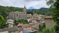
Car park at the entrance to the village, on Route de Malval, just before the church, coming from the Col de Malval.
(S/E) Follow the road towards the village for about ten metres, then take the steps on your right which lead you past the church. Walk down the street which leads down to the village’s main road (D50) and turn right towards the town hall.
(1) Turn left onto the narrow path that climbs to the right of the municipal library. This pleasant path climbs above the village and continues along a lovely balcony.
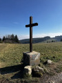
(2) At the first junction, continue to your left through some light woodland, then keep to the right at the fork that appears just after. The path leads to a major crossroads with a beautiful cross.
(3) Take the road leading uphill on your left. After the farm on your left, the road turns into a dirt track and leads straight on to a pass.
(4) Follow the path which climbs across the fields to your right. Pass some greenhouses on your right and reach a three-way junction.
(5) Take the path leading down to your left towards some more large greenhouses and a farm. Walk past the farm to come out onto the tarmac road leading down towards Courzieu. Join the road ahead of you and continue to the hairpin bend.
(6) Leave the road here and take the dirt track branching off to the left, which joins theGRP® after about 200 m. Follow it to your left, climbing through the forest to reach the Col de la Croix de Pars.
(7) Leave theGRP® and take the fairly wide dirt track that branches off to your left and enters the forest. After 250 m, ignore the path that climbs up to your right and stay on the dirt track, which descends steeply through the coniferous forest and eventually leads to a ruined hut.
(8) At this point, follow the path leading down to the right. This will take you to the hamlet of Biternay.
(9) Take the road leading down to the right of the hamlet. Leave this road at a water catchment basin and follow the path leading straight ahead through the undergrowth, which is often quite damp. You’ll reach a beautiful farm overlooking the Courzieu valley.
(10) Turn left to go round the farm and follow the stony track until you reach a right-hand bend. At this point, take the path leading off to the left. This lovely path, paved with large slabs, descends through magnificent beech trees before turning into a pleasant balcony-style path. Ignore any side paths you come across (often created by mountain bikes). After walking alongside some meadows, you’ll reach a crossroads with an orientation board.
(11) Head down the steep, partly concrete path on your left towards the hamlet of Lafont. Follow the road leading downhill opposite you, slightly to the right.
(12) Before the last house, take the path that branches off to the right of it and leads through meadows. After a fairly steep descent, the path arrives in a hamlet and joins a road. Leave this road immediately to follow a narrow path that descends to the right, between two houses: the one on the right has an external staircase with railings. This very steep path leads down to the village of Courzieu. When you reach Chemin de la Croix Rousse, turn right to quickly come out onto Route de Malval. Then turn left to return to the car park (S/E).


 Visorando Member

 Easy
Easy