On the heights of Pouzin

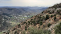
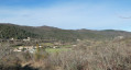
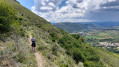
This walk offers breathtaking views of the Rhône and Drôme rivers and the villages of Pouzin, Baix, Meysse and Rochemaure. There are lovely views of the Trois Becs as well as the Crest keep, the tallest in France.

Details

35186145
Creation:
Last update:
Last review:
  • Walking
    Activity: Walking
  • ↔
    Distance: 13.67 mi
  • ◔
    Average duration: 8h 50 
  • ▲
    Difficulty: Difficult

  • ⚐
    Back to start: Yes
  • ↗
    Ascent: + 2,890 ft
  • ↘
    Descent: - 2,894 ft

  • ▲
    Highest point: 1,713 ft
  • ▼
    Lowest point: 295 ft

Description of the walk

Park in front of Pouzin Town Hall, 3 Avenue Marcel Nicolas.

(S/E) Opposite, take Rue Vincent d’Indy to the end and continue along Rue Olivier de Serre.

(1) Turn left onto Chemin de Rompon, which climbs steeply. Follow the white and red markings ofthe GR®42. Continue uphill until you reach the crossroads at the Couvent des Chèvres.

(2) Turn right onto the path marked in white and yellow to reach the convent shortly.

(3) Retrace your steps to return to the previous crossroads.

(2) Turn right back onto theGR® and follow it to reach the hamlet of Vieux Rompon.

(4) Continue straight ahead down the slope, go round a gate and, at the bottom of the slope, you’ll reach a chapel.

(5) Turn right to start the climb again and you’ll reach a multi-way junction in the village of Le Four.

(6) Continue straight ahead on theGR® and enter the forest to reach the hamlet of Chalos.

(7) Carry on climbing and then begin a series of hairpin bends. After a fairly long and difficult climb, you’ll reach the Tallans lodge as you emerge from the forest.

(8) Carry on and you’ll immediately come to a T-junction. Leave theGR® here, turn left and follow the D265a. Pass through the hamlet of Bastier and carry on straight ahead to reach a crossroads in a clearing.

(9) Leave the D265a and turn left to begin a gentle descent. At thefirst junction, turn left onto the path through the woods. Cross the Ravin des Grangettes and continue to the right at the next junction to reach La Branche.

(10) Turn left onto the path and you’ll reach another crossroads. Keep to the right and, after two hairpin bends, you’ll reach a road at a hairpin bend at the Ravin de la Branche.

(11) Turn right onto it; at the next bend, leave the road and turn left onto a path. Carry on, passing through the hamlet of La Garde. Turn left onto the road to reach, after a bend, the place known as Cordier.

(12) Carry on downhill along the path on the right. Further on, cross the Ruisseau des Blaches. Then, at the next crossroads, take the left-hand branch to reach the hamlet of Champeyrache.

(13) Carry on straight ahead, due south, along the road. Pass Les Cheynes, then walk past the cemetery and emerge at La Barnaude onto the D104.

(14) Take care here: take the road on the left and leave it on the right a few hundred metres further on, at the Teinture buildings. Cross the Ouvèze and head for Travers des Celliers.

(15) Turn slightly to the right and continue uphill along the road. Pass Saint-Alban, then, via a wide left-hand bend, reach a three-way junction at the Col de Linte, where the route joins theGR®42.

(16) Take the path straight ahead and follow it to complete the climb to the Serre du Gouvernement.

(17) Continue to the right, downhill; this is still theGR®. At the various crossroads, stay on theGR® and head into the forest near the climbing site and Maison Vinson.

(18) Walk alongside the forest, then turn right into it and complete the descent to the Pouzin bridge. Cross the Ouvèze via this bridge and head towards the town hall car park on the opposite side (S/E).

Waypoints

  1. S/E : mi 0 - alt. 302 ft - Pouzin Town Hall car park
  2. 1 : mi 0.37 - alt. 305 ft - Rompon Path
  3. 2 : mi 1.02 - alt. 974 ft - Couvent des Chèvres junction
  4. 3 : mi 1.25 - alt. 948 ft - Le Couvent des Chèvres
  5. 4 : mi 2.21 - alt. 1,060 ft - Old Rompon
  6. 5 : mi 2.38 - alt. 1,010 ft - Chapelle du Prédicant
  7. 6 : mi 2.89 - alt. 627 ft - Le Four
  8. 7 : mi 3.2 - alt. 732 ft - Chalos
  9. 8 : mi 4.7 - alt. 1,604 ft - Tallans lodge
  10. 9 : mi 5.71 - alt. 1,699 ft - D265a junction
  11. 10 : mi 6.54 - alt. 1,572 ft - The Branch
  12. 11 : mi 7.12 - alt. 1,260 ft - Branche Gorge
  13. 12 : mi 8.44 - alt. 725 ft - Cordier
  14. 13 : mi 9.22 - alt. 591 ft - Champeyrache
  15. 14 : mi 9.9 - alt. 410 ft - La Barnaude D104
  16. 15 : mi 10.35 - alt. 387 ft - Travers des Celliers
  17. 16 : mi 11.09 - alt. 932 ft - Col de Linte (282m)
  18. 17 : mi 11.96 - alt. 1,142 ft - Serre du Gouvernement
  19. 18 : mi 12.87 - alt. 938 ft - Edge of the woodland
  20. S/E : mi 13.67 - alt. 302 ft - Pouzin Town Hall car park

Worth a visit

(3) Visit the ruins of the Couvent des Chèvres.
Between (15) and (16) are the ruins of Saint-Alban Castle.
Please note: for safety reasons, both sites are protected by barriers and access is prohibited.

Always be cautious and plan ahead when you're outdoors. Visorando and the author of this route cannot be held responsible for any accidents occurring on this route.

The GR® and PR® markings are the intellectual property of the Fédération Française de Randonnée Pédestre.

Reviews and comments

4 / 5
Based on 3 reviews

Reliability of the description
3.7 / 5
Ease of following the route
3.7 / 5
Route interest
4.7 / 5
papa
papa

Overall rating : 4.3 / 5

Date of your route : Mar 24, 2026
Reliability of the description : ★★★★☆ Good
Ease of following the route : ★★★★☆ Good
Route interest : ★★★★★ Very good
Very busy route : No

A lovely walk. We lost our way between point 10 and point 11. Following the GPS, we strayed a bit from the path.
The climb at the end of the walk after the detour to St Julien en St Alban is quite tiring, and the descent to Pouzin at the end of the walk is quite steep and uneven. After a long distance, your legs will feel heavy, so please take care.

Machine-translated

MICHEL PETIT
MICHEL PETIT

Overall rating : 3.3 / 5

Date of your route : Sep 18, 2024
Reliability of the description : ★★★☆☆ Average
Ease of following the route : ★★★☆☆ Average
Route interest : ★★★★☆ Good
Very busy route : No

A lovely walk completed in 5 hours 40 minutes. Watch out for the steep slope that catches you off guard between points 12 and 13; likewise, the climb after point 15 is a bit of a slog towards the end of the walk. Finally, be careful on the descent before reaching LE POUZIN, as it can be quite steep at times. There are a few navigation difficulties between points 10 and 11, where the path disappears completely – you’ll have to navigate by feel – and between points 12 and 13 as you follow the stream back up.

Machine-translated

befre
befre

Overall rating : 4.3 / 5

Date of your route : Oct 04, 2023
Reliability of the description : ★★★★☆ Good
Ease of following the route : ★★★★☆ Good
Route interest : ★★★★★ Very good
Very busy route : No

Alternative route: after 1, at the first fork, turn right towards “Couvent des chèvres” and head straight to 3 (a magnificent climb), then continue towards 2 and then 4.
Problem between 10 and 11: when the route on the map turns sharply to the right
(you leave a path branching off to the left, and straight ahead there is a path leading downwards, which you must not take), our path is no longer visible; you must follow the GPS through the woods for about 200 metres to rejoin a well-marked path.

A magnificent walk, suitable only for experienced walkers.

Machine-translated

Other walks in the area

For more walks, use our search engine .

The GPS track and description are the property of this route's author. Please do not copy them without permission.