Country:

 City:
City:


(S/E) Starting from the car park at Place de l’Église in Buhl, with your back to the fountain, turn right opposite onto Rue du Schrangen. Continue along the track. Ignore a path on the left and carry on uphill until you reach the next track.
(1) Cut across to the Schrangen Pass on a path marked with a Red Triangle. Reach the Schrangen Pass. There is a shelter at the pass.
(2) Carry on straight ahead, heading west, following the Yellow Triangle markings. Keep left at the junction, then turn right onto a winding path. Once you reach a wider track, turn left and you’ll come to a Fork in the road with the Blue Triangle path.
(3) Carry on straight ahead, then take the second path on the left towards the Hohrupf. At the junction, turn right, then left onto a path leading to the summit of the Hohrupf.
(4) From the Hohrupf, retrace your steps to the junction with the Blue Triangle-marked trail.
(3) Head down to the right along this winding path, crossing two forest tracks. As you approach Murbach, admire the Chapel of Our Lady of Loreto, a Baroque sanctuary dating from 1693 and modelled on the Santa Casa de Loreto.
(5) Continue along the winding path downwards and turn right onto the road. From the abbey, head back up the valley to the next junction.
(6) Head back down the D40II to take the footbridge on the right spanning the Murbach Stream, marked with a Blue Disc. Cross a track and arrive at the junction with the Red Triangle-marked path leading to the Saint-Barnabé Bridge. Keep left at this junction. Continue along the track and carry on straight ahead to the bridge.
(7) Just downstream of this bridge, turn right onto the path marked with a Yellow Disc, which passes via the Hochkopf. Keep left at the Fork in the road, then carry on straight ahead. At the next junction, keep left, then left again until you come to a path on the right.
(8) Take this path. At the forest track, first turn right then left. Cut across a path and another track to reach the pass. Ignore the path leading to the summit and continue down the slope opposite until you reach the track. Follow it to the right until you reach the path marked with a Red Disc.
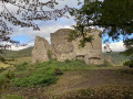
(9) Follow this path downwards to the left and continue straight ahead until you reach Hugstein Castle (on the left as you descend).
(10) From the château, take the Blue Triangle-marked path on the left towards Buhl. Continue for a few metres along the road, then turn right onto Rue de la Tuilerie. Turn left, then left again at the roundabout onto Rue du Florival until you reach the bend. Turn left onto Rue de l’Eglise (a slight climb) and continue straight ahead to return to the starting point. (S/E)


 Visorando Member
 Easy
Easy 
 Tourist office
 Association / Club / Walk leader