


 Country:

 City:
City:


The starting point of the walk is the Schauinslandbahn mountain station.
(S/E) The route leads downhill from the mountain station to the car park. From there, climb the short flight of steps to the left
to turn right onto the tarmac road towards Halde (signposted ‘Rotlache’, blue diamond on a white background). After an uphill stretch, follow the large sign (blue diamond on a white background – Section 1): a meadow path runs along the right-hand edge of the forest. Over the next few kilometres, you can enjoy unobstructed views across Hofsgrund and towards the highest peaks of the Black Forest, the Feldberg and the Belchen. The meadow path turns into a bumpy, gently sloping track which joins the pass road after 500 metres.
(1) Below this road, follow the path straight on towards Halde (signposted ‘Sailenmatte’ – blue diamond on a white background).
(2) After one kilometre, the path crosses a tarmac road (road sign for Flammweg, connection to Hofsgrund). Cross this and turn left onto the path, which once again runs below the pass road
. On a hot summer’s day, you’ll be glad to reach the small wood that follows – the path
continues straight ahead through it.
(3) After a further 500 metres alongside pastures, the path meets Silberbergstraße (further road links
to Hofsgrund). Opposite, you can already see the entrance to the Hotel Die Halde (blue diamond on a white background). This is a great spot to take your first culinary break.
(4) The route then continues in the same direction to a chapel, which is situated immediately after the
hotel on the right-hand side. Passing this, a small, steep meadow path climbs to the right up to the road. Cross the road and walk across the meadows into the adjacent copse. The path joins a wider hiking trail. Walk slightly uphill to the left here (blue diamond on a white background). From here, you’ll have a sweeping view across the edge of the Black Forest, stretching as far as the Rhine Valley and the Vosges. The path winds downhill in a wide arc. At the next junction, turn right towards Zähringer Hof. Follow this sign straight ahead.
(5) The path now curves and leads straight towards the farm. A cool drink or a tasty meal is already waiting for you in the on-site restaurant. The path continues through the farmyard before turning sharply right after 100 metres (black arrow). The path continues through the pasture, offering a view of the farm from above.
(6) At the next junction, turn left and walk straight ahead along the Panoramaweg through meadows and pastures.
(7) After 1.2 km, this path joins a tarmac road leading into the Münster Valley. Cross this
and continue along the path opposite on the other side (yellow diamond on a white background). The farm track winds its way up the slope.
(8) After 500 m, you’ll pass a farm on your left and continue straight ahead. Passing the farms that follow, take the short side road to the right and up onto the country lane (yellow diamond on a white background). Follow this as it climbs to the left.
(9) After the car park, the path branches off to the right (arrow pointing towards Farnacker; blue diamond on a white background, heading towards the slag heap). Once again, the route runs between pastures and meadows, offering fresh views! You’ll pass through another farmstead.
(10) The path winds its way uphill towards the next farmstead with its striking wind turbine (yellow diamond on a white background – yellow round signs). Go through a wooden door, past the farmstead, towards the mountain pass road. Once you have crossed this, you will rejoin the walking trail described at the start; turn left here and follow it in reverse order (signpost ‘Überm Pochenlift’ – blue diamond on a white background).
(S/E) After a gentle 1.4 km climb, you’ll reach your destination. The Café & Restaurant Die Bergstation is the perfect place to round off the walk.


 Visorando Member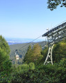

 Very difficult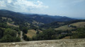
 Association / Club / Walk leader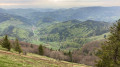
 Difficult
