Country:

 City:
City:


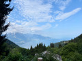
Start from the free car park along the Route des Monts in Caux (access to the Haut-de-Caux car park is not always permitted).
(S/E) Head north-east and follow the Chemin de Cerniaz uphill.
(1) Turn right onto the Chemin du Tremplin (Via Alpina).
(2) You’ll come out onto the Route de Jaman; follow it to the right to reach the Haut-de-Caux car park.
(3) Then turn left.
(4) At the first Fork in the road, keep to the right and follow the sign for the Rochers de Naye along the mountain path, on the Route des Raveyres. Pass the Haut-de-Caux station on your left. Ignore a few turn-offs to the right and arrive at Liboson d’en Haut.
(5) Continue south then south-west along a path climbing through the forest to the next junction.
(6) At the paragliding take-off area, take a path that climbs to the left, still heading towards the Rochers de Naye. Keep heading north-east and go round a rocky outcrop (Les Dentaux) on the right.
(7) At the fork in the road at a place called Sautodoz, turn right towards the Rochers de Naye. Continue climbing and pass under a small bridge.
(8) The train’s terminus and its restaurant are on your left. You can turn right to visit the alpine garden. Retrace your steps. Cross the small bridge and go round the restaurant on the left. After a few hairpin bends, you’ll reach the summit of the Rochers de Naye (with a bird’s-eye view of Lake Geneva).
(9) Head right towards the north-east, pass a cross and follow the long ridge of the Chaux de Ney (the route is exposed on the left-hand side; take great care).
(10) At the signpost, take a path leading down to the left towards the MGN Jaman ski resort (narrow and steep path: take care; section equipped with chains). Continue along a series of steps on the cliff face, then onto a path crossing a scree slope. This will take you to the Col de Bonaudon.
(11) Carry on straight ahead (west) towards Jaman ski resort. Descend along a narrow path.
(12) At a fork in the road, turn right and head back up to the Jaman station.
(13) Cross the railway line with care and continue north. Climb up to the signpost.
(14) There are two options here:
- Climb the Dent de Jaman (I only made it halfway up; it’s a very steep climb, verging on rock climbing in places). I came back down to take a faint path on the right, completing a circular route to avoid the very steep descent, and returned to the point (14).
- Alternatively, continue the climb to the cross.
- Or don’t climb the Dent de Jaman and take the path on the left, which is at an acute angle, and head down south-south-west towards Caux.
(15) At the junction, first turn right then left to continue descending towards Caux.
(16) At a place called Chamossale, carry on straight ahead along the descending path, passing the farm on your left. Further on, ignore a path coming from the right and continue down the slope.
(17) At the next junction, turn left and follow the winding path downwards. This will take you to Crêt-d’y-Bau station.
(18) Cross the tracks with care and continue downwards, keeping the railway line on your left. You’ll reach Haut-de-Caux station, which you passed earlier in the walk.
(4) Continue along the same route (westwards).
(3) At the junction that appears immediately, carry on straight ahead and you’ll soon reach the car park where you started (S/E).
 Visorando Member
 Difficult
 Moderate
 Easy
Easy