Refuge de l’Estrop – La Foux d’Allos

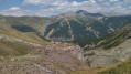
Day2 of this route takes you to the summit of the Estrop, then back down to the Foux d’Allos resort via the Baisse de l’Aiguille. A very technical hike, featuring extensive and exposed scree slopes. The view from the summit is fantastic, taking in the whole of the Champsaur Range, the Écrins, the Queyras and the Mercantour. You’re sure to spot chamois, ibex and marmots. This stage requires sure-footedness.

This walk is part of a multi-day hike: The Tête de l’Estrop over two days

Details

n°24511290
Creation:
Last update:
Last review:
  • Walking
    Activity: Walking
  • ↔
    Distance: 7.71 mi
  • ◔
    Duration according to the author: 7 hrs 
  • ▲
    Difficulty: Very difficult

  • ⚐
    Back to start: No
  • ↗
    Ascent: + 3,517 ft
  • ↘
    Descent: - 4,452 ft

  • ▲
    Highest point: 9,616 ft
  • ▼
    Lowest point: 5,732 ft

Photos

Description of the walk

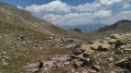
Preliminary note: thefirst part of the route climbs steeply through beautiful pastures, following the cairns, before quickly entering a very rocky landscape. In this landscape, you’ll pass large flat slabs and small rocky outcrops that require a bit of climbing, using your hands and the rocks for support. It is essential to follow the cairns and the yellow markings on the numerous rocks.

(S) Set off from the Refuge de l’Estrop, heading west and following the cairns.
You’ll reach a flat area, in a sort of small valley, with three cairns arranged in a triangle marking the junction of three paths.

(1) Turn left to begin the most difficult part of this route, which marks the start of the ascent of the Estrop. You will soon reach a scree slope with a maze of large boulders; cross it.
Caution: this section requires great care, as some boulders are precariously balanced. In this technical maze, follow the yellow markings closely, checking for them before proceeding.
You’ll reach a sort of pass where a magnificent panorama of the northern slope already opens up before you.
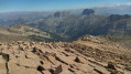
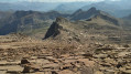
Go slightly round the ridge to reach large rock slabs leading to the summit.
Caution here: this section is very impressive but the rock is not slippery. You will then reach the summit of the Estrop.

(2) Retrace your steps, keeping an eye out for the yellow markings.
However, you must take great care as the descent is even more technical than the ascent, particularly on the scree slope. Make your way to the junction of the three cairns.

(1) Turn left and begin the descent through a landscape that remains very rocky: slabs, boulders, rocky outcrops…
Take a moment here to look around; numerous ibex and chamois inhabit this lunar landscape. At the bottom of the descent, you’ll reach a stream.

(3) Cross it, then veer left and begin a new ascent. Make your way alternately across scree slopes and small pastures until you reach the junction with the path leading up to the Petite Barre.

(4) Turn right onto a slight plateau to reach the Baisse de l’Aiguille.

(5) Turn left and head for the top station of the Observatoire chairlift.

(6) Take the path that descends steeply to the right. Continue across the wide pastures until you come out again at the chairlifts and onto the ski run.

(7) Turn left and follow the wide track to an old ski lift station.

(8) Leave the run to the right onto a path running along a ridge above the resort. Continue to the bottom of the resort and return to the car park at the start of the route at Pont de l’Abrau (E).

Waypoints

  1. S : mi 0 - alt. 6,680 ft
  2. 1 : mi 1.84 - alt. 8,783 ft - Crossroads with 3 cairns
  3. 2 : mi 2.38 - alt. 9,616 ft - Estrop (l')
  4. 3 : mi 3.52 - alt. 8,146 ft - Stream
  5. 4 : mi 4.03 - alt. 8,566 ft - La Petite Barre junction
  6. 5 : mi 4.57 - alt. 8,360 ft - Descent from the Aiguille
  7. 6 : mi 4.72 - alt. 8,438 ft - Upper station of the Observatoire chairlift
  8. 7 : mi 5.84 - alt. 7,211 ft - Below the chairlift
  9. 8 : mi 6.91 - alt. 6,257 ft - Former railway station
  10. E : mi 7.71 - alt. 5,732 ft - Abrau Bridge - Verdon (rivière)

Notes

There are no water sources at this time of year.
High-top walking boots are recommended due to the numerous scree slopes.
You are in the high mountains, so bring warm clothing, even in summer. The weather can change quickly.
Please note: the scree sections are technically challenging and can sometimes be dangerous.

Worth a visit

(2) The Tête de l’Estrop: enjoy a magnificent panorama from here: the Écrins, including the Barre des Écrins, the Vieux Chaillol, the Champsaur and the Montagne de Ceüse, the Ventoux, the Queyras, the Viso and the Mercantour.

Reviews and comments

4.7 / 5
Based on 1 review

Reliability of the description
5 / 5
Ease of following the route
4 / 5
Route interest
5 / 5
Randonneur du dimanche

Overall rating : 4.7 / 5

Date of your route : Jul 06, 2024
Reliability of the description : ★★★★★ Very good
Ease of following the route : ★★★★☆ Good
Route interest : ★★★★★ Very good
Very busy route : No

The hike took place in difficult conditions: rain along part of the route and a large number of snowfields (very unusual at this time of year). In these conditions, yes, the ‘very difficult’ rating is justified (markings obscured by the snowfields and slippery rocks). Perhaps not under ‘normal’ weather conditions for July.
The first 2 km from the refuge immediately set the tone: your heart rate soars.
After that, you’ll need to look for the yellow markings amongst the rocks, and sometimes use your hands.
For me, the snowfields were the main obstacle to making good progress.
I couldn’t see a thing of the summit, which was shrouded in thick fog. A shame
On the way back to La Foux, again because of the snowfields, I navigated using the GPS track (thank you!) but I noticed that this track was sometimes quite a way off the yellow markings (when they were visible). At times I wasn’t sure which to follow: the GPS track or the markings. I went with my gut (a bit of both – sometimes the yellow markings, sometimes the GPS)
I’d checked the weather forecast, but it was a bit too optimistic. That spoiled the fun a bit, but all in all, it was a lovely hike.

Machine-translated

Other walks in the area

For more walks, use our search engine .

The GPS track and description are the property of this route's author. Please do not copy them without permission.