Country:

 City:


Please note: the access road to the starting point is a very, very steep and rather rough track, but it is passable by any vehicle in good working order. Park at the crossroads in the hamlet of Le Caire, marker 175a.
(S/E) Set off north-west along the track and head uphill to reach marker 175b.
(1) Leave the track and take the paved path to the right through the woodland; you will then reach a crossroads with several directions, marked by marker 176.
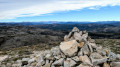
(2) Turn right onto a well-marked path and head for the Puy de Naouri, whose summit is marked by two cairns.
(3) Retrace your steps along this path to return to the crossroads marked by signpost 176.
(2) Continue straight ahead along a barely visible track, then climb up to reach the summit of the Puy des Tourrettes.
(4) Turn left at a 90° angle, head downhill and, at the lowest point, you’ll come to another T-junction, marked by two cairns.
(5) Start climbing again and head towards an information board at the edge of the woodland.
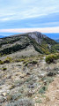
(6) Follow the edge of this woodland to the summit of the Pic des Courmettes.
(7) Head left, then return to the edge of the woodland; keep to the right to reach the junction with the information sign.
(6) Follow the path you took on the way there in the opposite direction and reach the junction with the two cairns.
(5) Head off-track to the right down into the valley alongside the pine trees, following a stream as you go, until you reach the hamlet known as l’Avélanéou.
(8) Keep to the right of the visible track, taking care. At the bottom of the descent, you’ll reach marker 179.
(9) Turn left onto the wide track and, further on, reach a Y-shaped junction of two tracks.
(10) Take the track on the left and follow it to the car park in the hamlet of Le Caire, marker 175a (S/E).
 Visorando Member
 Moderate

 Easy