Country:

 City:
City:


(S/E) Leave the refuge and head towards the dam.
(1) Cross it and continue along the path carved into the rock, which climbs towards the foot of the Lower Litérole Valley.
(2) Turn right onto a narrow track, the start of which is marked by a cairn. Cross the lower part of the valley horizontally, then follow the path which crosses a rocky ridge on the western flank of Pic Royo. This very exposed section must be tackled with great caution and is not suitable for those prone to vertigo.
Continue climbing diagonally south-westwards, heading for the base of a rocky spur, which you should go round to reach the base of the moraine of what remains of the Portillon Glacier.
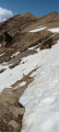
(3) Turn left (east-southeast) to begin the ascent of the Upper Litérole Valley. This involves climbing over scree and boulders, some of which may be unstable. Some snowfields may remain even in summer, and it is best to bypass them. Cairns help guide your progress.
There are several possible routes across the scree slopes: choose the one that seems most accessible to reach the Col Supérieur de Litérole.
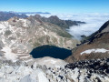
(4) Stop to enjoy the sweeping view down over the beautiful Lac de Litérole on the Spanish side. Then, start the ascent on the right up a 20-metre rocky couloir leading to the ridge. Although this short section does not require any climbing experience, it does demand caution and is not recommended for those who are uncomfortable on exposed terrain or prone to vertigo.
(5) Pic Perdiguère: the highest peak in the Luchonnais region at an altitude of 3,220 metres. Enjoy the exceptional view over the Maladeta–Aneto massif, the Posets, the Pic des Spijeoles – which will be the next day’s destination – and the Pic des Gourgs Blancs. Not to mention the Grand Quayrat, Lézat, Crabioules and Maupas range.
The return journey follows the same route, taking care on the short section of descent leading to the Col Supérieur de Litérole, as well as when crossing the rocky ridge on the western flank of Pic Royo. Head back to the Refuge Jean Arlaud (S/E).

 Visorando Member
 Easy
Easy 
 Moderate
 Difficult
  Association / Club / Walk leader