Country:
 City:
City:



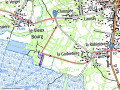
The walk starts from the forecourt of Saint-Pierre Church in Petit-Mars. Parking is available in the immediate vicinity of the church.
(S/E) Walk back up towards the roundabout and turn left. Cross the square diagonally to the right and, at the very end, take the Chemin de Launay. Walk through a residential estate until you see, on your left, an old mill, the Moulin de Launay. The road then turns into a dirt track that descends quite steeply. Follow it until you come to a path.
(1) Turn left onto this track. At the end of a nearly straight stretch, turn right onto the cross-track. This new track curves to the left and comes to a Fork in the road; take the right-hand branch. Continue until you reach Rue de la Hardière.
(2) Cross the street to take Rue du Haut Plessis, opposite. Carry on straight ahead, ignoring the end of Rue du Haut-Plessis which opens out to the left; leave Petit-Mars and take the second street opening out to the left, Allée du Portail de Fer. Turn into the lane and carry on until you come to a path on the left.
(3) Take this path on the left, which ends where it meets Rue du Port. Turn right, then, a few metres further on, turn left onto a path that takes a wide right-hand bend, followed by two right-angled bends – first turn left then right. You’ll come to a crossroads with a path joining from the left.
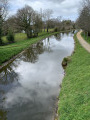
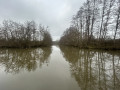
(4) To reach the banks of the Erdre (and back), carry on straight ahead (the path is signposted ‘Port la Rivière 0.7 km’). The path joins a road where you turn right, then left when you reach another road. Once you reach Port de la Rivière, a small path running alongside a channel leads to the banks of the Erdre. What a lovely spot for a picnic!
(5) Retrace your steps and return to the crossroads.
(4) Once back, turn right onto the relatively narrow path, lined all the way with acacia shoots (a fine example of an invasive species!). Join a road and follow it to the left. Turn right at the first path you come to. After two right-angled bends, you’ll arrive at the hamlet of Le Breil.
(6) Carry on straight ahead, then turn into the first street on the left. You’ll arrive in the Vieux Bourg; carry on straight ahead and, after passing through the village (Rue des Marais), you’ll reach a three-way junction.
(7) Turn right, then quickly take the first track on your right. At the end of this, turn left onto Chemin de Cousseau. Follow it until you reach La Guibietière. Turn right onto the second street you come to (Rue du Grand Vivier) to reach a large roundabout at the junction with the D178.
(8) Cross the roundabout carefully and take Rue de la Pommeraie opposite. Follow this road, passing Rue des Varennes on your left, until you reach a point just before a fairly sharp right-hand bend.
(9) Then take the path that opens up on the left and leads straight uphill. This path leads onto Rue des Acacias, where you turn right. When you reach a Fork in the road, take the right-hand path. Continue straight ahead. Just before a right-hand bend that is almost at a right angle, you’ll come to the Grotte de Lourdes on your right, accessible via a small downhill path. Take a look at this local attraction.
(10) Retrace your steps. Opposite you, there are three path entrances; take the first one on the right and you’ll soon reach the Étang du Tertre Rouge. You can take a break here or walk around the lake.
(11) Retrace your steps. In front of you, take the steps leading to the start of a path marked with a Yellow Cross (markings for another walking route). Follow this very pleasant path which goes round a large housing estate (Le Varennes) and leads, after a few bends, to Impasse du Sous-Bois, marked by a small pond. Turn left to reach Rue François Rortais.
(12) Turn left onto this street until you see a roundabout on your left (you can occasionally see the church tower on the left). Turn left twice to return to Saint-Pierre Church (S/E).

 Visorando Member
 Easy
Easy