Pradières d’en haut car park – Étang d’Izourt – Refuge du Fourcat

First stage of the journey through the Haute-Ariège.
A beautiful, steady climb takes you to the Étang d’Izourt, steeped in human history.
This is followed by a gruelling climb up to the Orri de la Caudière.
Once you’ve crossed the rustic footbridge, there’s another very steep climb up to the small Étang du Fourcat.
The rest of the route to the Étang du Fourcat refuge is more gentle.
A very steep climb to the Fourcat refuge with an average gradient of 17 per cent.
Please note: from the Étang d’Izourt to the refuge, the gradient is 24 per cent.

Details

23773323
Creation:
Last update:
Last review:
  • Walking
    Activity: Walking
  • ↔
    Distance: 4.80 mi
  • ◔
    Average duration: 5h 55 
  • ▲
    Difficulty: Difficult

  • ⚐
    Back to start: No
  • ↗
    Ascent: + 4,298 ft
  • ↘
    Descent: - 75 ft

  • ▲
    Highest point: 8,022 ft
  • ▼
    Lowest point: 3,770 ft
  • ⚐ Country: France
  • ⚐
    Area: Pyrenees
  • ⚐ City: Auzat (09220)
  • ⚑
    Start: N 42.717265° / E 1.487785°
  • ⚑
    End: N 42.66493° / E 1.489669°
  • ❏
    IGN map(s): Ref. 2148OT, 2148OTR
  • Hour-by-hour weather

Photos

Description of the walk

From Tarascon-sur-Ariège, head towards Vicdessos via the D8. Then follow the signs for Auzat, staying on the D8. On leaving the village, continue towards Marc, still on the D8. Please note: after 2 km, turn left and head uphill along the hairpin bends towards Artiès, then carry on straight on to Pradières d’en haut. Park 400 m further on in the large, designated car park below on the right.

Please note: there is a risk of confusion with the red and white markings for theGR®10,GR®10Aand GRT64 routes, which you should follow.

White and red markings forthe GR®10.

(S) Continue to the far end of the car park, following the markings and signposts. Cross the footbridges and reach the end of the road leading to the Pradières Power Station. Follow a track for a few metres.

(1) Turn right and head steeply uphill through the forest. The path emerges from the trees and offers some beautiful views. Continue the climb, keeping parallel to the EDF cable car, which is still in operation. You’ll reach the Étang d’Izourt Shepherd’s Hut, reserved for the shepherd during the summer grazing season.
A few information boards explain the rich human history of this place.

(2) Directional signs without details of the variousGR® routes.
Stay on level ground with the dam on your right until the next junction.

Red and white markings forthe GR®10A.

(3) Let the rest of theGR®10branch off to the left. Continue straight on along theGR®10A.

(4) Take care: markings are missing or unclear. No directional signs.
Do not head down towards the Étang d’Izourt. Climb slightly towards the east and ignore a yellow painted sign indicating: Petsiguer.
Stay on the hillside above the pond, heading south. You’ll come across the poorly markedGR®10Atrail again.
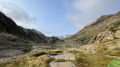
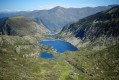
Reach the far end of the pond . Magnificent view due north. A lovely spot for a well-deserved first break.

(5) Continue due south along a path that climbs very steeply up into the mountain pastures. You’ll reach a poorly marked junction, still with no signposting, at the Orri de la Caudière. A second break is possible here.

(6) Take care: there are no markings and the route is confusing.
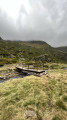
Turn right and immediately cross an old footbridge over the Ruisseau de la Caudière.
The path heads south-west and climbs very steeply once again through the mountain pastures. After a short section with a rope, the route continues over rocky ground. This is where the mountain section begins.
You’ll reach the first Petit Étang Fourcat. Another lovely spot for a break.

(7) Continue to the right of these ponds and climb much more gently towards the clearly visible mountain hut opposite. You’ll reach a poorly marked junction at the 2431-metre mark.

White and red markings for the GRT64 variant.

(8) Turn left, following the old red and white markings.
You’ll arrive at the Étang Fourcat mountain hut at 2,445 m for your first night’s stay (E).

Waypoints

  1. S : mi 0 - alt. 3,770 ft - Pradières d’en haut car park
  2. 1 : mi 0.41 - alt. 3,953 ft - Footbridge – Track – GR10
  3. 2 : mi 1.9 - alt. 5,446 ft - Pastoral Hut at Étang d’Izourt - Étang d'Izourt
  4. 3 : mi 1.96 - alt. 5,489 ft - GR10A – Junction
  5. 4 : mi 2.06 - alt. 5,499 ft - GR10A – Junction
  6. 5 : mi 2.77 - alt. 5,443 ft - Viewpoint over the - Étang d'Izourt
  7. 6 : mi 3.27 - alt. 6,345 ft - Orri de la Caudière. Fork in the path. Footbridge
  8. 7 : mi 4.19 - alt. 7,680 ft - Petit Étang Fourcat
  9. 8 : mi 4.68 - alt. 7,949 ft - GRT64 alternative route
  10. E : mi 4.8 - alt. 8,022 ft - Refuge du Fourcat

Notes

Étang d’Izourt Shepherd’s Hut, reserved for the shepherd during the summer months.
Plenty of water, but it must be filtered or disinfected.
(E) Refuge du Fourcat: drinking water, drinks, meals, overnight accommodation.

Mountain environment: you will therefore need suitable kit, including: warm clothing and rainwear, 2 litres of water, walking poles, a compass, GPS or Visorando, a 1:25,000 map, a GPX track and route description.

Worth a visit

Always be cautious and plan ahead when you're outdoors. Visorando and the author of this route cannot be held responsible for any accidents occurring on this route.

The GR® and PR® markings are the intellectual property of the Fédération Française de Randonnée Pédestre.

Reviews and comments

4.3 / 5
Based on 3 reviews

Reliability of the description
4 / 5
Ease of following the route
4.3 / 5
Route interest
4.7 / 5
roquefort11
roquefort11

Overall rating : 4 / 5

Date of your route : Jun 08, 2026
Reliability of the description : ★★★★☆ Good
Ease of following the route : ★★★★☆ Good
Route interest : ★★★★☆ Good
Very busy route : No

An easy climb up to the Izourt pond; to complete a circular route, we descended on the left bank of the stream, taking the path at the foot of the dam which leads directly to the car park at Pradières le Haut. This path is not signposted, but it is easy to follow.

Machine-translated

Delail
Delail

Overall rating : 4.3 / 5

Date of your route : Aug 18, 2025
Reliability of the description : ★★★★☆ Good
Ease of following the route : ★★★★☆ Good
Route interest : ★★★★★ Very good
Very busy route : No

A beautiful mountain hike, but best avoided if the rocks are wet. You will need to be in good physical shape for a day trip. It is possible to spend the night at the Fourcat refuge.

Machine-translated

lemarcheur65
lemarcheur65 ★

Overall rating : 5 / 5

Date of your route : Jul 17, 2024
Reliability of the description : Not used / Not applicable
Ease of following the route : ★★★★★ Very good
Route interest : ★★★★★ Very good
Very busy route : No

Report: July 2024.
The red and white markings are clearly visible all the way to the Étang d’Izourt.
Signposts at the start of the walk.
From the Étang d’Izourt onwards, it is impossible to go wrong (except in foggy conditions). However, do not rely on trail markings or signposts.
An old sign pointing towards Le Fourcat can be seen on a rock to the left before crossing the footbridge, which is in very poor condition.
Red and white markings for the GRT64 (alternative route) can be seen at the end of the small Étang du Fourcat, just before the final climb up to the refuge.
Magnificent scenery as soon as you arrive at the Étang d’Izourt. A very warm welcome at the refuge. A very good, hearty meal.
Terrace with a view you never tire of.

Machine-translated

Other walks in the area

For more walks, use our search engine .

The GPS track and description are the property of this route's author. Please do not copy them without permission.