Country:

 City:


Fridefont – Car park at Place de l’Église.
(S/E) From the church, take Rue des Forgerons and walk past the Ferme des Deux Vallées, an excellent base camp for a multi-day hike.
(1) Leave the street at a bend, heading down a path on the right towards the sewage treatment works until you reach a Fork in the road.
(2) Continue down to the right as far as the Ruisseau des Peuches, then head up the other side of the valley until you reach a junction.
(3) Turn left and continue straight up the hill until you reach the Rochadet plateau. Head towards the Route de Maurines.
(4) Turn right onto the D13, passing the La Brugère junction (cross). Join the GRP Tour de St-Flour – marked with yellow and red signs. After about 350 m, leave the road to the right and head for the access to Barberange (picnic table near the crossroads). Turn right onto the small road leading to the hamlet. Pass between a few houses and arrive at a fork in the road.
Leave theGRP®
(5) Turn left (cross) onto the Route Neuve, which leads back to the D13.
(6) Cross it and follow the road leading to Le Pouget.
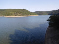
(7) Continue straight ahead along a track suitable for vehicles. Stop 200 m further on (elevation 928) for a superb view of a bend in the River Bès which encircles the hamlet of Laval on the opposite bank. Begin the descent with an S-bend, following the forest track which, 170 m further down, joins the remains of the Magnac cemetery by the river on the right at the Fork in the road.
(8) A small platform offers a chance to catch your breath before the climb back up, though without the comfort of the picnic table, which has ‘disappeared’. Climb back up to the Fork in the road and turn right. Cross the Ravin des Everses.
(On the left, the ascent to Fridefont via La Brugère can be reached by following faint yellow markings (in the opposite direction to the guidebook)). You’ll reach a notch where two other streams converge.
(9) Begin the steep climb up Les Charbonnières – which takes its name from a former mine (entry prohibited) – via the Mallet PR (a section shared with the Magnac route). Further up, join a track leading to a farm building. Reach Le Fau, on the Route de la Bessaire.
Back onto theGRP®
(10) Take the road on the left. At the next junction, continue left and pass through Le Puech. 500 m further on, you’ll come to a right-hand bend.
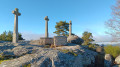
(11) Leave the tarmac and keep to the left on theGRP®. Return to the road at an imposing wayside shrine within an enclosure (a cross flanked by two statues). Carry on until you reach a road junction.
(12) Head straight ahead and, further on, cross the D13 to reach the cemetery, then continue to the Place de l’Église (S/E).

 Visorando Member

 AONB
 Easy