Las Combes

A short route to explore the Gorges du Bès

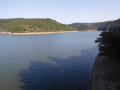
From Valiette, this route descends past the dam before entering the gorges, offering superb views of the valley.

Details

39273474
Creation:
Last update:
Last review:
  • Walking
    Activity: Walking
  • ↔
    Distance: 2.56 mi
  • ◔
    Average duration: 1h 35 
  • ▲
    Difficulty: Easy

  • ⚐
    Back to start: Yes
  • ↗
    Ascent: + 479 ft
  • ↘
    Descent: - 459 ft

  • ▲
    Highest point: 3,320 ft
  • ▼
    Lowest point: 2,867 ft

Photos

Description of the walk

(S/E) Valiette, Anterrieux

(1) From the village entrance, retrace your steps along the road and take the second path on the left. 

(2) At the road, turn left towards the dam, go round the back of the facilities and follow the path running parallel to the Bès for 1.5 kilometres.

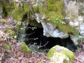
(3) After the old uranium mine entrances, take the path on the left, then turn left again onto a small track to rejoin the path leading back towards Valiette. (S/E)

Waypoints

  1. S/E : mi 0 - alt. 3,222 ft
  2. 1 : mi 0.01 - alt. 3,219 ft
  3. 2 : mi 0.56 - alt. 3,100 ft
  4. 3 : mi 2.08 - alt. 3,146 ft
  5. S/E : mi 2.56 - alt. 3,222 ft

Notes

Access:
Access to the start: to get to Valiette from ANTERRIEUX, take the RD 889 towards SAINT-CHELY, then turn left onto the small road towards the Gorges du Bès. Continue for 1 kilometre, then turn right towards Valiette. Park at the entrance to the village.

Reviews and comments

4 / 5
Based on 4 reviews

Reliability of the description
3.5 / 5
Ease of following the route
4.3 / 5
Route interest
4.3 / 5
User 18871878

Overall rating : 3.3 / 5

Date of your route : Mar 09, 2026
Reliability of the description : ★★★☆☆ Average
Ease of following the route : ★★★☆☆ Average
Route interest : ★★★★☆ Good
Very busy route : No

We couldn't find the path that goes up past the old uranium mines. So we continued on, which allowed us to reach a very beautiful viewpoint.

Machine-translated

User 23353071

Overall rating : 4 / 5

Date of your route : Aug 30, 2025
Reliability of the description : ★★★☆☆ Average
Ease of following the route : ★★★★★ Very good
Route interest : ★★★★☆ Good
Very busy route : No

You mention the RD 889 to reach the hike. In fact, it is the RD 989.

Machine-translated

User 13020636

Overall rating : 4.3 / 5

Date of your route : Aug 04, 2025
Reliability of the description : ★★★★☆ Good
Ease of following the route : ★★★★★ Very good
Route interest : ★★★★☆ Good
Very busy route : Yes

Be careful when walking along the river, as some sections are very narrow and rocky.
This route should be avoided with dogs and small children.
Otherwise, the route is very well marked.
The end of the trail has a steep climb back up to the starting point.
Enjoy your hike!

Machine-translated

User 26374244

Overall rating : 4.3 / 5

Date of your route : Jun 30, 2025
Reliability of the description : ★★★★☆ Good
Ease of following the route : ★★★★☆ Good
Route interest : ★★★★★ Very good
Very busy route : No

Access to the car park at the start of the route is clearly signposted.
You can even enjoy a meal before or after your hike at tables set up for this purpose.
Before reaching the dam, take the wooden steps that allow you to go around it at the top, as the access indicated on the app is blocked.
Pick up the trail a little further up.
A very beautiful hike.

Machine-translated

Other walks in the area

For more walks, use our search engine .

The GPS track and description are the property of this route's author. Please do not copy them without permission.