


 Country:

 City:
City:


Park at the Zimmermann Cross (472 m, Kaltenbach Club Vosgien Soultz rest area).
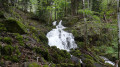
(S/E) Follow the road to the right for a few metres, then turn left onto the Red Triangle-marked path and walk over the waterfalls. Keep to the right when you reach the track, then turn left to emerge at the 602m mark onto the road leading to Col Amic.
(1) From this bend, head up to the left along the path marked with a Red Triangle. Ignore a path on the right and take the next path on the right.
(2) Continue straight on at the Fork in the road to reach a second fork at the Kohlschlag farmhouse inn (770 m).
(3) Turn left, then continue straight on to Col Amic (828 m), marked with a Red Triangle, to join theGR®®5Red Rectangle long-distance hiking trail.
(4) Turn left onto the path marked with a Yellow Ring to then reach the road. Follow it to the right onto the path marked with a Red Rectangle. Take the first path on the left to reach the Col du Freundstein (858 m). You can visit the ruins of Freundstein Castle or stop for a bite to eat at the farmhouse inn of the same name (follow the Red Rectangle with a white cross and retrace your steps). Continue to the next pass.
(5) Then head down to the left along the forest track marked with a Green Triangle. Immediately ignore a track on the left and two others on the right. Continue along the track to the next Fork in the road.
(6) Then head up to the left to the Sicurani Chapel (720 m, Club Vosgien Soultz shelter) via a path marked with a Yellow Disc, keeping to the right.
(7) From the chapel, continue along the path, then take a fairly steep path marked with a Yellow Disc on the right. Cross a track and continue past the Baratin shelter. Join a track.
(8) First turn right then left to come out onto a forest track marked with Yellow Discs, Green Triangles and Blue Triangles leading to the Zimmermann Cross (Kaltenbach rest area, Club Vosgien Soultz). Follow this track to the left as far as the cross (S/E).



 . The small access road to the Zimmermann Cross car park is closed to vehicles in winter... A bit of a problem; on foot, it adds 2.5 km to get to the car park.
 Visorando Member

 Tourism professional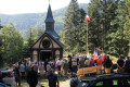
 Easy
Easy 
 Difficult
 Very difficult
