Country:
 City:


Access: from Saint-Louis, take the road leading to Les Makes, which passes the Antoine Roussin secondary school and the Parc du Gol. Drive past the park, then continue to the end of the road, taking the second exit at each roundabout. From there, turn right towards La Rivière (signposted). After the bridge over the Ravine Goyave, take the second road on the left (Rue Évariste de Parny). Carry on straight ahead until you reach the Alcide Barret school, situated at the end of the long straight stretch.
(S/E) Continue along Rue Évariste de Parny. The road climbs gently, winding its way through Ravine Casimir and Ravine Terres Rouges in turn. Occasional clearings offer views of the Gol-les-Hauts area.
(1) Stay on the same road until the second junction and take the second road on the left, Rue de la Commune de Paris. You’ll soon come to a small waterfall (which was dry that day). The path then passes by a few pitaya plants, which are in bloom at this time of year. After two bends, at the second one, ignore the path branching off to the left. Continue straight on until the next junction.
(2) At the end of the road, turn right onto Chemin Dejean. At the end of the road, turn left onto Chemin Neuf, then at the next bend, carry on straight ahead onto Chemin Ligne Charlette, which is a dirt track. Ignore the first three dirt tracks on the left (Caution: some are overgrown and difficult to see).
At the fourth junction, ignore the dirt track on the right and turn left. Then keep to the right until you reach the road.
(3) At the end of the dirt track, turn right onto Chemin Bois-Noir. This track winds twice before crossing through sugarcane fields and banana plantations, heading almost straight on.
(4) After a short series of bends, take the first dirt track on the right, which branches off at number 42 (on the left).
If the sugarcane has been cut, you may be able to see Piton la Mare and Piton de la Croix in the distance. At the second bend, ignore the overgrown dirt track branching off to the right and turn left instead.
(5) At the next junction, turn left towards the École Adrienne Lenormand. The path winds through fields of sugarcane before running alongside an orange grove. On reaching the sports hall, the track joins a tarmac road, which you should follow for a few metres until you reach the roundabout. Take the staircase starting to the right of the roundabout. At the top, turn right onto Chemin Fleury.
At the end of this path, turn left onto the famous and historic Route Hubert Delisle. Take two bends, then turn right onto Allée des Pensées (impossible to miss as a sign indicates the name of the lane). Follow this until it ends.
(6) Continue left onto Rue Pierre Payet. At the first junction, turn right onto Rue Julius Emma. The slope is steep for almost the entire length of the street! The first lychees of the route begin to appear. You may catch occasional glimpses of the ocean and the town of Saint-Louis. The final few metres of this street are very steep and can really put a strain on your calves.
At the end of Rue Julius Emma, turn left onto Rue du Père Laporte, which is a complete contrast to the previous street as it is almost completely flat! Stay on the same street until the second junction, then turn right onto Rue des Acalyphas. Take the small flight of steps which starts immediately on the left and leads to a narrow lane. At the end of this lane, turn left again onto Rue des Acalyphas. Stay on the same path until it ends.
(7) Turn right onto Route de Cilaos. This road is very busy whatever the day! You’ll pass a few lychee trees here too. Follow Route de Cilaos until you reach the next delicatessen on the left.
(8) Continue along the first path on the right, Chemin des Grenadiers. This runs alongside housing estates and climbs quite steeply. At the end, take the footpath which quickly leads to Rue Gonneau; follow this by turning right. From there, carry on straight ahead at every junction until you reach La Rivière church, situated on the right at the end of the street. Take a few minutes to visit it, then return to the previous junction (Rue Montseigneur de Beaumont), turn right onto this street and immediately carry on straight ahead along a small path that gradually turns into an alleyway.
(9) Take the first alleyway on the left, then take the first left again onto Rue Bellecombe. At the stop sign, carry on straight ahead. You’ll then cross a bridge.
(10) Then take the first dirt track on the right. You’ll pass very close to a fairly large reservoir where, if you’re lucky, you might spot some moorhens. You’ll then walk past a few houses before crossing some farmland. You’ll soon reach a meadow from where you can see the Chaîne du Bois de Nèfle! At the first junction, turn right onto another dirt track. This soon turns into a tarmac road. Then ignore the first two turnings on the right and keep to the left.
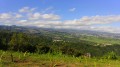
(11) At the end of the road, turn left onto Route Hubert Delisle. As you round the first bend, you’ll see Saint-Louis on the right (if the reeds have been cut back), the Tapage and the Chaîne du Bois de Nèfles on the left, and the Grand Serré, the Piton de la Croix and the Piton la Mare directly ahead (the latter is not marked on the IGN base map). Stay on the same road until the second junction.
(12) Turn right onto Chemin Benjoin. Continue to the Goyaves Marrons bus stop, then take the next lane on the left. At the end of this lane, join the track and follow it to Ravine Richard! I do not recommend taking children on this section. Do not cross or walk along Ravine Richard if the current is too strong.
Once you reach Ravine Richard, follow it to the right.
After the first few metres along Ravine Richard, you’ll come to an impressive waterfall! This is actually the spillway of the water reservoir that can be seen a little further up. Unfortunately, this impressive waterfall is only visible during heavy rain or when the reservoir is too full. After taking a few minutes to admire the waterfall, head back up Ravine Richard for a few hundred metres and turn right onto the first path leading to the picnic area, where there is a pond and a waterfall. Take one of the paths leading to the football pitch. Cross Chemin Benjoin and take one of the two paths that go round the water reservoir to the south and return to your car (S/E).

 Visorando Member
 Difficult

 Easy