The circular of the Canals

This is an original way to hike off the GR® trails. There are few trails winding through the Chaîne du Bois de Nèfle. This route takes you deep into the heart of this mountain range through a dense forest of colourful woods and offers some panoramic views of the south of the island and Les Makes. In addition, a picnic area has been set up at the end of the hike. Avoid this route in rainy weather!

Details

334995
Creation:
Last update:
Last review:
  • Walking
    Activity: Walking
  • ↔
    Distance: 7.34 km
  • ◔
    Average duration: 3h 40 
  • ▲
    Difficulty: Moderate

  • ⚐
    Back to start: Yes
  • ↗
    Ascent: + 536 m
  • ↘
    Descent: - 536 m

  • ▲
    Highest point: 1,027 m
  • ▼
    Lowest point: 491 m

Photos

Description of the walk

Access: From Saint-Louis, take the road that leads to Les Makes, passing in front of the Antoine Roussin secondary school and the Parc du Gol. Pass in front of the park and continue to the end of the road. From there, turn right towards La Rivière (signposted). Then take the second road on the left towards Les Canaux (signposted). Drive up to the village and park in front of the church. You can park higher up in a car park (see Practical Information section).

(S/E) Take a few minutes to see the Église des Canots, where there is a water source on the right-hand side, then continue up Chemin des Canots for a few metres.

(1) At the first crossroads, turn right onto Chemin de la Forêt. A damaged sign indicates the direction to follow to get to Le Trou, a place we will pass through in 3.5 km. The flat path offers beautiful views of the south! Enjoy them while you can, as they will be one of the few panoramic views on the climb! The end of the path marks the start of the trail! Set off along it. Don't hesitate to look back to enjoy the view of the eastern part of the village of Les Canots.

(2) The trail is wide and gently sloping until you reach an old picnic area. Once you pass this old picnic area, the going gets tough. Steps appear and the slope becomes steeper and steeper! The trail then plunges abruptly into a dense forest of colourful woods! Panoramic views will then become rare.

(3) About a hundred metres after the old picnic area, take the path on the left, but do not take the wide path that goes straight ahead! The path then runs along the left side of the Bras Chevrettes without ever crossing it. The path narrows at times. The steps become more and more numerous and higher and higher! There will be a few steep sections! Take advantage of the few false flats to rest, as they are immediately followed by a steep section! The path then crosses dry streams from time to time, which join the Bras Chevrettes further down.

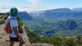
(4) The climb ends after an hour of sometimes steep walking and more than 500m of elevation gain. The trail then swings over to the other side of the Chaîne du Bois de Nèfle and offers a direct view of the Makes Biological Reserve! The trail then runs flat between tree ferns and chestnut vines.

(5) After 5 minutes of flat walking, the trail comes to an intersection. Turn left towards Le Trou (it is possible to go to La Fenêtre by turning right). Many roots slow down progress on this narrow trail.

(6) The trail widens at Le Trou. You will be treated to a few panoramic views of the Makes region as you cross the locality. Once you have passed the National Park boundary marker, the trail changes completely! It leaves the vineyard and plunges back into a forest of colourful trees! The slope also becomes steeper again and the trail winds its way downhill for about 150 metres. The end of the winding path is marked by a small forest of cryptomeria trees, a sign that we are approaching the picnic area. You will then come across three cryptomeria trees on your right, standing alone in the middle of a forest of colourful trees, which marks your imminent arrival at the picnic area.

(7) Ignore the paths leading to the tables and continue straight ahead at each junction. Before leaving the picnic area, look for the sign on the right for the association that maintains the picnic area, then turn left at the next junction. Leave the paths leading off to the left and right and stay on the main path. This path then becomes more slippery and stony.

(8) You will soon reach the Kiosque de la Pente Tunnel, where you can enjoy a beautiful view of Grand-Serré and the south of the island! After the kiosk, you can take the steep shortcut on the right (see practical information). Otherwise, continue straight ahead and turn left at the next junction. The wide, slippery path leads to a reservoir and a concrete road. Follow the concrete road and continue straight ahead at each junction. You will then come to a car park on your right and the start of a path.

(1) Go back to the junction you passed on the way there and continue straight ahead to reach the church (S/E).

Waypoints

  1. S/E : km 0 - alt. 491 m - Église des Canaux
  2. 1 : km 0.06 - alt. 498 m - Intersection, on the right
  3. 2 : km 0.95 - alt. 551 m - Former picnic area
  4. 3 : km 1.18 - alt. 573 m - Intersection, trail on the left
  5. 4 : km 2.78 - alt. 1,007 m - End of the climb
  6. 5 : km 3.18 - alt. 1,018 m - Intersection, on the left
  7. 6 : km 3.68 - alt. 975 m - Le Trou
  8. 7 : km 5.55 - alt. 682 m - Continue straight ahead.
  9. 8 : km 6.07 - alt. 640 m - Pente Tunnel kiosk
  10. S/E : km 7.34 - alt. 491 m - Église des Canaux

Notes

Avoid this route in rainy weather!
(7) Tables and shelter available.
(8) Kiosk available.
(S/E) Water point available on the right-hand side of the church.

After the Pente Tunnel kiosk, you can take a shortcut by turning right at the next intersection and then right again at the end.
Parking is available in a car park located slightly above the church. Stay on the same road until you reach the next car park on the left.

Worth a visit

See the Église des Canaux
See the viewpoint at the Pente Tunnel kiosk
You can continue to La Fenêtre by turning right at (5) (allow about 4 hours for the round trip).
You can make a detour via the Grand-Serré by taking the second path on the right when you reach the picnic area and return via the path that starts at the car park just before completing the circular (allow an extra 15 to 30 minutes).

Always be cautious and plan ahead when you're outdoors. Visorando and the author of this route cannot be held responsible for any accidents occurring on this route.

The GR® and PR® markings are the intellectual property of the Fédération Française de Randonnée Pédestre.

Reviews and comments

4.3 / 5
Based on 14 reviews

Reliability of the description
4.5 / 5
Ease of following the route
4.6 / 5
Route interest
3.7 / 5
chrisetchris
chrisetchris

Overall rating : 4 / 5

Date of your route : Mar 28, 2025
Reliability of the description : ★★★★☆ Good
Ease of following the route : ★★★★★ Very good
Route interest : ★★★☆☆ Average
Very busy route : No

Done in March 2025, after the cyclone passed. Above 800 m, there are many obstacles (branches, trees, bushes) across the path, as it has not yet been repaired, which is understandable. It must be a pleasant hike in the shade of the forest. The route and signposts are very helpful and accurate.

Machine-translated

Bernard63160
Bernard63160

Overall rating : 3.7 / 5

Date of your route : Dec 04, 2023
Reliability of the description : ★★★★☆ Good
Ease of following the route : ★★★★☆ Good
Route interest : ★★★☆☆ Average
Very busy route : No

At the start of the trail, the old wooden sign indicating the hole has disappeared, or at least we didn't notice it.
This hike, coming after two wet days, proved tricky in places (very slippery areas and small streams on the trails). This confirmed that it would be risky to venture out when it's raining.
Halfway along the trail, on the plateau, the path is very overgrown with lush, thorny vegetation. As pruning shears were not part of our small hikers' kit, our bare arms were left with nasty scratches despite our precautions. According to a local we met in the village, the route is not used and the problem of trail maintenance is real, partly due to the division of maintenance costs between the ONF and the municipality.
If you enjoy panoramic views, you will be disappointed. However, on a very hot day, this hike, which is mostly under dense cover, could be interesting.

Machine-translated

Fabrice79
Fabrice79

Overall rating : 3.7 / 5

Date of your route : Nov 22, 2023
Reliability of the description : ★★★☆☆ Average
Ease of following the route : ★★★★★ Very good
Route interest : ★★★☆☆ Average
Very busy route : No

Enter the name of the path: Canoes (Canals on maps)
Quite difficult in rainy weather, very slippery, very steep climb.
The descent is very slippery
towards point 4, the path becomes narrow and the vegetation is dense.
Moderate interest, no viewpoints.
Completed on 22 November 2023

Machine-translated

patvalence
patvalence

Overall rating : 4.3 / 5

Date of your route : Jan 10, 2022
Reliability of the description : ★★★★★ Very good
Ease of following the route : ★★★★★ Very good
Route interest : ★★★☆☆ Average
Very busy route : No

Hike as described, with an elevation gain of 600 m from the start.
There are no views of the landscape during the hike.
Not recommended for those who want to see the scenery!

Machine-translated

Patrick LEDOUX
Patrick LEDOUX

Overall rating : 3.7 / 5

Date of your route : Nov 01, 2021
Reliability of the description : ★★★★☆ Good
Ease of following the route : ★★★★☆ Good
Route interest : ★★★☆☆ Average
Very busy route : No

On the plus side: sporty, shaded
Negative points: no view, no clearing for picnics except at the end

Machine-translated

Jocelyn
Jocelyn

Overall rating : 4.3 / 5

Date of your route : Apr 10, 2021
Reliability of the description : ★★★★★ Very good
Ease of following the route : ★★★★☆ Good
Route interest : ★★★★☆ Good
Very busy route : Yes

Hike to do, trail in good condition, impossible to get lost. Some sections are quite physically demanding, though.

Machine-translated

sms20190
sms20190

Overall rating : 4.7 / 5

Date of your route : Sep 13, 2020
Reliability of the description : ★★★★★ Very good
Ease of following the route : ★★★★★ Very good
Route interest : ★★★★☆ Good
Very busy route : No

Circular completed today, perfect route (but rarely marked or signposted), impossible to get lost.
The trail is clean, with beautiful scenery all along the route. The undergrowth on the descent (or ascent, as indicated on Visorando) is of little interest.
We met about 12 people (3 small groups) in 3.5 hours.

Without a doubt, my Suunto watch recorded the route as 9.3 km with 660 m of elevation gain.

We did the route in the opposite direction to the description, with a picnic area at the start and another at the end.

In both cases, it was a circular that we recommend.

Machine-translated

Marco1383
Marco1383

Overall rating : 4.3 / 5

Date of your route : Sep 30, 2019
Reliability of the description : ★★★★☆ Good
Ease of following the route : ★★★★★ Very good
Route interest : ★★★★☆ Good

The route starts off gently in a bucolic setting, then comes the first seemingly endless staircase.
There is a 500-metre climb over a distance of just 3 km.
If you want to make good progress, this route is only suitable for trained walkers, unless you are prepared to take a break every 15 metres.
On the return leg of this circular, be careful as the sun does not penetrate the trees, resulting in very wet and slippery ground.
Otherwise, it's nice to walk in this very exotic forest. Hike completed at the end of September 2019.

Machine-translated

hoareaujeremy1983
hoareaujeremy1983

Overall rating : 4.3 / 5

Date of your route : Oct 21, 2018
Reliability of the description : ★★★★★ Very good
Ease of following the route : ★★★★☆ Good
Route interest : ★★★★☆ Good

Very good hike, it all depends on which direction you want to go, especially with children.

Machine-translated

florine974
florine974

Overall rating : 4.7 / 5

Date of your route : Aug 07, 2018
Reliability of the description : ★★★★★ Very good
Ease of following the route : ★★★★★ Very good
Route interest : ★★★★☆ Good

I had already done this hike several times before, and this time I was very pleasantly surprised by how well it had been maintained. Great. And the picnic area at the end of the hike has regained all the charm it had when it was first created. A very nice getaway.

Machine-translated

komanile974
komanile974

Overall rating : 4.3 / 5

Date of your route : May 26, 2018
Reliability of the description : ★★★★★ Very good
Ease of following the route : ★★★★☆ Good
Route interest : ★★★★☆ Good

Circular hike. Depending on which direction you start, it's steep from the beginning or at the end. We started by climbing. It's steep! And finished at the kiosk. I prefer this direction because the hike ends gently.

Be careful, it can be slippery, very slippery, especially if it has rained beforehand!!!

Machine-translated

Orando974
Orando974 ★
• Edited:

Thank you for your feedback, I'm delighted that you found my information useful!

I can confirm that this trail can become a real ice rink at the slightest drop of rain (I live nearby and have done it several times after rainy spells), regardless of which direction you choose! As mentioned, this hike should be avoided in rainy weather.

A small correction: on the contrary, the dry season only begins around April-May and the rainy season arrives around December-January. During this period, the trails are muddier/slippery, especially if you go east. They are drier around July-August.

Machine-translated

saker777
saker777
• Edited:

Overall rating : 5 / 5

Date of your route : Oct 29, 2017
Reliability of the description : ★★★★★ Very good
Ease of following the route : ★★★★★ Very good
Route interest : ★★★★★ Very good

I chose this hike because it wasn't too long, it was close to my lodge (Etang Salé) and it went through quite a bit of forest.

I wasn't disappointed because we were almost always in the forest, and I came across a golden orb-weaver spider and several endemic birds.
As a photographer, I was delighted!

Thanks to orando974 for the accuracy of his route and information on the various waypoints. Everything was spot on.

I would add that the paths were very wet and slippery, as Otando974 rightly said.

There were several dry stream crossings for me, but I think that in the middle of the wet season, this hike must become much more challenging and could probably be reclassified as difficult despite its short duration.

Machine-translated

Wasey
Wasey

Overall rating : 4 / 5

Date of your route : Aug 18, 2017
Reliability of the description : ★★★★☆ Good
Ease of following the route : Not used / Not applicable
Route interest : ★★★★☆ Good

Lovely forest trail with beautiful picnic areas.

Machine-translated

Orando974
Orando974 ★
• Edited:

For randooccas: Unlike the Dimitile Massif, there are few trails and tracks criss-crossing this massif. However, if you're interested, I know of two other routes that criss-cross the Chaîne du Bois de Nèfles. The first is the trail that connects Tapage to Les Makes: https://www.visorando.com/randonnee-du-ta... A little better known than the Canots circular, the start of the trail on the Tapage side is, however, very poorly marked. But the hike is well worth the detour, with beautiful views of the south and the Cirque de Cilaos.
I highly recommend a machete and GPS for those doing it for the first time! But as is the case with this trail, it's difficult to go as deep into the Chaîne du Bois de Nèfles.

As you also mentioned, after the picnic area you mentioned, the slope only gets steeper until you reach the other side of the Chaîne du Bois de Nèfles, where the trail is also less well maintained (I went back several months ago for another hike).

I hope this has been helpful in your search for trails in this area.

Orando974

Machine-translated

Other walks in the area

For more walks, use our search engine .

The GPS track and description are the property of this route's author. Please do not copy them without permission.