Elevation gain of only 80 metres.
Access: On the N3, between Chemin Ceinture and Pont Payet, head towards Grand Étang until you reach the picnic area (3km).
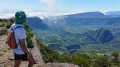
(S/E) The hike begins on a stony track sometimes used by horse riders, heading west. Further on, it climbs steeply at times through the woods.
(1) When you reach the pond, enjoy the view and take a look at the information board. Follow the Tour de Grand Étang trail, turning left. It is a pleasant walk through tall vegetation.
(2) The path runs along a rocky ridge with a handrail. If you do not want to walk along the rock or if the path is submerged, take the path on the left and the ladders that allow you to cross the ridge.
(3) The path forks to cross the end of the lake and passes through tall vegetation. The path may be muddy.
(4) At the crossroads, follow the path to the left towards the Bras d'Annette waterfalls. The climb to the waterfalls is short but quite steep, and the path quickly runs alongside the Bras d'Annette. When the path narrows, the steps become higher and there are more rocks, you are approaching the waterfall.
(5) Once you reach the foot of the waterfalls, take a moment to enjoy the view. Return via the same path to the previous junction.
(4) Continue straight ahead to continue around the lake. The path is damp in the undergrowth and, depending on the season, frogs may jump out of your way as you pass. Pass under the power lines and turn left at the crossroads at the edge of the lake.
(1) Take one last look at the Grand Étang and return to the car park via the same route you took on the way there (S/E).