


Access from Saint-Benoit
Head towards Plaine-des-Palmistes and then Petite-Plaine. On leaving the village of Petite-Plaine, turn right onto Route Forestière 2 de Bébour-Bélouve towards the Bébour forest. Pass the Col de Bélouve (7 kilometres after the Bébour forest). Continue on the same road until you see the sign for the École Normale trail on the right-hand side of the road.
Access from Bourg-Murat
Continue towards Plaine des Palmistes. Pass Col de Bellevue. 5 kilometres after the pass, at the first crossroads, turn left onto the D55 towards Petite-Plaine. Take the first road on the left (Route Forestière 2 de Bébour-Bélouve) towards the Bébour Forest. Pass the Col de Bélouve (7 kilometres after the Bébour Forest). Continue on the same road until you see the sign for the start of the École Normale trail on the right-hand side of the road.
(S/E) Pass the sign and the barrier, then continue on the concrete road for 200 metres.
(1) Turn right onto the École Normale trail. A hundred metres further on, the trail crosses the Ravine Mazerin and heads towards the Plateau Citrons. Most of the time, the trail runs along a wooden walkway. When the trail runs along the ground, it is extremely muddy and slippery! Forty minutes after the start, the trail leads to a forest track, which you will need to follow for about a hundred metres.
(2) At the first intersection, turn right onto Forest Track 27 des Mares.
(3) Turn right again a few metres further on, towards the Grande Mare.
The most difficult part begins here and continues to the Grande Mare.
(4) At the next intersection, leave the path that goes around the pond on your right and continue straight ahead.
(5) A few metres further on, leave the path on the right and take the one on the left.
From this point, the path is paved and crosses the Plateau Cochons.
(6) Leave the path leading to Bras-Panon (difficult path) on your right and continue straight ahead.
(7) A few metres further on, leave the path leading to Allée Cavalière on your left and turn right.
(8) At this intersection, turn right towards the viewpoint.
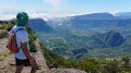
(9) Go to the viewpoint, where you can enjoy a magnificent panorama of the Trou de Fer, provided you arrive early in the morning! Return to the crossroads by the same route.
(8) Turn left and continue to another junction.
(7) Turn right towards Allée Cavalière. Walk along this pleasant track for 1 hour. Leave the Trou de Fer trail on your right and continue straight ahead on the track.
(10) Visit the Queen of Tamarins. To do so, take the next path on the left of the track. This is a 300-year-old tamarind tree with an enormous trunk! Then return to the crossroads.
(10) Turn left onto Allée Cavalière. At the next intersection, leave the path leading to Lodge de Bélouve on your right and continue straight ahead.
(11) About 100 metres further on, leave the Piste Forestière 27 des Mares on your left and turn right onto Allée Cavalière. Continue to the end of the track, which leads to Route Forestière 2 de Bébour-Bélouve.
(12) Then turn left towards the starting point. Follow the forest road for 1.5 kilometres. Then leave the Piste Forestière de la Vierge on your right and turn left.
Cross Ravine Mazerin again and continue along the same road for 200 metres to the car park (S/E).

 I wish you a wonderful hike at Trou de Fer!


