Cascade-Blanche

From the Pont-de-L'Escalier car park, take a path of about three and a half kilometres that will take you to Cascade-Blanche, the third highest waterfall in France.

Details

2249131
Creation:
Last update:
Last review:
  • Walking
    Activity: Walking
  • ↔
    Distance: 3.25 km
  • ◔
    Average duration: 1h 50 
  • ▲
    Difficulty: Moderate

  • ⚐
    Back to start: Yes
  • ↗
    Ascent: + 306 m
  • ↘
    Descent: - 299 m

  • ▲
    Highest point: 366 m
  • ▼
    Lowest point: 230 m

Description of the walk

(S/E) From the Pont-de-L'Escalier car park, located on the left just after the bridge when coming from Saint-André, take the stairs and follow the path, which is about the width of a car, to the entrance of a property.

(1) Turn right and watch out for dogs, as they can be aggressive and throw themselves against the fence. Follow the path to the viewpoint.

(2) Continue past this beautiful viewpoint of the waterfall to the end of the path just after the river crossing.

(3) Turn around to return to the Pont-de-l'Escalier car park (S/E).

Waypoints

  1. S/E : km 0 - alt. 265 m - Pont-de-l'Escalier car park
  2. 1 : km 0.56 - alt. 254 m - Property entrance
  3. 2 : km 1.44 - alt. 283 m - Viewpoint
  4. 3 : km 1.62 - alt. 276 m - End of the trail
  5. S/E : km 3.25 - alt. 265 m - Pont-de-l'Escalier car park

Notes

  • Walking boots.
  • Walking sticks for those who use them.
  • Mosquito repellent.

Worth a visit

View of the Rivière-du-Mât from the car park.
Restaurant before or after the hike, right at the starting point.

Reviews and comments

4.6 / 5
Based on 7 reviews

Reliability of the description
4.7 / 5
Ease of following the route
4.7 / 5
Route interest
4.4 / 5
ombrageux
ombrageux

Thank you for your feedback.

Machine-translated

Denyss
Denyss
• Edited:

Overall rating : 5 / 5

Date of your route : Mar 17, 2026
Reliability of the description : ★★★★★ Very good
Ease of following the route : ★★★★★ Very good
Route interest : ★★★★★ Very good
Very busy route : No

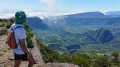
After an initial, relatively flat section—nicely paved and well-maintained—which leads to the cave’s side passage and follows it, there is a succession of six rollercoaster-like sections that take you slightly away from the ravine, overlooking it. Only the first one has a noticeable incline, which is quickly overcome. You then descend back towards the ravine to point 2, which is completely unobstructed and offers a superb view of one of the world’s highest waterfalls: a 640-metre drop.
Continuing along the ravine, you can descend into the stream to reach the swimming pools (caution: very slippery rocks), just before a sign warning of unstable ground.
Continue to point 3 before turning back.
Finally, contrary to the review dated 23/12/2025, access to the ravine is possible, and there is a superb view of the waterfall, thanks to the ongoing ‘green spaces’ works. A lovely, quick walk where you can swim or even have a picnic along the way; I recommend it.

Machine-translated

HélèneGr
HélèneGr
• Edited:

Overall rating : 3.7 / 5

Date of your route : Dec 23, 2025
Reliability of the description : ★★★★☆ Good
Ease of following the route : ★★★★☆ Good
Route interest : ★★★☆☆ Average
Very busy route : No

Completed on 23/12/2025 in pouring rain. Be careful not to slip on the way down.
Be careful, there is a place where the mountain is crumbling and the passage is only about 30 centimetres wide and a good metre long. You can hold on to the cable, but be careful of the fixings as well. In my opinion, this passage is very dangerous.
Ultimately, this is a very short hike with little to offer, as it is not possible to reach the foot of the waterfall and the view is limited by the trees.

Machine-translated

Lastouf
Lastouf

Overall rating : 5 / 5

Date of your route : Oct 27, 2025
Reliability of the description : ★★★★★ Very good
Ease of following the route : ★★★★★ Very good
Route interest : ★★★★★ Very good
Very busy route : No

A walk with a few slightly technical sections, but nothing extraordinary. Done with my wife and my 16- and 18-year-old children. The walk is quite short, taking us about an hour and a half there and back at a leisurely pace, through the forest the whole way, so sheltered from the sun. The waterfall is magnificent. The end of the route leads to the river, a pleasant spot where you can sit for a while and have a bite to eat if you've brought a picnic.

Machine-translated

Orando974
Orando974 ★

Overall rating : 5 / 5

Date of your route : Dec 27, 2024
Reliability of the description : Not used / Not applicable
Ease of following the route : Not used / Not applicable
Route interest : ★★★★★ Very good
Very busy route : Yes

A pleasant little hike that can be done before or after a more in-depth visit to the cirque. The walk is neither too difficult nor too easy, but it is very short. The waterfall is majestic when it is full of water. Including Réunion, it is the third highest waterfall in mainland France (the other two are also in Réunion).

Machine-translated

Kenimo
Kenimo

Overall rating : 5 / 5

Date of your route : Oct 22, 2024
Reliability of the description : ★★★★★ Very good
Ease of following the route : ★★★★★ Very good
Route interest : ★★★★★ Very good
Very busy route : No

Short, easy hike, completed in 1.5 hours. A bit muddy towards the end. Beautiful waterfall.

Machine-translated

mamanconfiture67
mamanconfiture67

Overall rating : 4 / 5

Date of your route : Oct 05, 2024
Reliability of the description : ★★★★☆ Good
Ease of following the route : ★★★★☆ Good
Route interest : ★★★★☆ Good
Very busy route : Yes

We went on the hike, there are a few difficulties in some places.

Machine-translated

danielfr40
danielfr40

Overall rating : 4.7 / 5

Date of your route : Mar 21, 2023
Reliability of the description : ★★★★★ Very good
Ease of following the route : ★★★★★ Very good
Route interest : ★★★★☆ Good
Very busy route : Yes

A short, easy, well-maintained hike leading to this huge waterfall
Thank you for this route

Machine-translated

Other walks in the area

For more walks, use our search engine .

The GPS track and description are the property of this route's author. Please do not copy them without permission.