Country:

 City:
City:


Car park at Place de la République, between the fire station and the post office.
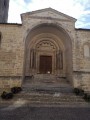
(S/E) Make your way to the bottom of the car park (village map by the roadside). Cross at the pedestrian crossing, very close to No. 29, to find the Chapelle des Pénitents opposite. If you head to the right, you can see the entrance to the chapel.
Return to the car park and head right towards the Post Office, at the top left of the car park. Climb the steps to the right of the Post Office and turn left to go round the front of the Temple.
Turn round and head back down to the Grande Rue (with a florist on the corner). Cross the street to find the remains of the Porte Aiguière opposite.
Turn left and walk up the Grande Rue on the right-hand pavement; 10 metres further on, on the right, you’ll find the Pilori.
Carry on straight ahead (ignore the road on your right despite a ‘Sentier du Patrimoine’ sign instructing you to follow it) and walk a few steps until you reach the steps leading up to Notre-Dame Church. Look above the door to see the Charter of the Franchisés.
Walk a few more metres, pass the war memorial pressed up against the church wall, and look at the corner of the building to see the grain measure leaning against the wall.
Turn right behind the church, climb a few steps and follow the narrow lane to the right which winds round the building. At the very end, look to the right to see the entrance to Notre-Dame Church.
(1) Turn left, go under the porch and walk up Rue Vente-Cul. It curves to the left and leads to a small square. On the left is the former vicarage.
Walk a few steps further to see the Chapelle des Pénitents slightly to the right opposite.
Carry on straight ahead along Rue de la Roche and, at the end, turn left down Rue Monestier. After No. 8, you’ll find some steps on the right leading up to Château Saint-Ange.
Return to the street and follow it to the right. After No. 6, turn right again into the narrow staircase-lined alley. Turn left at the corner of the house to go down to Rue Barelière. Cross the street and head straight ahead on the left into Rue de la Peyrouse, which leads uphill. Pass two flights of steps and you’ll reach the top of the street. Turn left in front of No. 1 (there’s a view if you turn round), cross a small square and continue straight on to reach Place de la Peyrouse.
Head down a narrow lane on the left and carry on to No. 9. Just after this, turn left and go down another paved slanting street (Rue de la Fontaine Couverte) which joins the main street. On the left-hand corner, beneath the house, is the Fontaine Couverte.
Turn right and walk up the Grande Rue to Place de la Fédération. On the right is the Monument de la Fédération.
Cross the square to the left to reach the Lavoir.
(2) Facing the information board, turn left, go up the wide steps and cross the car park at Place d’Armes. At the very end, cross at the pedestrian crossing and continue straight ahead along the paved path. 50 metres further on, turn left and enter the Parc du Château.
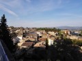
(3) Follow the path on the right to the viewpoint overlooking the village. Return via the other path (there are only two!) to the entrance gate. Turn left towards the water tower. Turn left into Rue de Laye, which winds its way down, skirting the park’s retaining wall.
Let the road take you down two streets to the right and continue along Rue des Fontaines, which leads to the entrance to the Château de Diane de Poitiers.
Turn right onto Place Léon Terisse and, at the end, on the right, you’ll find the Renaissance Tower.
Turn right and walk down the main street to No. 45, where the Town Hall is located (during opening hours, you can go inside and visit the courtyard).
Continue down the Grande Rue and head towards Place de la République (S/E).
 Visorando Member




 Moderate