Mont de Clais

A route around Mont de Clais, which overlooks the small Bray village of the same name, nestled in the Eaulne valley. During the route, you’ll pass through fields and hamlets.

Details

348074
Creation:
Last update:
Last review:
  • Walking
    Activity: Walking
  • ↔
    Distance: 7.19 mi
  • ◔
    Average duration: 3h 50 
  • ▲
    Difficulty: Moderate

  • ⚐
    Back to start: Yes
  • ↗
    Ascent: + 646 ft
  • ↘
    Descent: - 646 ft

  • ▲
    Highest point: 722 ft
  • ▼
    Lowest point: 315 ft

Photos

Description of the walk

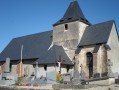
Start from the car park opposite Clais Church.

(S/E) Cross Rue de l’Église at the pedestrian crossing. On your right, walk alongside the cemetery wall. Take the first street on your left, Rue du Presbytère. Continue to the junction with Rue du Val Ricard.

(1) Take Rue du Val Ricard on your left. At the top of the street, turn right at the hiking trail sign.

(2) Take this tarmac track leading to the Ferme du Val Ricard and carry on until you reach a Fork in the road.

(3) Take the dirt track on your left, which climbs for approximately 1.9 km. At the top of the track, continue to your left until you reach the tarmac road, the Route de Neuville.

(4) Turn right and carry on along this road until you reach the first track on your right. Follow the grassy track which leads to the edge of the hamlet of Crimont.

(5) You’ll come to the D14: turn right towards the hamlet of Hambures. Drive through the hamlet, staying on the D14, until you reach the junction with the D214 and the D59.

(6) Cross the junction and, after the wayside cross, turn right onto Rue des Longchamps, which ends in a grassy, stony track. Continue along this track, which descends towards the hamlet of Fresnoy en Val, some 1.7 km away, ignoring the track on your right.

(7) Walk through the hamlet and, at the Fork in the road, continue to the right along the road until you reach the junction with the D14.

(8) Take the D14 on your left, which descends towards Clais, until you reach the junction with the D36.

(9) Turn right, pass the village hall and school on your right, and continue straight on along Rue de l’Église to reach the car park opposite the church (S/E).

Waypoints

  1. S/E : mi 0 - alt. 315 ft - Car park opposite the church. Near the - Eaulne (rivière) - Affluent de l'Arques
  2. 1 : mi 0.1 - alt. 344 ft - Rue du Val Ricard
  3. 2 : mi 0.27 - alt. 367 ft - Road leading to La Ferme du Val Ricard
  4. 3 : mi 0.6 - alt. 489 ft - Turn left at the fork in the road
  5. 4 : mi 2.23 - alt. 463 ft - Route de Neuville
  6. 5 : mi 3.32 - alt. 709 ft - D14, exit at the hamlet of Crimont
  7. 6 : mi 3.83 - alt. 722 ft - Calvary
  8. 7 : mi 5.04 - alt. 499 ft - Fresnoy-en-Val hamlet
  9. 8 : mi 6.39 - alt. 459 ft - D14
  10. 9 : mi 6.87 - alt. 367 ft - Junction of the D14 and D36
  11. S/E : mi 7.19 - alt. 315 ft - Car park opposite the church

Worth a visit

Reviews and comments

4.4 / 5
Based on 3 reviews

Reliability of the description
4.7 / 5
Ease of following the route
4.7 / 5
Route interest
4 / 5
BaladeRando
BaladeRando

Overall rating : 5 / 5

Date of your route : Aug 21, 2023
Reliability of the description : ★★★★★ Very good
Ease of following the route : ★★★★★ Very good
Route interest : ★★★★★ Very good
Very busy route : No

It’s a really good route in the Pays de Bray, offering a good mix of tarmac and tracks, despite the overcast, misty weather and a heavy downpour towards the end of the ride.

Machine-translated

lannel
lannel

Hello,

Thank you for your very kind comment. That’s very nice of you.
I’d like to invite you to take a look at the two new walks that have been approved:
The ponds and forest of Saint Hellier
Touffreville-sur-Eu, seen from above and below.

Enjoy your walks

Kind regards.

Nadège Lannel

Machine-translated

lannel
lannel

Hello,

Thank you for your very kind comment. That’s very nice of you.
I’d like to invite you to take a look at the two new walks that have been approved:
The ponds and forest of Saint Hellier
Touffreville-sur-Eu, seen from above and below.

Enjoy your walks.

Kind regards

Nadège Lannel

Machine-translated

Claire61
Claire61

Overall rating : 4.3 / 5

Date of your route : Mar 27, 2017
Reliability of the description : ★★★★★ Very good
Ease of following the route : ★★★★★ Very good
Route interest : ★★★☆☆ Average

A route you can follow with your eyes closed – very well explained; you hardly need to look at the map. A rolling landscape that’s worth exploring time and time again.

Machine-translated

LAMICHEDEVO
LAMICHEDEVO

Overall rating : 4 / 5

Date of your route : Mar 27, 2017
Reliability of the description : ★★★★☆ Good
Ease of following the route : ★★★★☆ Good
Route interest : ★★★★☆ Good

C Good! Carry on!

Machine-translated

Other walks in the area

For more walks, use our search engine .

The GPS track and description are the property of this route's author. Please do not copy them without permission.