The Wismes Loop

Nothing spectacular, but a good day out in the fresh air. It’s best to go during dry spells, as some paths can become quite (or even very) difficult.
You could also consider starting from Wismes (car park by the church), which allows you to leave your picnic in the car and thus take some of the strain off your back.

Details

1393418
Creation:
Last update:
Last review:
  • Walking
    Activity: Walking
  • ↔
    Distance: 13.08 mi
  • ◔
    Average duration: 6h 50 
  • ▲
    Difficulty: Difficult

  • ⚐
    Back to start: Yes
  • ↗
    Ascent: + 909 ft
  • ↘
    Descent: - 902 ft

  • ▲
    Highest point: 620 ft
  • ▼
    Lowest point: 259 ft

Description of the walk

Start from Nielles-les-Bléquin, a small square near the town hall (la Place).

(S/E) Walk to the right of the town hall and continue to the T-junction. Turn right and head towards the D202. Follow it to the left for about a hundred metres.

(1) Take the path on the right. It turns right and joins the D191. Follow it for about fifty metres on the left.

(2) At the three-way junction, take the wide path on the left and follow it to the D131.

(3) Cross the road and continue straight ahead on the wide path. Ignore a path on the left and continue to a three-way junction.

(4) Turn right and join a small road. Follow it to the left until you reach a T-junction. Turn right into Rue du Calvaire.

(5) At the end of the street (with the calvary on the left), turn right onto the D205. Just before the left-hand bend, turn right onto a grassy path. This leads up the Grande Vallée and reaches a T-junction.

(6) Then turn left to head down towards Wismes. After a large farmhouse, ignore the path on the right and walk past the school to reach a T-junction.

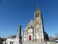
(7) Turn right and, as you round the bend, leave the tarmac to take a lovely path opposite which leads down to the church.

(8) Turn left onto Rue Principale. 100 metres further on, turn right and walk past the inn. Ignore a street on the right and a path on the left. The street bends to the left. Ignore the road that veers sharply to the right and turn right onto the main road to reach the stadium.

(9) Stay on the tarmac to pass to the right of the stadium. At the junction, carry on straight ahead along a wide path. Pass under the power line and, at the junction (elevation 143), carry on straight ahead. Shortly afterwards, the path narrows and becomes more overgrown for a few hundred metres (likely very damp in places). It widens again shortly afterwards and, after a left-hand bend, joins a small road.

(10) Follow it to the right and head uphill to the D341. Cross it (take care!) and head straight on. Turn right immediately (there used to be picnic tables here, but I didn’t see them yesterday). Turn left and follow the correct path. At the junction, carry on straight ahead to reach a second junction where you’ll find theGR®127B(signposted), which you’ll follow all the way to Vaudringhem.

(11) Turn right onto the tarmac road. At the first bend, leave the tarmac and take a path straight ahead (we’ve found it very wet in the past and it’s sometimes better to go round it: easy to do with the map). You’ll come to a house.

(12) Turn right onto the footpath. You may come across a metal gate, which opens easily. Next, you’ll need to pass through a double barbed-wire fence (make sure to close it properly behind you!). This path is a ‘cattle track’, so it can sometimes be quite difficult. Turn right, then left, to reach a small road (with a grass verge).

(13) Turn left until you reach the junction.

(14) Turn immediately right (not onto the D191). Pass the Fosse au Lait Battu (!!!) and head uphill to reach the D341. Cross it and continue straight ahead for a few metres.

(15) At the three-way junction, take the grassy path on the left (arrows). It descends and leads to Wismes. Cross the D132 and take the path opposite, which first turns right then left to reach a T-junction.

(16) Turn left and stay on the right-hand path until you reach the D191. Cross it and follow the path opposite for a few tens of metres.

(17) Turn right onto the path, cross the D131 and head downhill (quite difficult) until you reach a small road.

(18) Follow it for a few dozen metres to the right. At the three-way junction, turn right onto the wide path. Cross the D203 and arrive at a metal wayside cross, where you leave theGR® (it heads off to the left).

(19) Continue straight ahead to the D203. Cross it and take the path opposite leading to Le Bléquin. Follow the stream, keeping to the right bank, and head for the square (S/E).

Waypoints

  1. S/E : mi 0 - alt. 262 ft - Nielles-lès-Bléquin, the Square
  2. 1 : mi 0.28 - alt. 279 ft - Path on the right
  3. 2 : mi 0.63 - alt. 305 ft - Three-way junction on the D191
  4. 3 : mi 1.63 - alt. 518 ft - D131
  5. 4 : mi 2.27 - alt. 436 ft - Three-way junction to the right
  6. 5 : mi 2.71 - alt. 420 ft - Calvaire
  7. 6 : mi 3.25 - alt. 472 ft - Turn left towards Wismes
  8. 7 : mi 3.71 - alt. 492 ft - T-junction after the school
  9. 8 : mi 3.84 - alt. 420 ft - Wismes Church
  10. 9 : mi 4.17 - alt. 492 ft - Stadium
  11. 10 : mi 5.72 - alt. 410 ft - A small road near Forestel
  12. 11 : mi 7.43 - alt. 551 ft - Crossroads near Cloquant. GR to the right
  13. 12 : mi 7.62 - alt. 522 ft - End of the trail, opposite the house.
  14. 13 : mi 8.06 - alt. 486 ft - Rempaillage
  15. 14 : mi 8.73 - alt. 597 ft - Junction with the D191
  16. 15 : mi 9.28 - alt. 607 ft - A three-way junction after crossing the D341
  17. 16 : mi 9.99 - alt. 515 ft - T-junction
  18. 17 : mi 10.98 - alt. 607 ft - Path on the right after crossing the D191
  19. 18 : mi 11.61 - alt. 486 ft - Small road on the right
  20. 19 : mi 12.06 - alt. 387 ft - Metal wayside cross
  21. S/E : mi 13.08 - alt. 262 ft - Nielles-lès-Bléquin, the Square

Notes

As always, the same advice applies: wear good walking shoes and take a walking stick or two.

In Vaudringhem (5 minutes from the metal wayside cross: point (19)) there’s a café where we received a warm welcome (03 21 39 82 83). Ideal for a picnic if setting off from Wismes.

Looking at the map, you’ll realise that there are plenty of shortcuts available, but I preferred to stick to the paths.

It’s also easy to split this into two routes of around ten kilometres each.

Finally, one regret: the few animals we came across.

And for keen walkers, at point (19) you can add on the “Balade sur les Hauts d’Artois” (from point (2) to point (1)) to create a route of around 35 km.

Always be cautious and plan ahead when you're outdoors. Visorando and the author of this route cannot be held responsible for any accidents occurring on this route.

The GR® and PR® markings are the intellectual property of the Fédération Française de Randonnée Pédestre.

Reviews and comments

4.3 / 5
Based on 3 reviews

Reliability of the description
4.3 / 5
Ease of following the route
4.7 / 5
Route interest
4 / 5
debrie
debrie

Overall rating : 3.3 / 5

Date of your route : Jul 20, 2024
Reliability of the description : ★★★★☆ Good
Ease of following the route : ★★★★☆ Good
Route interest : ★★☆☆☆ Disappointing
Very busy route : No

A rather uninteresting circular route. Lots of tarmac paths. A few rare picturesque stretches, but some are unfortunately being used as rubble dumps… We didn’t actually see any animals. On the other hand, there was an almost constant smell of manure.

Machine-translated

Rando59223
Rando59223

Overall rating : 4.7 / 5

Date of your route : Sep 14, 2019
Reliability of the description : ★★★★☆ Good
Ease of following the route : ★★★★★ Very good
Route interest : ★★★★★ Very good

A magnificent walk, which I extended by a further 11 km by following, for the most part, the PR trail that heads north through the woods.
This extra section is very steep but very pleasant (I spotted three birds of prey there) and contrasts with the flatter southern part of the walk.
32 km in 5 hours.
It’s true that this route follows roads, but there were few cars out on this Saturday. No cars on the tracks, but occasionally some fast quad bikes (thanks for the dust). Danger is everywhere.

Machine-translated

Stef3291
Stef3291

Overall rating : 5 / 5

Date of your route : Sep 10, 2018
Reliability of the description : ★★★★★ Very good
Ease of following the route : ★★★★★ Very good
Route interest : ★★★★★ Very good

Hello,
A lovely walk, though it does involve a bit too much walking along narrow roads – but nothing too troublesome.
That said, we didn’t see many animals, apart from a roe deer towards the end of the route
My heartfelt congratulations to the person who created this walk

Machine-translated

Other walks in the area

For more walks, use our search engine .

The GPS track and description are the property of this route's author. Please do not copy them without permission.