Le Fond de Juis in Savigneux

A relaxing route in natural surroundings. Highlights include a14th-century brick fortified castle and a pond.

Details

6474562
Creation:
Last update:
Last review:
  • Walking
    Activity: Walking
  • ↔
    Distance: 7.74 mi
  • ◔
    Average duration: 3h 40 
  • ▲
    Difficulty: Moderate

  • ⚐
    Back to start: Yes
  • ↗
    Ascent: + 144 ft
  • ↘
    Descent: - 144 ft

  • ▲
    Highest point: 928 ft
  • ▼
    Lowest point: 817 ft
  • ⚐ Country: France
  • ⚐ City: Savigneux (01480)
  • ⚑
    Start/End: N 46.001477° / E 4.848745°
  • ❏
    IGN map(s): Ref. 3030SB
  • Hour-by-hour weather

Photos

Description of the walk

Park in the church car park. This route is signposted with hiking posts; yellow paint markings will be introduced shortly.

(S/E) From the car park, turn left onto Rue de l’Église towards Ars-sur-Formans and the Route des Dombes, which you will follow to the right for about a hundred metres.

At the first junction, turn left onto the Route de Rancé, heading due south. Pass the ruins of the Priory of Montberthoud, founded around the year 1000, of which only part of the façade remains today, incorporated into another building. Continue to the Champ Marguerite junction.

(1) Turn right and follow the route alongside the Domaine de Fontanelle as far as La Rose.

(2) At a place called La Rose, follow the road as it bends to the left and continue due south to Champ Perret.
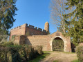
On your right, the Monts du Beaujolais come into view, and a distinctive red-brick building appears on your left: the Donjon de Juis.

(3) At the multi-way junction in Champ Perret, turn left towards Rancé, cross the D88 – from where you’ll have a view of the Château de Juis – and carry on straight ahead.

(4) Cross the bridge over the TGV line after the hamlet of Les Grandes Terres, then head slightly to the right towards the hamlet of Fond de Juis and Rancé, on the edge of the woods. Turn left to follow the banks of the Étang de la Dombes.

(5) At Fond de Juis, stop by the sluice gate of the pond and admire the unique spectacle of ducks and other birds performing graceful dances on the water. Then follow the path towards Rancé along the edge of the woods.

(6) At the stream, turn left, cross the Bois Chazel and join a road.

(7) As you leave the woods, take the road on the right until you reach the Baysses junction.

(8) At Les Baysses, turn left onto the path, cross a road and arrive at a fork near the hamlet of Les Éguets.

(9) At Les Éguets, head slightly to the left, cross a road and you’ll reach the railway line.

(10) Go under the railway line, turn right then left until you reach the first road on the left

(11) Take this road to reach Champ Marguerite, cross the bridge over the Ruisseau la Pierre and arrive at the D88.

(1) Turn right and follow the route back the way you came to reach the car park at Savigneux church (S/E).

Waypoints

  1. S/E : mi 0 - alt. 863 ft - Church car park
  2. 1 : mi 0.71 - alt. 833 ft - Champ Marguerite
  3. 2 : mi 0.96 - alt. 833 ft - La Rose
  4. 3 : mi 1.83 - alt. 906 ft - Champ Perret – Junction at the multi-way crossroads
  5. 4 : mi 2.83 - alt. 902 ft - Les Grandes Terres – TGV line
  6. 5 : mi 3.58 - alt. 906 ft - Étang de la Dombe and its ‘thou’
  7. 6 : mi 4.07 - alt. 902 ft - Junction at the stream
  8. 7 : mi 4.35 - alt. 866 ft - Exit from the woods
  9. 8 : mi 4.97 - alt. 928 ft - Les Baysses
  10. 9 : mi 5.82 - alt. 889 ft - Les Éguets
  11. 10 : mi 6.2 - alt. 853 ft - Railway line
  12. 11 : mi 6.57 - alt. 853 ft - Turn left at the fork
  13. S/E : mi 7.74 - alt. 863 ft - Church car park

Worth a visit

Juis Keep: a listed monument, this 14th-century castle, built largely of red brick, forms an almost perfect square, with its four sides crowned by merlons. It is visible from the surrounding area thanks to a cylindrical corner turret.

Reviews and comments

4.2 / 5
Based on 3 reviews

Reliability of the description
5 / 5
Ease of following the route
5 / 5
Route interest
2.7 / 5
fch53
fch53

Overall rating : 4.3 / 5

Date of your route : Dec 15, 2025
Reliability of the description : ★★★★★ Very good
Ease of following the route : ★★★★★ Very good
Route interest : ★★★☆☆ Average
Very busy route : No

Easy hike, but with too much tarmac. The exit from Savigneux to join the route is on a fairly busy road, which makes it dangerous. The wooded section (to the east) is pleasant. I didn't do this hike in the most favourable conditions either: fog, high humidity.

Machine-translated

SANDRIANE
SANDRIANE

Overall rating : 4.5 / 5

Date of your route : Mar 23, 2022
Reliability of the description : ★★★★★ Very good
Ease of following the route : Not used / Not applicable
Route interest : ★★★★☆ Good
Very busy route : No

A lovely walk – definitely worth the detour to explore Juis Castle.
At point 8 = a 4 km round trip to Ambérieux-en-Dombes to see the château and its church (average, not much to see).

Machine-translated

TotoB
TotoB

Overall rating : 3.7 / 5

Date of your route : Feb 28, 2022
Reliability of the description : ★★★★★ Very good
Ease of following the route : ★★★★★ Very good
Route interest : ★☆☆☆☆ Very disappointing
Very busy route : No

See my review of the Savigneux and Ambérieux-en-Dombes lakes route.

Machine-translated

Other walks in the area

For more walks, use our search engine .

The GPS track and description are the property of this route's author. Please do not copy them without permission.