Country:
 City:
City:


Park in the large car park next to the church at Saint-Étienne-l’Allier.
Route marked in yellow.
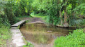
(S/E) With your back to the car park, take the path opposite that leads down into the valley. At the first junction, continue straight down. Cross the Véronne via a small bridge and, after a slight climb, keep to the right and follow the river.
(1) Take the path on the left before the bridge; at the end of the uphill path, cross a road (take care) and head straight ahead onto Impasse de la Bigrerie. Take thefirst path on the right and continue to a T-junction.
(2) Head down the forest track to the right, pass the source of the Siverie and walk up the ravine to a small road.
(3) Follow it to the right and carry on straight ahead, ignoring the path and the road on the left. Pass close to the source of the Véronne, the Fontaine Rémy, then past the Church of La Poterie-Mathieu. Carry on tothe first path on the left.
(4) Turn sharply left onto the Sentier des Mières; at the top, turn right; at the Fork in the road, turn left and carry on until you reach a road.
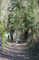
(5) Turn right onto this road (Chemin du Caillou Marais), then turn right onto the small grassy track. At the end of the cul-de-sac, turn left to head back down a lovely sunken path and rejoin a small road.
(6) Turn left onto the road (take care) which descends into the valley, then veer right onto the path that crosses the Véronne via a footbridge before climbing back up the other side.
(7) At the top, veer left to climb through the beech forest. Back on the Rue de la Creuse D98, head down to the left until you reach the exit, then turn right.
(8) Turn right onto a very steep and barely visiblesunken track whichleads out onto a small road.
(9) Follow it to the right (Route du Manoir du Vièvre) as far as the village. At the end, turn right onto the D98.
(10) Turn left onto Rue de l’Église to return to the car park (S/E).
 Visorando Member
 Moderate
  Tourist office