The Bisse du Ro, starting from Crans-Montana

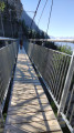
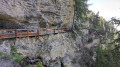
You’ll walk alongside what is probably the oldest bisse. Since 1947, as maintenance had become too dangerous, the water no longer flows through it; it has been diverted. The information boards along the path are well worth reading. The path can be quite impressive as you often follow a platform right in the middle of the cliff face, as shown in one of the photos. Of particular note is a Himalayan-style footbridge – wide but nonetheless impressive, 124 metres long – built in 2020. The route is very well secured. You can extend the walk to the Tseuzier dam and return by bus, or otherwise return via the same route.

Please note: given the terrain, the elevation gain shown is significantly overestimated. Expect around 150 metres.

Details

100204946
Creation:
Last update:
Last review:
  • Walking
    Activity: Walking
  • ↔
    Distance: 5.06 mi
  • ◔
    Average duration: 5h 00 
  • ▲
    Difficulty: Easy

  • ⚐
    Back to start: Yes
  • ↗
    Ascent: + 3,071 ft
  • ↘
    Descent: - 3,081 ft

  • ▲
    Highest point: 5,614 ft
  • ▼
    Lowest point: 5,131 ft

Photos

Description of the walk

From the centre of Crans Montana, follow signs for Plans-Mayens. On the “route de Plans-Mayens”, a sign points to the Cabane des Lys on the west-hand side of the road. Parking available. If not, continue down the route de Plans-Mayens to find another parking spot.

Another option: Access from the bus stop or the Beau Cèdre car park. Walk to (1)

(S/E) Head west and follow the yellow-marked path which passes in front of the refreshment kiosk and runs alongside the Bisse du Ro.

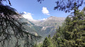
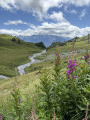
(1) At the junction (bench), continue straight on along the bisse. Further on, there’s a lovely view over the Liènne Valley and Lake Tseuzier. Ignore a path leading down to the left.

(2) Take a Himalayan-style footbridge to cross a ravine.

(3) On the other side, turn left and continue along the bisse (north, then north-east and finally north).

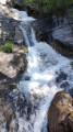
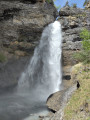
(4) Turn left and head down to a riverside picnic area (with a waterfall when the water is flowing strongly).

(5) Retrace your steps to the previous junction.

(4) There are two options for the return journey:
- Turn right and follow the path you took on the way there in the opposite direction back to the car park (S/E).
- Continue straight on towards the Tseuzier dam. Head up towards the Er de Chermignon and look for a bus stop (not shown on the map). Return to Crans-Montana by bus.

Waypoints

  1. S/E : mi 0 - alt. 5,197 ft - Car park – Cabane des Lys
  2. 1 : mi 0.39 - alt. 5,207 ft - Crossroads – Bench
  3. 2 : mi 1.39 - alt. 5,315 ft - Southern end of the - Passerelle du Bisse du Ro
  4. 3 : mi 1.46 - alt. 5,315 ft - Northern end of the - Passerelle du Bisse du Ro
  5. 4 : mi 2.46 - alt. 5,476 ft - Junction
  6. 5 : mi 2.5 - alt. 5,472 ft - Picnic area
  7. S/E : mi 5.06 - alt. 5,197 ft - Car park – Cabane des Lys

Notes

Long stretches of the route follow footbridges amidst vertical rock faces. This bisse is impressive but not recommended for those prone to vertigo. It is said to be the most acrobatically constructed canal amongst the many bisses of the French-speaking Valais.

In early spring or after heavy rain, and in autumn: check with the tourist office regarding the condition of the path. It is closed at certain times: in winter, etc.

Next to the car park, the Cabane des Lys is a charming spot with a refreshment bar and light meals. The terrace is sunny… in fine weather. Access is via a small road suitable for vehicles, although this isn’t clearly marked on the map.

After (4), there are toilet facilities followed by a picnic table.

From Crans to Le Tseuzier or vice versa: Car Postal (Lines 352 & 353) + Anzère Liberté shuttle bus

Worth a visit

Bisse du Ro: it used to rise in the Ertenze valley and flow down to Crans-Montana.

There are numerous information boards along the bisse.

Other walks in the area

For more walks, use our search engine .

The GPS track and description are the property of this route's author. Please do not copy them without permission.