The Elche Reservoir

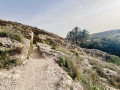
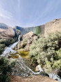
A very pleasant, easy walk suitable for the whole family along the River Vinalopo towards the Elche dam, or even beyond, offering views of an impressive waterfall some twenty metres high. The walk described here goes well beyond the dam, right up to a point where the owner of the farmland prohibits access, but this allows you to walk round the lake a little. As this is a round-trip walk, you can stop whenever you like.

Details

18934377
Creation:
Last update:
Last review:
  • Walking
    Activity: Walking
  • ↔
    Distance: 7.60 mi
  • ◔
    Average duration: 3h 40 
  • ▲
    Difficulty: Easy

  • ⚐
    Back to start: Yes
  • ↗
    Ascent: + 236 ft
  • ↘
    Descent: - 233 ft

  • ▲
    Highest point: 584 ft
  • ▼
    Lowest point: 377 ft

Photos

Description of the walk

The starting point for this walk is in the car park at Pantano de Elche (the Elche reservoir). To get to this starting point by car, see the ‘Practical Information’ section below.

(S/E) Go through the car park entrance gate, head left towards the River Vinalopo and you’ll arrive at the foot of the dam.

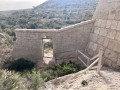
(1) Head towards the steps on the right to continue along the path. Climb a short way up to reach the top of the dam and enjoy a view of the lake. Continue along the path.

(2) You’re now on a footbridge over the water. You can end the walk here if you wish.
But carry on a little further to explore the whole water supply system, and even a few aqueducts.

(3) Take a small path on the left. Contrary to what it looks like on the map, you aren’t actually walking on the water! There is indeed a very narrow dirt track which, running through the reeds, will take you to the other side. It’s great fun to try this safe crossing.

(4) You arrive at a property, a vast orange grove. The owner forbids access to his land (no doubt he’s fed up with people constantly stealing his oranges?). This is why the route ends here.

Turn round and follow the same route back along which you came to return to the car park where you set off (S/E).


Waypoints

  1. S/E : mi 0 - alt. 400 ft - Car park
  2. 1 : mi 0.83 - alt. 449 ft - Dam
  3. 2 : mi 0.88 - alt. 495 ft - Footbridge.
  4. 3 : mi 2.68 - alt. 528 ft - Junction.
  5. 4 : mi 3.8 - alt. 541 ft - Road closed.
  6. S/E : mi 7.6 - alt. 400 ft - Car park

Notes

By car, from Alicante city centre, take the A31 motorway (from Calle México) towards Madrid, then take exit 235B onto the A70 towards Murcia/Aeropuerto/Elche. Continue on the AP7.
Take exit 518 towards the CV 84 towards Elche and Aspe.
Keep right towards the CV 84 towards Elche and Aspe.
On the CV84, at the roundabout, take the first exit (i.e. turn right).
At the junction, turn left onto Camino de Los Magros.
At the roundabout, take the first exit onto Camino de Los Magros.
Stay in the right-hand lane. You’ll start to see a sign pointing to our starting point, ‘Pantano de Elche’.
At the end of the road, go straight on to enter the Pantano de Elche car park and park there.

No water source.

Worth a visit

The Elche reservoir is a pioneering structure, as it was the first arch dam built in Europe. It is 23 metres high and 62 metres wide.
Historically, the first dam was built on this site in 1589 and was used for human consumption as well as for irrigating crops in Elche.
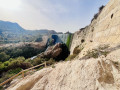
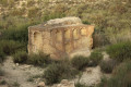
Along the walk, you can see the water diversion channel and a number of aqueducts.

Reviews and comments

4.7 / 5
Based on 2 reviews

Reliability of the description
5 / 5
Ease of following the route
5 / 5
Route interest
4 / 5
aicragellebasi
aicragellebasi

Overall rating : 5 / 5

Date of your route : Nov 14, 2025
Reliability of the description : ★★★★★ Very good
Ease of following the route : ★★★★★ Very good
Route interest : ★★★★★ Very good
Very busy route : Yes

A route that passes through an area of great geological and historical interest.
There are many possible variations, here are a few examples:

  • Start from Elche at the Molí Real and follow the white and yellow marked trail called Sender medioambiental riu vinalopo-entorn del panda d'Elx (8 km trail - alley).
  • Continue after crossing the river to the "Puente de hierro"
  • Instead of going along the lake shore, take the "senda del castillar" to the right of the dam, which climbs 300 metres and offers breathtaking views of Elche, the dam and the entire valley behind, passing by the archaeological site "El Castellar de la Morera".

There are many other paths to explore if you like to venture off the beaten track...

Machine-translated

pjaupain
pjaupain

Overall rating : 4.3 / 5

Date of your route : Apr 22, 2024
Reliability of the description : ★★★★★ Very good
Ease of following the route : ★★★★★ Very good
Route interest : ★★★☆☆ Average
Very busy route : Yes

A lovely family walk, but a bit crowded (it was a Sunday)

Machine-translated

Other walks in the area

For more walks, use our search engine .

The GPS track and description are the property of this route's author. Please do not copy them without permission.