The Fouzon Valley

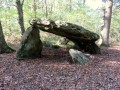
A pleasant walk through unpretentious countryside; do visit the Cocu Dolmen and the twisted bell tower at Saint-Outrille.

Details

591693
Creation:
Last update:
Last review:
  • Walking
    Activity: Walking
  • ↔
    Distance: 9.70 mi
  • ◔
    Average duration: 4h 45 
  • ▲
    Difficulty: Moderate

  • ⚐
    Back to start: Yes
  • ↗
    Ascent: + 285 ft
  • ↘
    Descent: - 282 ft

  • ▲
    Highest point: 482 ft
  • ▼
    Lowest point: 312 ft
  • ⚐ Country: France
  • ⚐ City: Saint-Outrille (18310)
  • ⚑
    Start/End: N 47.143908° / E 1.840823°
  • ❏
    IGN map(s): Ref. 2123SB, 2124SB, 2223SB, 2224SB
  • Hour-by-hour weather

Description of the walk

Park at Place de l’Église de Saint-Outrille.
(S/E) Follow Rue de l’Écheneau and cross the River Fouzon. Continue along Rue Creuse until you reach the crossroads.

(1) Turn left onto Rue de La Belle Croix, follow this road and pass the hamlet of Avexi.

(2) After the hamlet, turn right onto the path leading uphill. Keep to the path on the left, which heads towards the hamlet of Rinciou.

(3) On reaching Rinciou, take the path on the left (do not join the road) and continue straight on along the north-westerly path. Keep well to the left and you will reach the hamlet of Pinçay.

(4) Pass through the hamlet, first turn right then left at the road leading down to Moulin de Bonveau, and follow the tarmac track that crosses the farm; do not head down into the valley.

(5) Continue along the footpath that runs alongside the road and carry on to the hamlet of Cocu.

(6) Follow the road which passes to the right of the farm until you reach the path on the left leading to the dolmen.

(7) Return to the road and continue left until you reach the next junction.

(8) Head back down into the valley along the small path on the left, pass Le Fouzon and reach the hamlet of Margot.

(9) Turn left and follow the path that runs alongside the river on your left. Carry on straight ahead, passing a road on your right, until you reach another road at a bend.

(10) Follow this road, leaving it at the next bend to take a new path.

(11) At the new road, carry on straight ahead, cross a bridge and pass the hamlet of Fontaine de Venet. Carry on, cross another road and cut across the road leading to Lavau.

(12) Cross another bridge and follow the same small road leading to Saint-Outrille.

(13) Follow Rue de Valançay, which leads straight to the church car park (S/E).

Waypoints

  1. S/E : mi 0 - alt. 348 ft - Place de l’Église. Cross the - Fouzon (cors d'eau) - Affluent du Cher
  2. 1 : mi 0.25 - alt. 394 ft - On the left, Rue de La Belle Croix
  3. 2 : mi 1.22 - alt. 367 ft - Dirt track on the right
  4. 3 : mi 1.72 - alt. 482 ft - Turn left before Le Rinciou
  5. 4 : mi 3.07 - alt. 459 ft - The hamlet of Praincay
  6. 5 : mi 3.33 - alt. 449 ft - Path continuing from the road
  7. 6 : mi 4.47 - alt. 410 ft - Road to Cocu
  8. 7 : mi 4.82 - alt. 400 ft - Cocu Dolmen
  9. 8 : mi 4.94 - alt. 358 ft - Path on the left
  10. 9 : mi 5.18 - alt. 315 ft - A place called Margot
  11. 10 : mi 6.47 - alt. 338 ft - Road opposite
  12. 11 : mi 6.84 - alt. 344 ft - Road opposite leading to a bridge
  13. 12 : mi 8.34 - alt. 348 ft - Bridge
  14. 13 : mi 9.46 - alt. 361 ft - Entrance to Saint-Outrille
  15. S/E : mi 9.7 - alt. 348 ft - Place de l’Église

Notes

No water source
I must admit that the return journey is a bit of a slog along dirt tracks through the fields (take care in hot weather – there’s no shade)

Worth a visit

Reviews and comments

4.7 / 5
Based on 2 reviews

Reliability of the description
5 / 5
Ease of following the route
5 / 5
Route interest
4 / 5
G20Rando
G20Rando

Overall rating : 5 / 5

Date of your route : Feb 27, 2023
Reliability of the description : ★★★★★ Very good
Ease of following the route : ★★★★★ Very good
Route interest : ★★★★★ Very good
Very busy route : No

Perfect!

Machine-translated

rambo18
rambo18

Overall rating : 4.3 / 5

Date of your route : Aug 20, 2018
Reliability of the description : ★★★★★ Very good
Ease of following the route : ★★★★★ Very good
Route interest : ★★★☆☆ Average

It was a lovely walk for a good half of the route, but the return journey was a bit monotonous, winding its way along the fields and, worst of all, in full sun! Thank you for letting us know.

Machine-translated

Other walks in the area

For more walks, use our search engine .

The GPS track and description are the property of this route's author. Please do not copy them without permission.