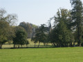
La Vigne route

Unfortunately, they have since disappeared, but in the 17th century, the region’s vineyards produced a wine of some renown. Madame de Sévigné, in fact, mentions it in several of her letters. Today, the only traces that remain are the names of local hamlets: Les Bourgeons, La Vigne, etc.
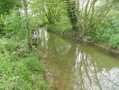
Over the final few kilometres, the route runs alongside the Quincampoix, a small river teeming with wildlife.
Vineyard Route No. 57 on the RANDO’ maps of the Vitré Community

Details

962576
Creation:
Last update:
Last review:
  • Walking
    Activity: Walking
  • ↔
    Distance: 8.96 mi
  • ◔
    Average duration: 4h 20 
  • ▲
    Difficulty: Moderate

  • ⚐
    Back to start: Yes
  • ↗
    Ascent: + 269 ft
  • ↘
    Descent: - 262 ft

  • ▲
    Highest point: 318 ft
  • ▼
    Lowest point: 171 ft
  • ⚐ Country: France
  • ⚐ City: Bais (35680)
  • ⚑
    Start/End: N 48.010198° / W 1.289866°
  • ❏
    IGN map(s): Ref. 1319SB
  • Hour-by-hour weather

Photos

Description of the walk

Park in the Bais car park, surrounded by shops, behind the church.

(S/E) Head south, going round the church via Rue des Tisserands, and turn immediately left into Rue du Docteur Lebreton. Very soon after, turn right into Rue de l’Abbé Pouchard, which continues as Rue des Hirondelles.

At the end of this street, first turn right then left, crossing the Chemin de Bel Air to join the Chemin de Chantereine. After passing the fitness trail on your left, take the path on the right. When you reach the riverbank, turn left and join a road.

(1) Follow the road to the left until you reach the hamlet of La Pichonnais. Continue to the right until you reach La Baillonnerie.

(2) Turn right, heading west. Cross the D95 and carry on straight ahead. When you reach Bas Moncel, veer to the right, heading northwards. Pass Belle-Isle.

(3) Turn left onto the path. Follow it round a bend to the left, then another to the right, and a second to the left, until you reach a T-junction.

(4) On the right, a short alternative route for the walk is signposted (not described here).
Turn left and follow the path round a bend to the right. At Champ Renou, take the road on the left and, after about a hundred metres, follow the path on the right heading south. Turn right at Pas Gagné, leaving the buildings of Villortay on your left. Follow the road round a bend to the right and head straight north.

(5) Continue to the left towards Le Bignon and carry on south-west.

(6) Be careful not to miss the path between the two fields on the left before La Coudre. Carry on round a bend to the right. Continue along the access road to the crossroads.
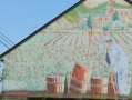
Note the painting on the gable of the house on the right, depicting work in the vineyards. Cross the road and carry on straight ahead.

(7) Leave the road and carry on straight ahead along the track; after 100 m, turn right. Continue along this track, which leads to the Lande.

(8) Turn right onto the road and, at the end of it, continue to the right onto the D110. Ignore the road on the left which leads to La Chaire.

(9) Continue along the track on the left 200 m further on. It makes a first turn left then a second turn right, heading due north before joining a road. Follow this road for 200 m to the right.

(10) Take the track on the left. Follow its twists and turns to reach the Route de la Touche Gillet. Continue to the right, heading due north, along this road until you reach the D37. Follow it to the right, crossing the bridge over the Quincampoix.

(11) Don’t miss the path on the right leading to the river. Continue along the path, keeping the crash barriers on your left, then turn right and cross the river. Follow the path as it winds along.

(12) If you have taken the alternative route, turn right.
Carry on along the river until you reach the Grande Abbaye.

(13) Turn left and cross the bridge. You’ll come out onto the D37. Follow it for 20 metres to the right, then take the path on the left which ends in Bais.

(14) Turn left, then right. Cross the main road and continue, keeping slightly to the right, along Rue de l’Écu. Go round the cemetery and continue to the right along Rue du Chanvre. When you reach the church, the car park is on the right (S/E).

Waypoints

  1. S/E : mi 0 - alt. 236 ft - Shopping centre car park
  2. 1 : mi 0.55 - alt. 190 ft - Turn left towards La Pichonnais
  3. 2 : mi 0.93 - alt. 276 ft - Turn right at La Baillonnerie
  4. 3 : mi 1.45 - alt. 210 ft - Path on the left after Belle-Isle
  5. 4 : mi 1.87 - alt. 223 ft - At the T-junction, turn left
  6. 5 : mi 2.92 - alt. 262 ft - Turn left towards Le Bignon
  7. 6 : mi 3.17 - alt. 276 ft - Path on the left before La Coudre
  8. 7 : mi 4 - alt. 253 ft - Go straight on to avoid Pré du Bois
  9. 8 : mi 4.49 - alt. 256 ft - At La Lande, take the road on the right
  10. 9 : mi 4.79 - alt. 269 ft - After 200 m on the D110, take the path on the left
  11. 10 : mi 5.69 - alt. 197 ft - Path on the left
  12. 11 : mi 6.61 - alt. 194 ft - Path on the right towards the - Quincampoix (rivière)
  13. 12 : mi 7.2 - alt. 174 ft - The alternative route joins the main route on the right
  14. 13 : mi 8.09 - alt. 180 ft - Bridge on the left at La Grande Abbaye
  15. 14 : mi 8.6 - alt. 233 ft - At La Villemais, turn left then right
  16. S/E : mi 8.96 - alt. 236 ft - Shopping centre car park

Notes

This route is signposted along its entire length by “Circuits du Pays de Vitré Communauté” signs featuring a Green Triangle and the number 57. In addition, you may come across yellow markers at certain changes of direction or to help guide walkers along the route.
The description above was written by “Le Randonneur Breton”.

(10) Alternative route: by continuing straight on for 50 m and then turning left, you will reach (12), saving 2.2 km.

Worth a visit

Reviews and comments

3.8 / 5
Based on 4 reviews

Reliability of the description
4 / 5
Ease of following the route
4.3 / 5
Route interest
3.3 / 5
montardoaran
montardoaran

Overall rating : 4.3 / 5

Date of your route : Feb 06, 2022
Reliability of the description : ★★★★★ Very good
Ease of following the route : ★★★★☆ Good
Route interest : ★★★★☆ Good
Very busy route : No

A very pleasant walk in the countryside.
Very few tarmac roads.
A good path running alongside streams
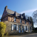
Pretty houses built from local stone.
Unpleasant odours from pig farms, but this section isn’t very long.

Machine-translated

Berlajat
Berlajat

Overall rating : 3 / 5

Date of your route : Feb 21, 2021
Reliability of the description : ★★★☆☆ Average
Ease of following the route : ★★★★★ Very good
Route interest : ★☆☆☆☆ Very disappointing
Very busy route : No

At point 4: a superb view of an industrial storage area for drainage pipes covering several hectares...
Afterwards, the route passes close to several industrial livestock farms (pigs, poultry, etc.) with a foul stench.
The Quincampoix must have been a very pretty river… in the past. It now carries the overflow water from a wastewater treatment lagoon belonging to a large industrial livestock farm.
In any case, it was very interesting to see the impact that certain industrial livestock farms have on the environment...

Machine-translated

guy35
guy35

Overall rating : 4 / 5

Date of your route : Aug 15, 2020
Reliability of the description : ★★★★☆ Good
Ease of following the route : ★★★★☆ Good
Route interest : ★★★★☆ Good
Very busy route : No

A lovely walk with plenty of footpaths and very few roads. The second section, near the stream, is more pleasant – cool and shaded – and ideal for a break.

Machine-translated

Laurence44810
Laurence44810

Overall rating : 4 / 5

Date of your route : Mar 04, 2019
Reliability of the description : ★★★★☆ Good
Ease of following the route : ★★★★☆ Good
Route interest : ★★★★☆ Good

It was a bit of a tricky start from the car park; the yellow markings had faded; the green markings for the Vitré region’s walking routes weren’t immediately visible. Otherwise, it was a pleasant walk through the countryside. The final few kilometres along the Quincampoix are very pleasant.

Machine-translated

Other walks in the area

For more walks, use our search engine .

The GPS track and description are the property of this route's author. Please do not copy them without permission.