Hambleden Hilly (Pheasant's Hill, Barn Wood, and Ridge Wood)

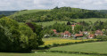
An interesting and varied circular walk exploring the valley and wooded hills to the north of Hambleden, the prettiest village in the Chilterns. The walk starts from the village car park adjacent to the Stag and Huntsman Inn; it follows mainly good paths, tracks, and rural lanes. With three significant hills, it offers some fine views of the Hambleden valley and is packed with interest. The Stag and Huntsman Inn at the end of the walk is perfect for refreshment.

This walk can be shortened to 4 miles (1 hill), or 6.3 miles (2 hills), should you prefer. Details are included in the description below.

Details

94948751
Creation:
Last update:
Last review:
  • Walking
    Activity: Walking
  • ↔
    Distance: 5.83 mi
  • ◔
    Average duration: 3h 20 
  • ▲
    Difficulty: Moderate

  • ⚐
    Back to start: Yes
  • ↗
    Ascent: + 781 ft
  • ↘
    Descent: - 781 ft

  • ▲
    Highest point: 518 ft
  • ▼
    Lowest point: 148 ft

Description of the walk

Start: Hambleden Village car park (pay-and-display) adjacent to the Stag and Huntsman Inn. Postcode: RG9 6RP. Grid ref: SU785865.

(S/E) Exit the car park and walk towards the church, passing by the Stag and Huntsman Inn and the old Wheelers Butcher’s shop on your left. At the road junction, turn right for 50 m and look out for a small gate on your left leading into the churchyard, opposite the Manor House (E).

(1) Go through the churchyard (church on your left) and exit through a gate. Turn right along the lane for 100 m to reach an iron kissing gate, just before the lane crosses the Hambleden Brook (B).

(2) Go through the gate and cross the meadow, following the grassy path up the valley (Chiltern Way).

The path passes through three more gates to reach a topiary hedge at Pheasant’s Hill - note the funny face which has been amusing walkers for decades!

Continue along the path between the hedges for 200 m to reach a cross path.

(3) Turn right (leave the Chiltern Way) up the hill and take the narrow path up between the cottages. Cross the lane and take the path bearing left up into the woods.

The path climbs steadily for 1.5 km (ignore other paths on the left and right) to reach the lane at Beeches Farm.

(4) Turn right along the lane, then immediately left onto a fenced footpath leading down the hill (west). Pass through a gate and continue downhill along the field edge on the grassy track. Views across the valley start to open up.

At the bottom of the field, the path turns right and descends through the woodland of Bagmoor Shaw to a lane. As you descend through the wood, note the grave on your right (C).

Go left along the lane, past The Hyde, for 200 m to reach a cross path (Chiltern Way).

(5) Turn left and follow the Chiltern Way for approximately 400 m to the lane at Colstope Fam (S).

[Option:For a shorter walk of 4 miles (and 1 hill) returning to Hambleden, keep straight ahead for 100 m past Colstrope Farm and take the footpath off to the left (as the road turns sharply right). Follow the path down the valley to Pheasant’s Hill (3) and retrace your way back to Hambleden.]

Continue ahead on the lane for 350 m, passing the farm and crossing the Hambleden Brook (B), to reach the main Hambleden Valley road.

(6) Cross the road (take care!) and go through the footpath gate opposite. The path bears left across the field to Bacres Farm. Continue ahead on the metalled drive which then turns right up the hill through Barn Wood.

After approximately 630 m the drive levels out and turns left (ignore track on right). At this point, continue ahead on the woodland path for a further 320 m to reach a dirt track.

(7) Turn left and follow the waymarks through the wood (ignore paths on left and right) to rejoin the metalled drive. Continue for 240 m to a junction of tracks. Turn left and cross the field (dirt track). As the track starts to descend, take the parallel woodland path on the right. After a short, steep descent the path joins a track (bridleway).

(8)
[Option: For a shorter route back to the village (5.75 miles and 2 hills), continue from Waypoint 8 ahead down to the road. Turn right (take care!) along the road for 300 m to a footpath gate leading around the meadow to the Hambleden Brook. Exit the meadow through another gate and go left along the lane. Go through the churchyard (church on your left) to the lych-gate and war memorial.]

To continue on the full route, turn right and follow the track as it climbs steadily up through Ridge Wood, with the valley sloping away to your left. In approximately 150 m the track forks – keep to the left.

Continue ascending along the track for approximately 20 minutes (1.25 km) to a path junction, just as the track starts to descend. Note: mid-way (600 m) along this track, look out for The Glade, an avenue of sequoia trees (E).

(9) At the path junction, take the path on the left downhill for 50 m, then left again and continue down to the road by the village. Cross the road (take care!) and follow the lane into the village centre (F).

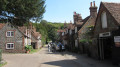
Pass the village shop and cafe (on the left) to the war memorial outside St Mary the Virgin Church (G). Continue past the old garage (on the right) and, at the road junction, continue ahead passing the old Wheeler’s Butcher’s shop, to return to the Stag and Huntsman Inn and car park.(S/E)

Waypoints

  1. S/E : mi 0 - alt. 157 ft - Start - Hambleden Village Car Park - Hambleden village
  2. 1 : mi 0.08 - alt. 167 ft - Churchyard Gate
  3. 2 : mi 0.19 - alt. 154 ft - Kissing Gate (Chiltern Way)
  4. 3 : mi 0.69 - alt. 187 ft - Cross Path
  5. 4 : mi 1.69 - alt. 518 ft - Beeches Farm
  6. 5 : mi 2.52 - alt. 210 ft - Cross Path (west of The Hyde)
  7. 6 : mi 3.11 - alt. 197 ft - Hambleden Valley Road
  8. 7 : mi 3.9 - alt. 449 ft - Path Junction in Wood
  9. 8 : mi 4.54 - alt. 279 ft - Path Junction (edge of wood)
  10. 9 : mi 5.37 - alt. 292 ft - Path Junction
  11. S/E : mi 5.83 - alt. 157 ft - Finish - Hambleden Village Car Park

Notes

Start: Hambleden Village car park. Postcode: RG9 6RP. OS Grid ref: SU785865.

Parking: Village car park adjacent to the Stag and Huntsman Inn. The car park is pay-and-display (if you choose to park elsewhere in the village, please do so responsibly).

Need to Know!

  • This route follows rural paths, tracks, and lanes. They may be rough or muddy in part.
  • Rural lanes/tracks that feature in the walk do not have footways. They are regularly used by walkers and horse riders, but please do take care!
  • You may encounter livestock in the valley meadows - keep dogs on short lead!
  • You are likely to encounter game birds on this walk (deer are also present) – keep dogs under close control at all times.

Refreshments :

Worth a visit

(A) Hambleden Manor - The flint and brick Elizabethan manor house to the east of the church was built in 1603 for Emanuel the 11th Baron Scrope, later Earl of Sunderland. King Charles I stayed here overnight in 1646 while fleeing from Oxford. The manor house was the birthplace of James Brundell, 7th Earl of Cardigan (1797 – 1868). He is remembered for leading the ill-fated charge of the Light Brigade during the Battle of Balaclava on 25 October 1854, during the Crimean War.

(B) Hambleden Valley and Hamble Brook - The Hambleden Valley and surrounding hills are in the Chilterns National Landscape. The valley cuts north to south through the chalk hills to the River Thames, sculpted by meltwaters during the Ice Age. The valley has long been occupied: flint tools evidence Neolithic occupation, remains of Roman settlement to the north and south of Hambleden village, and the village is recorded in the Doomsday Book of 1086. Today, the valley has a secluded, tranquil feel to it, characterised by rolling farmland and water meadows framed by the surrounding wooded hills.

The clear chalk Hamble Brook meanders along the valley bottom towards the River Thames. It is one of 9 major chalk streams in the Chilterns. Chalk streams are globally rare and a special quality of the Chilterns National Landscape. The stream is fed from groundwater stored in the chalk aquifer, which emerges as a spring near Skirmett (the next village up the valley). The Hamble Brook is a winterbourne (a stream which usually only flows in winter) relying on heavy rainfall to top up the aquifer and maintain the flow. It often dries up along parts of its course.

(C) The Grave in the Woods (not part of a Midsomer plot!) - The final resting place of Jane O'Leary (1927 – 2012), a long serving active member of the CPRE (The Campaign to Protect Rural England). Jane was a strong campaigner for the protection of pastures, hedgerows, woodlands and vernacular architecture, and she constantly fought to protect the countryside of the Hambleden Valley. She planted this wood in the 1960’s and worked to improve the flow of the Hambleden Brook.

(D) Colstrope Farm - a fine example of a mid-eighteenth century brick and flint farmhouse (Grade II listed building). It is a popular film and TV location and has featured, for example, in Poirot, Midsomer Murders, and Downton Abbey.

(E) The Glade - an historic avenue of Wellingtonia (Sequoia) trees, which appear to align with the church in Hambleden village.

(F) Hambleden village - The village name, Hambleden, is Anglo-Saxon in origin and means crooked or irregularly shaped hill. The village, with many flint and red brick buildings clustered around the church, is one of the prettiest in the Chilterns. As you stroll through the village, it is easy to see why it has become a popular location for filming. Films which feature the village include: The Captive Heart, Chitty Chitty Bang Bang, The Witches, The Legacy, Dance with a Stranger, Sleepy Hollow, the remake of The Avengers starring Ralph Fiennes, 101 Dalmatians, and Three Bags Full, a sheepish murder mystery starring Hugh Jackman and Emma Thompson. The village has also been a regular location for various TV series, including Band of Brothers, the Two Ronnies, Agatha Christie's Poirot, A Village Affair, Rosemary & Thyme, Endeavour, and Midsomer Murders.

During the build-up to D-Day in 1944, the village was a base for US troops.

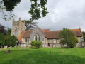
(G) St Mary the Virgin Church - The church dates from the 12th century. It originally had a central tower, but this was replaced by the current tower in 1721 (modified in the early 1880s). The tower holds eight bells, the oldest of which predates the Reformation. There is much of interest within the church, including:

  • The monument of Sir Cope D'Oyley (died 1633), his wife Martha and her ten children (note the children holding skulls who died before their parents);
  • The 12th century stone font and blocked ‘Devil’s’ doorway;
  • A carved wooden panel in the Wolsey Alter, said to be the remnants of Cardinal Wolsey’s bedstead; and
  • The munitions chest that belonged to Lord Cardigan (former Hambleden resident), infamous for leading the ill-fated charge of the Light Brigade.

In the churchyard is the domed Kenrick Mausoleum, and the grave of WH Smith (newspaper/bookseller), who became Lord Hambleden. His former house, ‘Greenlands’, is situated by the Thames near Mill End.

Other walks in the area

For more walks, use our search engine .

The GPS track and description are the property of this route's author. Please do not copy them without permission.