Circular Fort de la Turra from Lanslebourg

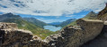
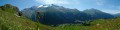
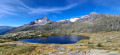
A superb hike through woodland and mountain pastures leading up to Fort de la Turra, which overlooks the Col du Mont-Cenis and the lake of the same name. The start is a bit challenging but offers a superb panorama. On the way back, you can enjoy the pastures on the opposite slope and the trails. It’s enough to make you want to put on your skis in winter.

Details

2386268
Creation:
Last update:
Last review:
  • Walking
    Activity: Walking
  • ↔
    Distance: 8.13 mi
  • ◔
    Average duration: 6h 55 
  • ▲
    Difficulty: Difficult

  • ⚐
    Back to start: Yes
  • ↗
    Ascent: + 3,645 ft
  • ↘
    Descent: - 3,615 ft

  • ▲
    Highest point: 8,159 ft
  • ▼
    Lowest point: 4,567 ft

Description of the walk

Park in the car park near the Turra ski lifts in Lanslebourg.

(S/E) Turn right onto theGR®5Eheading west, then quickly turn left off it to reach a crossroads with several routes.

(1) Take the path opposite, which climbs very steeply. Pass under the Turra chairlift. You’ll come to a crossroads at a bend in the Rapide Sentier.

(2) Take this path and, after a few hairpin bends, you’ll reach the hamlet of La Madeleine.

(3) Continue due west along the pastoral track. Ignore a path on the left. Leave the track to the left and take the path which, shortly afterwards, at a hairpin bend, turns 180° to reach a large crossroads above the Chalet Suiffet.

(4) Continue across the mountain pasture heading almost due south. You’ll reach Pont Bonneval.

(5) Cross the Madeleine Stream via the bridge. After two hairpin bends followed by a gentle climb, you’ll reach the Petite Turra pass.

(6) Turn left to reach the Old Fort de la Turra very quickly.

(7) Return to the previous junction.

(6) Start the descent on the left. After thefourth hairpin bend, you’ll reach a crossroads of footpaths.

(8) Here you have two options:
- continue along the path to reach the Col du Mont-Cenis, then turn left onto the road to reach the Mollard Crochet junction.
- Follow the route described here and take an animal track on the left to reach the Mollard Crochet junction directly.

(9) Follow the D1006 road and pass under the Ramasse chairlift.

(10) Turn left onto Chemin de la Ramasse and follow it to the Chardoux stream.

(11) Cross the stream, walk alongside the Pont des Chèvres chairlift and pass the Chapelle de la Madeleine before reaching the Turra car park (S/E).

Waypoints

  1. S/E : mi 0 - alt. 4,567 ft - Car park near the La Turra ski lift. Close to the - Arc (rivière) - Affluent de l'Isère
  2. 1 : mi 0.19 - alt. 4,793 ft - Crossroads with several directions
  3. 2 : mi 0.56 - alt. 5,308 ft - Rapide Crossroads Trail
  4. 3 : mi 1.84 - alt. 6,804 ft - La Madeleine
  5. 4 : mi 2.64 - alt. 7,185 ft - At the Chalet Suiffet
  6. 5 : mi 3.6 - alt. 7,687 ft - Bonneval Bridge
  7. 6 : mi 4.53 - alt. 8,100 ft - La Petite Turra
  8. 7 : mi 4.68 - alt. 8,159 ft - Old Fort of La Turra
  9. 8 : mi 5.49 - alt. 7,238 ft - Crossroads on the track
  10. 9 : mi 5.93 - alt. 6,650 ft - D1006 Mollard Crochet
  11. 10 : mi 6.3 - alt. 6,535 ft - La Ramasse chairlift
  12. 11 : mi 7.14 - alt. 5,318 ft - Chardoux Stream
  13. S/E : mi 8.14 - alt. 4,567 ft - Car park near the La Turra ski lift

Notes

(2) You can choose the level of difficulty and take the paths through the forest, or take it easy and follow the old road – though this will make the journey longer.
PS: We didn’t come across any proper water points, but there are plenty of streams. With a 1.5-litre CamelBak and an 800-ml water bottle, the two of us didn’t run out of water.
Note: A superb route for exploring the countryside: suitable for mountain bikes or e-bikes.

Worth a visit

Always be cautious and plan ahead when you're outdoors. Visorando and the author of this route cannot be held responsible for any accidents occurring on this route.

The GR® and PR® markings are the intellectual property of the Fédération Française de Randonnée Pédestre.

Reviews and comments

4.3 / 5
Based on 3 reviews

Reliability of the description
4 / 5
Ease of following the route
4 / 5
Route interest
5 / 5
Loucas_bn
Loucas_bn

Is this walk feasible in winter, given that it hasn’t snowed for a week?

Machine-translated

GillesetAnne
GillesetAnne

Overall rating : 3.3 / 5

Date of your route : Aug 14, 2023
Reliability of the description : ★★★☆☆ Average
Ease of following the route : ★★☆☆☆ Disappointing
Route interest : ★★★★★ Very good
Very busy route : No

We had a right struggle finding the path at the start (which we never actually found), which meant we ended up doing the route in the opposite direction to the description.
Same thing at the end of the route – we lost our way.
However, the views from the fort were superb and it was a really lovely walk, even though we ended up walking more kilometres than planned....

Machine-translated

Nicolas_73
Nicolas_73

I'd be happy to \ o /

Machine-translated

berenpapaye
berenpapaye

Overall rating : 4.7 / 5

Date of your route : Aug 27, 2021
Reliability of the description : ★★★★☆ Good
Ease of following the route : ★★★★★ Very good
Route interest : ★★★★★ Very good
Very busy route : No

It’s a pleasant walk through varied scenery, starting on a fairly steep but steadily ascending path that takes us quickly up into the cool of the forest.
At Fort de la Turra, the view over Lake Mont-Cenis is stunning.
The start of the descent from Petite Turra (point 6) is quite steep. I didn’t use the existing cables, but I was glad to have my walking poles. However, although I’m prone to vertigo, I wasn’t scared; this descent isn’t exposed and I don’t think it should put anyone off doing this walk.
I couldn’t find the path that takes you from point 8 to point 9 without walking along the road. So I walked down to the pass and took the road. This section isn’t very long.
Take care at point 9: the Chemin de la Ramasse starts before the chairlift of the same name! You need to turn left just after the cheese dairy and leave the track straight away to take the path on the right, which descends parallel to the D1006 road and passes a little further on beneath the Ramasse chairlift. You descend through the grass amongst the snow cannons before reaching the forest.
Thanks to Nicolas_73 for this lovely circular route!

Machine-translated

fberinger
fberinger

Overall rating : 5 / 5

Date of your route : Aug 23, 2021
Reliability of the description : ★★★★★ Very good
Ease of following the route : ★★★★★ Very good
Route interest : ★★★★★ Very good
Very busy route : Yes

A lovely walk. The section between points 6 and 7 is quite steep; there’s a cable to help with the ascent or descent, but it’s nothing complicated or dangerous. At point 8, we headed for the Col du Cenis, and it’s possible to take a shortcut across the meadows (to the left of the road, following cattle tracks downwards) to avoid walking along the road all the way to the Ramasse chairlift. However, we couldn’t find the path leading off from point 8.

Machine-translated

Nicolas_73
Nicolas_73

Hello,
It’s a shame this walk is all marked out – nothing special. As far as I can remember, I found it very easy to find the start and follow the route using the map.

Machine-translated

blondine
blondine

Hello everyone
I find it very difficult to follow the markings on a walk, even when I have the map right in front of me. I’d made notes of several walks but in the end I didn’t go on any of them because I lacked my bearings and found it a bit tricky to follow the map
Blondine

Machine-translated

Other walks in the area

For more walks, use our search engine .

The GPS track and description are the property of this route's author. Please do not copy them without permission.