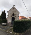
The fortified church of Mingoval, as seen from Aubigny-en-Artois

A lovely walk linking the market town of Aubigny-en-Artois – where you’ll find all the shops – to the charming village of Mingoval with its white-stone church, fortified tower and beautiful farmhouses. As the route reaches altitudes of over 150 metres in places, you’ll have views overlooking the surrounding villages – Savy-Berlette, Caucourt and the Scarpe valley, which is still narrow at this point.

Details

n°2125848
Creation:
Last update:
Last review:
  • Walking
    Activity: Walking
  • ↔
    Distance: 5.00 mi
  • ◔
    Average duration: 2h 30 
  • ▲
    Difficulty: Easy

  • ⚐
    Back to start: Yes
  • ↗
    Ascent: + 233 ft
  • ↘
    Descent: - 217 ft

  • ▲
    Highest point: 499 ft
  • ▼
    Lowest point: 295 ft

Description of the walk

Park in the car park near the church and the town hall in Aubigny-en-Artois.

(S/E) From the car park, turn right at the roundabout, walk behind the church over a small bridge spanning the River Scarpe, then turn left and immediately right, walking alongside the sports hall to reach the Chemin à l’Eau.

(1) Turn right and walk alongside the municipal stadium until you reach Rue de Cambligneul.

(2) Continue to the left, cross the level crossing and follow the D75 as it climbs up to a three-way junction just after the water tower.

(3) Then turn left onto the D75E3, which heads towards Villers-Châtel and is quiet. Pass under a power line and continue along this road. Enjoy the view ahead, to the right, of the woods surrounding Villers-Châtel Castle.

(4) In Villers-Châtel, at the town hall, turn left towards Mingoval onto the D73E2. Once in Mingoval, head down to the left towards the church, whose bell tower—dating from 1475—is crowned by a parapet walk from 1599 and topped with a stone spire whose crockets are carved with the heads of men or mythical creatures.

(5) Retrace your steps slightly and head down to the right along Rue Cagniart and, continuing on, Rue Volgan (offering a sweeping view of the Scarpe valley and the surrounding villages).

(6) Continue until you reach the junction with a dirt track running between the fields.

(7) Turn left onto this path and head for Aubigny-en-Artois. The path continues as a road that passes in front of the ‘Délices des 7 vallées’ shop and leads to the junction with the D73.

(8) Cross the D73 and follow the path opposite, which leads to Rue du Bourbon, where you can take a quick look – by walking a few steps to the left – at the site of the François-Xavier de Saulty care home, the main building of which dates from 1732. This is the hamlet known as ‘l’Abbaye’, as it was here that Saint Kilien, a monk of Irish origin, founded a priory in the 7th century to evangelise the region.

(9) Turn right onto the path leading to a pedestrian crossing over the railway line and cross Rue du Chemin à l’Eau

(1) Follow the same route back to the church car park (S/E).

Waypoints

  1. S/E : mi 0 - alt. 302 ft - Car park at the church in Aubigny-en-Artois - Église Saint-Kilien (Aubigny-en-Artois)
  2. 1 : mi 0.16 - alt. 302 ft - Junction on the Chemin à l’Eau
  3. 2 : mi 0.32 - alt. 299 ft - Rue de Cambligneul near the - Gare d'Aubigny en Artois
  4. 3 : mi 0.7 - alt. 361 ft - D 75E3 after the water tower
  5. 4 : mi 2.1 - alt. 499 ft - Villers-Châtel Town Hall
  6. 5 : mi 2.71 - alt. 449 ft - Mingoval Church
  7. 6 : mi 3.13 - alt. 456 ft - Viewpoint over the Scarpe valley
  8. 7 : mi 3.51 - alt. 361 ft - Junction on a dirt track
  9. 8 : mi 4.58 - alt. 348 ft - D73
  10. 9 : mi 4.78 - alt. 305 ft - Retirement home, on the site of the former priory
  11. S/E : mi 5 - alt. 302 ft - Car park at the church in Aubigny-en-Artois - Scarpe (rivière)

Notes

(4) You can take a short detour by turning right to visit Villers-Châtel Castle and its chapel.

All shops in Aubigny-en-Artois

Reviews and comments

3.8 / 5
Based on 2 reviews

Reliability of the description
4 / 5
Ease of following the route
4 / 5
Route interest
3.5 / 5
frimousse59
frimousse59
• Edited:

Overall rating : 3 / 5

Date of your route : May 02, 2024
Reliability of the description : ★★★☆☆ Average
Ease of following the route : ★★★☆☆ Average
Route interest : ★★★☆☆ Average
Very busy route : No

A short walk through the town and village, mainly on roads, so not ideal even though there weren’t many people about. The little village of Mingoval was lovely, though on the way back it was a real struggle to follow the route after passing the ‘Délices des 7 Vallées’ factory. Luckily, we’d made it back to the entrance to Aubigny. Not to be done in the blazing sun as there are few shaded areas. Just a quick note: as the church in Aubigny is undergoing renovation, you need to start the route 30 metres before it and take the footpath leading to the sports hall.

Machine-translated

immercurien
immercurien

Overall rating : 4.7 / 5

Date of your route : Jan 09, 2022
Reliability of the description : ★★★★★ Very good
Ease of following the route : ★★★★★ Very good
Route interest : ★★★★☆ Good
Very busy route : No

A ride enjoyed in fine weather.
A pleasant route with plenty of tarmac and few people about.
The railway level crossing is closed until 31 March 2022.
Thank you for sharing this.

Machine-translated

Other walks in the area

For more walks, use our search engine .

The GPS track and description are the property of this route's author. Please do not copy them without permission.