From the Loire Side Canal to the Château d’Estrées

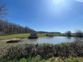
A pleasant walk along the Canal Latéral à la Loire near Le Molinet, exploring the surrounding countryside where the Châteaux d’Estrées and des Parisiens are situated. The landscapes in this area are varied, combining woodland, farmland and meadows where herds of cattle graze. The route, which follows good paths and quiet country lanes, is suitable for walking in all seasons.

Details

n°14469529
Creation:
Last update:
Last review:
  • Walking
    Activity: Walking
  • ↔
    Distance: 6.94 mi
  • ◔
    Average duration: 3h 20 
  • ▲
    Difficulty: Moderate

  • ⚐
    Back to start: Yes
  • ↗
    Ascent: + 203 ft
  • ↘
    Descent: - 203 ft

  • ▲
    Highest point: 896 ft
  • ▼
    Lowest point: 745 ft

Photos

Description of the walk

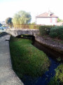
(S/E) Leave the Voie Verte car park by heading onto the Voie Verte along the Canal Latéral à la Loire and follow the canal north-west, moving away from the bridge where the D779 road, linking La Fontaine Saint-Martin to La Broche, crosses.

Almost immediately, there is a lovely view of the boat mooring on the other side of the canal, which has a motorhome area, a toilet and picnic tables (smaller car park). Continue along the Canal Latéral à la Loire, passing the hamlet of La Montagne.

Further on, admire an architectural curiosity: the canal bridge over the Vouzance, which the route crosses. There’s a lovely view of the surrounding countryside to the north, on your right. After passing the Domaine de l’Épine on your right, the route reaches a bridge over the canal.

(1) Continue straight ahead carefully along the road for about fifty metres before rejoining the Voie Verte path alongside the Canal Latéral à la Loire. This section becomes even more natural as it passes through a wooded area.

At the next bridge, turn left to pass by the hamlet known as Rio Chenet and reach the Route de Moulins (D779). Cross it with great care and follow it eastwards for about 50 metres, keeping to the grassy verge.

(2) Turn right onto a small road heading south, known as the Chemin de l’Invention. This is a former farm track, now tarmacked but with grass in the centre. The track climbs gently towards the Château d’Estrées (private property), which can be partially glimpsed during the ascent.
At the château, the route reaches a three-way junction.

(3) Turn right and, shortly afterwards, right again to follow a path heading westwards on a gentle descent. On the left, there are a few glimpses of the castle’s towers at the hamlet known as Les Parisiens. The path crosses a small stream flowing northwards towards the hamlet of La Micaudière before heading back up towards Les Thibots. There, the path becomes a small road and heads south-east towards the castle at the hamlet of Les Parisiens.

After passing the entrance to this property, the road descends towards a pond. Immediately afterwards, you’ll see a chapel on the right-hand side of the road, which marks the start of an ascent through woodland before reaching a crossroads on a slight downhill slope.

(4) Continue straight ahead on the road, which crosses a small stream with a pond on your left, before climbing up the side of the valley, passing through a farm. At this point, the road runs very close to a slip road linking the D994 to the N79-E 62.
At the top of the hill, before the hamlet of Les Buffets, turn left onto the small road heading north on almost level ground, before descending gently towards the hamlet of Estrées.

(5) At the crossroads just before the hamlet, you’ll see a wayside cross on your right. Turn right onto the small road leading downhill towards Fonfuble. At the next crossroads, just before the hamlet, turn left towards Les Lachets to the north. When you arrive there, by the pond on your left, take in the lovely view of Estrées Castle and its grounds. The road climbs slightly before reaching a junction with a track on the right.

(6) Turn right onto the Chemin du Génétrion, which soon descends to the hamlet, offering lovely views of the surrounding countryside towards the Fontaine Saint-Martin and Digoin further on.
At Le Génétrion, at a T-junction, turn left and follow the road on the left-hand side, running briefly alongside the River Vouzance before crossing Les Coudriers. The small road joins the D 79 at the hamlet known as Le Péage.

(7) At the crossroads, turn left and carefully follow the D 779, keeping to the left-hand side as the right-hand side is impassable due to a safety barrier for vehicles. Continue to the left-hand bend, then cross the road with great care just after the last house on the right. Go behind the safety barrier and walk across the grass along the Canal Latéral à la Loire towards the bridge situated about three hundred metres further west. Cross the canal via the bridge and return to the junction from the outward journey.

(1) As soon as you have crossed the bridge, turn right and follow the Canal Latéral à la Loire on your right-hand side, retracing your steps from the outward journey to return to the car park (S/E).

Waypoints

  1. S/E : mi 0 - alt. 761 ft - Voie Verte car park along the - Canal latéral à la Loire
  2. 1 : mi 1.14 - alt. 768 ft - Crossroads on the circular loop
  3. 2 : mi 1.8 - alt. 761 ft - Route de Moulins – path on the right
  4. 3 : mi 2.3 - alt. 846 ft - Paths to the west of the Château d’Estrées
  5. 4 : mi 3.46 - alt. 833 ft - Chemin des Parisiens – Chemin des Cadolles
  6. 5 : mi 4.43 - alt. 873 ft - Chemin d’Estrées – Chemin du Vieux Bourg
  7. 6 : mi 4.97 - alt. 823 ft - Chemin des Lachets – Chemin du Genetrion
  8. 7 : mi 5.56 - alt. 758 ft - Route du Moulin Momas – Route D 779
  9. S/E : mi 6.94 - alt. 761 ft - Voie Verte car park along the Canal

Notes

The car park is located at the Voie Verte car park beside the canal, below the bridge between Fontaine Saint-Martin and La Broche (on the La Broche side).

This walk across varied terrain requires suitable footwear.

This walk is not signposted, but there are no difficulties with navigation. Consequently, it is advisable to follow the directions in the description and on the map, whilst also paying close attention to the landscape. The waypoints (with their GPS coordinates and the distance from the starting point) serve as aids for walkers exploring the route for the first time.

Alternative route : Go directly from point (3) to point (5) by taking the road on the left and then turning right at the junction immediately afterwards. The route is then 8 km long.

Hike completed by the author on 11 October 2021.

Worth a visit

Molinet
A settlement dating from the Grand-Pressigny period. It fell under the jurisdiction of the castellany of Moulins. First mentioned in the 16th century in connection with a land exchange.
In 1848–1849, the authorities refused to grant the unanimous request of the municipal council, which sought to have the commune attached to the canton of Digoin and, thereby, to the department of Saône-et-Loire.
From 1940 to 1943, the demarcation line ran through Molinet. A sign indicating its route was erected in 2017 at the entrance to the village
Source: Wikipedia

The La Broche Pottery
The La Broche pottery was preceded, in 1770, by a glassworks that produced black glass bottles, fragments of which can still be found in the ground around the factory. The bottles were shipped by raft down the Loire. This factory operated until 1856, when it was bought by the Lemoine brothers. However, a clause in the sale contract prohibited the manufacture of glass bottles. The brothers therefore decided to produce stoneware (triangular hot-water bottles). Their choice was due to the fact that the raw material was available locally from the Guilloux quarry, on the road to Saint Léger, and they also received clay from Beaulon by boat.
In 1863, they sold the factory to Messrs Petitpierre and Perron; it was subsequently sold to Mr Escoffier, who significantly diversified its production. He ran the business until his death in 1918, after which his son-in-law, Mr Joseph Rousson, became Chief Executive of the Société Anonyme des Usines de la Broche. Mr Blanchardon, originally from Roanne, became managing director and expanded production and exports. Following his death, he was succeeded in 1939 by Félix Talbot, a talented lathe operator who had risen to the rank of foreman; he was supported by his son Claudius.
In 1949, Mr Maurice Rousson succeeded his father as Chief Executive, and in 1951, Mr Claudius Talbot took over from his father and became Managing Director. The factory became the Société Nouvelle de la Broche.
In 1960, the advent of plastic posed a serious threat to the factory, but as the manufacturing process was not yet fully developed, stoneware production regained its appeal. Mr Jacques Rousson was appointed Chief Executive Officer, replacing his uncle. And Mr André Talbot succeeded his father as managing director. The factory was modernised and managed to turn a profit. However, following new social legislation and the second oil crisis, the factory found itself in serious difficulty and was forced to close its doors in 1984.

Greenway: Loire Side Canal
Molinet is fortunate to be crossed by the greenway that runs from Dompierre to Digoin via Diou, Pierrefitte Coulanges and Digoin – a distance of nearly 30 km – along the towpath of the Loire Side Canal. This peaceful and particularly pleasant route allows you to discover six locks, canal bridges and other engineering structures associated with river navigation.

This section, which forms part of the route linking the Atlantic to the Black Sea, was developed by the Allier Departmental Council; it allows you to travel by the same means from Digoin to Paray-le-Monial (18 km) and from Gilly-sur-Loire to Bourbon-Lancy (12 km).
As you cycle, you’ll come across walkers – sometimes accompanied by their dogs – rollerbladers and, of course, anglers; these encounters will give you the chance to get to know the locals in this part of the Bourbonnais region, so close to Burgundy.

The Aqueduct Bridge
In Molinet, there is a structure that deserves a mention.
The aqueduct bridge, situated at a place called Le Péage – the little brother of the one at Digoin – consists of three arches.
Built between 1832 and 1835 by the engineer Émile Martin, this structure enables the Loire side canal to cross the River Vouzance.
When the structure was adapted to the Freyssinet gauge, the cast-iron trough, originally from the foundries at Fourchambault (Nièvre), was replaced by a masonry trough. Maintenance work was carried out in 1950–51 and 1954.
To explore it, take the cycle route between Molinet and Coulanges

The Château d’Estrées
The Château d’Estrées is situated on Route de Moulins, on the hills above Molinet.
A private property dating from the late 17th century, it is a magnificent building with a two-storey main block.
In May 1940, the German forces crossed the Loire and requisitioned this large house, which made an ideal barracks, ordering the owner to vacate the premises within 48 hours. Molinet found itself in the occupied zone; the demarcation line was nearby, with customs officers stationed at a place known as ‘Les Parisiens’.

The Chapel of Sainte-Radegonde (Off the main route)
On the road to Moulins, at the toll bridge, a path leads to the hamlet of Saint-Radegonde; it is here that you will find the chapel dedicated to Saint Radegonde.
In days gone by, a chapel stood on the banks of the River Loire, at the spot where Saint Radegonde is said to have stopped on her way to Lyon.
After it was destroyed by a flood, a new chapel was built at the end of the 17th century, sheltered from the river’s fury. Although built relatively late, the building’s overall style is Romanesque.
It is privately owned by the Cuissinat de Molinet family.

Source: the municipality’s official website

Reviews and comments

3.7 / 5
Based on 2 reviews

Reliability of the description
4 / 5
Ease of following the route
4.5 / 5
Route interest
2.5 / 5
User 21679240

Overall rating : 3.7 / 5

Date of your route : Sep 08, 2026
Reliability of the description : ★★★★☆ Good
Ease of following the route : ★★★★★ Very good
Route interest : ★★☆☆☆ Disappointing
Very busy route : No

Far too many tarmac roads

Machine-translated

patrouchkabol
patrouchkabol

Overall rating : 3.7 / 5

Date of your route : Jul 24, 2022
Reliability of the description : ★★★★☆ Good
Ease of following the route : ★★★★☆ Good
Route interest : ★★★☆☆ Average
Very busy route : No

A pleasant walk along the canal section, but a little monotonous in the countryside section. There is little shade along the route, so it is not recommended on very hot days.

Machine-translated

Other walks in the area

For more walks, use our search engine .

The GPS track and description are the property of this route's author. Please do not copy them without permission.