Country:

 City:
City:


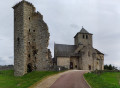
Park in the car park by the church in Saint-Hilaire-Peyroux.
(S/E) Cross the main road and take the street opposite. At the second junction, turn right into the street. Continue along a wide, downhill path through the woods.
(1) At the junction, continue left along the path, cross the stream and start climbing.
(2) When you reach the road, follow it to the left, then take the first path on the right. At the junction, turn left and continue uphill, before beginning the descent towards the Corrèze. Follow the pink markings carefully.
(3) When you reach the D141E2 road, turn right onto it and follow the banks of the Corrèze; on this stretch, there are picnic tables where you can stop for a break. It is also possible to park here and start the walk from the lowest point.
(4) Continue to the junction.
(5) Follow signs for Dessas, taking thethird road on the right uphill.
(6) At the junction, take the road on the left. Walk through the village of Dessas, then head downhill along the road.
(7) After the first bend, a path offers an alternative route to shorten the walk. This alternative route joins the (11) via a path not shown on the map. Continue along the road downhill.
(8) After the hamlet known as “Les Meydiaux”, take the road leading uphill to the right towards “Les Médiaux”. Pass the quarry on your left and take the first path leading uphill to the left. The path passes above the quarry. At the junction, continue to the left. The path joins the road as you reach the hamlet of Fougères.
(9) Turn right onto the road and turn right again at the next junction.
(10) Take the first path on the right and follow the pink markings.
(11) The alternative route joins this point on the right. Continue to the village of Saint-Hilaire-Peyroux. In the village, return to the starting point at the foot of the church (S/E).


 Visorando Member

 Easy
Easy