From Saint-Martin-de-la-Porte to Serpolière

A walk through woods and vineyards, very pleasant in spring or autumn for observing the flora and fauna.

Details

396724
Creation:
Last update:
Last review:
  • Walking
    Activity: Walking
  • ↔
    Distance: 3.82 mi
  • ◔
    Average duration: 2h 10 
  • ▲
    Difficulty: Easy

  • ⚐
    Back to start: Yes
  • ↗
    Ascent: + 492 ft
  • ↘
    Descent: - 489 ft

  • ▲
    Highest point: 2,533 ft
  • ▼
    Lowest point: 2,303 ft

Photos

Description of the walk

Car park near the local school.

(S/E) The route starts behind the local school in Saint-Martin-de-la-Porte, where there are a few parking spaces. Head towards Les Collombs along the road. After the wash house and the iron cross, take the small path that runs alongside the houses, heading down to the right. At the end of the path, follow the Ruisseau Saint-Bernard.

(1) Cross the bridge and walk a few metres uphill, then turn left onto the path almost directly opposite the previous one (a bridge used to stand a little further up but was swept away by the stream during a storm).
Continue along the main path, ignoring the paths branching off to the right and left.

(2) You’ll come out onto a dirt track which you follow down for about 250 metres until you find a new path that climbs slightly to the right

(3). Follow this path, passing a new iron cross before reaching a dry stream – hence its name: the Rieu Sec.

(4) Descend into the stream bed and climb back up the other side. Continue along the path, which gradually widens, ignoring the tracks branching off to the left, until you reach the Chapel of Sainte-Anne, built in 1598.

(5). Go round the chapel on the left and take the path on the right. Pass the Saint-Claude Oratory and then enter the hamlet of Serpolière, where the path becomes a road. Walk through the village for 400 metres.

(6) Take the path that descends to the left at a concrete cross. Along the way, you can see the old houses of the people who used to work in the vineyards; these have been restored since 2009 thanks to a local association.

(7) At the junction, turn onto the path on the left which passes through the vineyards and climbs gently up to the Chapel of Sainte-Anne.

(5) Return to the path you took on the way there, which heads left into the forest.

(4) Cross the dry stream again, follow the dirt track uphill and rejoin the path at the first hairpin bend, where there is a sign about the mountain flora and fauna.

Cross the Saint-Bernard stream once more, follow the path and the road to return to the starting point at Saint-Martin-de-la-Porte (S/E).

Waypoints

  1. S/E : mi 0 - alt. 2,484 ft - Car park near the local school
  2. 1 : mi 0.26 - alt. 2,441 ft - Bridge
  3. 2 : mi 0.51 - alt. 2,431 ft - Dirt track
  4. 3 : mi 0.67 - alt. 2,346 ft - Path on the right
  5. 4 : mi 1.05 - alt. 2,402 ft - Rieu Sec
  6. 5 : mi 1.27 - alt. 2,362 ft - Sainte-Anne Chapel
  7. 6 : mi 1.75 - alt. 2,533 ft - Path to the concrete cross
  8. 7 : mi 2.1 - alt. 2,303 ft - Path on the left towards the chapel
  9. S/E : mi 3.82 - alt. 2,484 ft - Car park near the local school

Notes

Make sure you wear trainers at the very least.
Water points: wash house near the local school in Saint-Martin-de-la-Porte

Worth a visit

You may spot ibex depending on the season.

Reviews and comments

4.2 / 5
Based on 3 reviews

Reliability of the description
4 / 5
Ease of following the route
4.3 / 5
Route interest
4.3 / 5
Promeneur Laurentin
Promeneur Laurentin

Overall rating : 5 / 5

Date of your route : Jul 25, 2026
Reliability of the description : ★★★★★ Very good
Ease of following the route : ★★★★★ Very good
Route interest : ★★★★★ Very good
Very busy route : No

More of a stroll than a hike, the route winds through the forest and vineyards
The route is well signposted today and easy to follow. There are even information boards about the local flora and fauna.
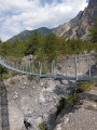
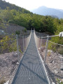
At point No. 4, you no longer have to go down into the stream bed as there is a Himalayan suspension bridge.

Machine-translated

Netra
Netra ★

Hello Yves, and thank you for your comments.

Is the ‘Average’ rating you gave to both the description and the route map due to the lack of signposts on site – for which neither the author nor Visorando are responsible – or is it because of an unclear description and an imprecise route map, which we could then try to improve based on your suggestions? Thank you in advance.

Machine-translated

yvesclaudealbert
yvesclaudealbert

Overall rating : 3.7 / 5

Date of your route : Sep 09, 2019
Reliability of the description : ★★★☆☆ Average
Ease of following the route : ★★★☆☆ Average
Route interest : ★★★★★ Very good

A lovely 2-hour walk where you pass through a charming little hamlet, but there are no signposts – a shame

Machine-translated

gigidiable
gigidiable

Overall rating : 4 / 5

Date of your route : Jun 03, 2017
Reliability of the description : ★★★★☆ Good
Ease of following the route : ★★★★★ Very good
Route interest : ★★★☆☆ Average

A short, fairly easy walk. A lovely walk through the woods.

Machine-translated

Other walks in the area

For more walks, use our search engine .

The GPS track and description are the property of this route's author. Please do not copy them without permission.