Country:

 City:
City:



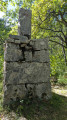


Park at the Marches cemetery, Chemin de la Placette.
(S/E) Opposite the cemetery, turn right towards the Plaine des Marches; after a right-hand bend followed by a left-hand bend, you’ll reach a crossroads.
(1) Turn right towards the hamlet of Murs. Once in the centre of the hamlet, first turn right then left and continue along Chemin du Champlong. Carry on straight ahead until you are directly beneath the high-voltage power line.
(2) Pass under the power line, rejoin the Chemin des Clayettes and turn right to reach the D1090.
(3) Cross the D1090 and then the D590a with care. Further on, turn right onto the D22 and continue for about 500 m until you reach a junction with Rue de Clessant.
(4) First turn left then right, and head up the Chemin du Montfollet. At the end, turn right, cross the bridge over the stream and follow the fairly steep path due north until you reach a fork in the road.
(5) Turn left and stay on this path, which joins the D285 near a bridge (on your left).
(6)Head right to walk alongside the road (take care), and cross the next bridge. Cross the road to join a path that climbs to the left towards the vineyards and then runs alongside them (to avoid the wide bend along the road). Return to the D285.
(7) Continue along it to the left, then keep to the right to walk straight through the hamlet of La Palud, and rejoin a stony path that climbs up to a shrine at a crossroads of paths.
(8) Carry on straight ahead, ignoring the paths to the right and left, and follow the signposts for Lac de la Puce, taking, after a few dozen metres, a shortcut on the left through the vineyards, heading due west. When you reach the Chemin des Essarts, turn left again then right; the path enters the forest. When it emerges, continue along the edge of the forest for about fifty metres.
(9) Turn left into the forest; after about 150 metres, the path turns south. Cross the first junction, then, after a 90° bend, reach the Martinons junction. Leave the hamlet on your left and turn right. After about a hundred metres, a path branches off to the left.
(10) This serves as a shortcut to rejoin the main route further up. Cross a wide track to the left and, immediately afterwards, reach another junction near the D285A.
(11) Follow the signpost for “Lac Noir – Lac de la Puce” to the right; stay on this forest track, which bends to the right and then leads to a car park (with a picnic area nearby).
(12) Continue all the way to the right towards Lac Noir.
(13) Turn left to walk round this small lake. At the junction (signpost), turn left towards north-north-east, continuing straight on along the Lac de Saint-André route, and keep going in this direction until the next junction.
(14) Turn right twice and take a small stony path that crosses the forest and emerges, over 1 km further on, beneath a high-voltage power line. Pass under the power line then follow the path as it winds alongside it for a few dozen metres before reaching a junction.
(15) Take the path on the left. Pass a path on your left, stay beneath the high-voltage line for several hundred metres before leaving it to the left and reaching a junction. Turn left until, some 200 m further on, you find a small path branching off to the right.
(16) Take this and rejoin a forest track. Turn right, pass thefirst turn-off on the left, take thesecond one shortly afterwards, go straight on at the next junction and reach the road near Lac Froment. Turn right, then immediately left to the south of the lake.
(17) Carry on straight ahead towards the east until you reach a T-junction. Turn left, heading north; at the Y-junction, continue to the right until you reach the first houses in Saint-André, via a small road (Chemin des Eygues) which runs alongside a stream on your left. You’ll reach the roundabout on the D12 near the Musée du Vigneron.
(18) Go round the roundabout on the right, then cross the Route du Lac de Saint-André (at the pedestrian crossing) and head uphill opposite. Turn right at the next junction, take the left-hand bend onto the Chemin du Gandy, leaving a road on your right, and continue to a crossroads (with a cross on your left).
(19) Turn right onto Chemin des Fromagets, cross the D12 and continue straight ahead to reach the shores of Lac de Saint-André.
(20) Walk along the eastern shore on the right-hand side; at a car park, turn right onto Chemin du Lac and continue until you reach a roundabout on the D12.
(21) Go round the roundabout on the left, follow the D12 on the left, passing the Ferme du Lac campsite, and you’ll reach a junction in the bend to the right of the road.
(22) Ignore thefirst left, take thesecond small road which climbs to the left (Chemin de Crincaille). This leads to a large roundabout (statue of the Virgin Mary on the right-hand side). Go round it on the right, then follow the edge of the meadow to return to the car park near the cemetery (S/E).
 Visorando Member
 Moderate
 Easy
Easy