From Saint-Pierre Church to the Gallo-Roman ruins of Tintignac

This “Nature and Heritage” walk, starting from Naves, mainly follows footpaths. It passes close to the historic site of Tintignac. Motorway noise is only noticeable in very limited areas.

Details

3061439
Creation:
Last update:
Last review:
  • Walking
    Activity: Walking
  • ↔
    Distance: 7.90 mi
  • ◔
    Average duration: 4h 20 
  • ▲
    Difficulty: Moderate

  • ⚐
    Back to start: Yes
  • ↗
    Ascent: + 817 ft
  • ↘
    Descent: - 820 ft

  • ▲
    Highest point: 1,673 ft
  • ▼
    Lowest point: 1,270 ft

Photos

Description of the walk

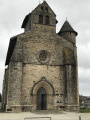
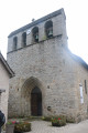
Park in the car park at Naves Town Hall next to Saint-Pierre Church.

(S/E) Head towards the school in the square and walk alongside it, veering to the left. Then keep to the right onto Rue du 19 mars 1962.

(1) After crossing the Vigne stream, take the path on the left which runs alongside it towards La Geneste.

(2) Just before reaching the La Geneste business park, at the ‘Cézarin’ sign, take the path leading uphill to the right towards Cueille. Cross the road at the pedestrian crossing on the right and take the road opposite to enter the grounds of the René Cassin agricultural college. Turn right after the entrance and continue until you reach the Route de Cueille (Rue de la Voie Romaine).

(3) Follow the road to the left, go over the motorway and take the first street on the left as you reach the hamlet.

(4) At the first junction, at the Cueille cross, follow the road to the left. Continue to the roundabout and go round it on the right before crossing the D53 at the pedestrian crossings. Walk about twenty metres to the right, then turn left towards Les Rochettes. Walk through the hamlet.

(5) Opposite a street on the right, turn left onto a path signposted for Tintignac. This poorly marked path runs alongside a field on its lower section as it climbs. Further on, it joins a road which you should follow straight ahead to cross the hamlet of Tintignac. On leaving the hamlet, continue along the path which descends towards Les Renardières and leads to the Route du Treuil.

(6) Take the road on the left which descends towards Les Renardières, leaving the Route du Treuil on your right. Leave the road at the first bend to take the path opposite, heading towards Monzauge. Follow the stream.

(7) Opposite the hamlet of Monzauge, take a path that climbs up to the left. Join the road at Les Bories, which are drystone shelters.

(8) Follow the road to the right towards Soleihavoup. Just before reaching the D1120, leave the road and take the path on the left which goes round a small housing estate.

(9) At the ‘Peuch Meja’ sign, continue straight ahead along the track. Leave the track in front of the ‘Champs’ sign to take a private passage that climbs to the right up to the road, and go through the tunnel underneath (the Boviduc). Join a small road.

(10) Turn left in a 180° turn, and carefully walk alongside the D1120 on your right towards the archaeological site. At the car park entrance, take a path not marked on the IGN map which climbs steeply. You’ll reach a road; follow it to the left to reach the archaeological site at Tintignac.

(11) At the rear of the site, turn right onto the path not marked on the IGN map towards La Geneste. Walk past the handball stadium on your right, then turn left onto the road to cross the bridge over the motorway. Walk a good hundred metres, then turn left towards La Geneste.

(12) At the junction before entering the hamlet, take the wide path on the left towards the La Geneste Business Park. Before reaching the first business, leave the main path and follow a track on the right that is not marked on the IGN map.

(13) Carry on straight ahead until you reach the road, cross it and follow the path opposite which runs down alongside the Ruisseau de la Vigne towards Naves.

(2) Carry on straight ahead, following the route back in the opposite direction to the outward journey.

(1) Turn right onto the road towards Naves to reach the church and the town hall car park (S/E).

Waypoints

  1. S/E : mi 0 - alt. 1,335 ft - Naves Town Hall
  2. 1 : mi 0.25 - alt. 1,329 ft - Common junction for outbound and return routes
  3. 2 : mi 0.72 - alt. 1,371 ft - Junction at the end of the circular loop
  4. 3 : mi 1.21 - alt. 1,444 ft - Route de Cueille, on the left
  5. 4 : mi 1.79 - alt. 1,483 ft - Croix de Cueille, on the left
  6. 5 : mi 2.51 - alt. 1,516 ft - Les Rochettes
  7. 6 : mi 3.2 - alt. 1,444 ft - Route du Treuil
  8. 7 : mi 3.98 - alt. 1,342 ft - Monzauge, path on the left
  9. 8 : mi 4.41 - alt. 1,539 ft - Drystone shelters
  10. 9 : mi 5.01 - alt. 1,493 ft - Peuch Meja
  11. 10 : mi 5.28 - alt. 1,555 ft - Le Boviduc, turn left (180°)
  12. 11 : mi 5.74 - alt. 1,611 ft - Tintignac archaeological site
  13. 12 : mi 6.54 - alt. 1,539 ft - La Geneste
  14. 13 : mi 6.98 - alt. 1,398 ft - Ruisseau de la Vigne, straight ahead
  15. S/E : mi 7.9 - alt. 1,339 ft - Naves Town Hall

Notes

The Naves area has numerous signposts marking the routes in addition to the trail markings. The trail markings are green for this route.

Worth a visit

Reviews and comments

3.8 / 5
Based on 3 reviews

Reliability of the description
3.3 / 5
Ease of following the route
4.3 / 5
Route interest
3.7 / 5
fanfan19240
fanfan19240

Overall rating : 4 / 5

Date of your route : Apr 17, 2023
Reliability of the description : ★★★★☆ Good
Ease of following the route : ★★★★☆ Good
Route interest : ★★★★☆ Good
Very busy route : Yes

a lovely walk

Machine-translated

philbalcou
philbalcou

Overall rating : 4 / 5

Date of your route : Sep 13, 2020
Reliability of the description : ★★★★☆ Good
Ease of following the route : ★★★★★ Very good
Route interest : ★★★☆☆ Average
Very busy route : No

A relatively long walk, with a real effort made to showcase the natural and historical heritage of Naves – there are plenty of small ‘culture and heritage’ signs along the route, which are a real help in places. You don’t see much of the archaeological site, at least not on a Sunday, even though you pass right by it at the end of the walk.
I found there were quite a few small tarmac roads on this route, and so out in the full sun – though it’s true that I did this walk under a blazing sun, which is rather unusual for September...
A couple of comments on the description:
- I had a bit of a city-dweller’s dilemma on stage 5. It’s very easy to find the start of the path: there really is a small sign pointing to Tintignac. Except that the path in question leads into a field, with a fine wooden fence topped with barbed wire, which I could certainly have opened and then closed neatly to cross the field (the path follows the edge of the field, but is actually within it), had it not been for a herd of cattle just behind it, including a magnificent bull, splendidly endowed by Mother Nature with all the masculine attributes befitting a bull’s life – which did little to tempt me to try my hand at being a bullfighter. As it happens, there is a second path leading off just behind it, marked by the wrong-way sign; I followed this second path for 300 metres; there is a small fork to the left, with a branch that briefly enters what is probably open farmland. You very quickly come across another path on the left, which you simply need to follow for 50 metres to reach the exit of the famous field and rejoin the hiking route. Thanks to the GPS tracking on the app!
- At (9), at the ‘Peuch Meja’ sign, the path heads off to the left and not straight ahead; that said, thanks to the small culture and heritage signs, there’s no confusion. However, I didn’t see the ‘champs’ sign further on, but I was easily able to find the way into another field (empty this time :-) ), with another small sign there. What’s more, there are small metal bridges set up to enter or exit the fields in this area along the route. You immediately come to the ‘boviduc’, which is very picturesque; it gave me the chance to take a photo of my dog, sitting in profile, silhouetted against the circle of light at the exit — you get the idea…

One last thing: I really do recommend making sure you don’t miss a chance to admire the interior of the church at Naves. The monumental altarpiece is quite simply breathtaking.

Machine-translated

lena19
lena19

Overall rating : 3.3 / 5

Date of your route : Aug 20, 2020
Reliability of the description : ★★☆☆☆ Disappointing
Ease of following the route : ★★★★☆ Good
Route interest : ★★★★☆ Good
Very busy route : No

A few difficulties that are inconsistent with the signposted route

Machine-translated

Other walks in the area

For more walks, use our search engine .

The GPS track and description are the property of this route's author. Please do not copy them without permission.