Marla - Cilaos

Third and final day in the Cirque de Mafate, heading back to Cilaos.

This walk is part of a multi-day hike: Cirque de Mafate

Details

9855
Creation:
Last update:
Last review:
  • Walking
    Activity: Walking
  • ↔
    Distance: 4.27 km
  • ◔
    Average duration: 2h 35 
  • ▲
    Difficulty: Moderate

  • ⚐
    Back to start: No
  • ↗
    Ascent: + 484 m
  • ↘
    Descent: - 819 m

  • ▲
    Highest point: 2,079 m
  • ▼
    Lowest point: 1,275 m

Photos

Description of the walk

(S/E) Head south towards Col du Taïbit via the sharedGR® R1 and R2 trails. Cross the pastures before tackling the fairly steep path. You’ll emerge at Col du Taïbit.

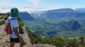
(1) Enjoy the view of the Cilaos cirque. Start the descent from the east to reach Source Ti Louis quickly.

(2) Continue along theGR®, leaving the path leading to the forest below the Trois Salazes on your left. Reach the Ilet des Salazes.

(3) Then begin the final descent, where the numerous hairpin bends lead onto the Ilet à Corde road (D242). Cross the road and walk down the D242 for a few metres to the left. There is a bus stop (E) for Cilaos town.

Waypoints

  1. S : km 0 - alt. 1,610 m - Marla
  2. 1 : km 1.46 - alt. 2,079 m - Col de Tabit
  3. 2 : km 2.51 - alt. 1,787 m - Ti Louis Spring
  4. 3 : km 3.61 - alt. 1,563 m - Ilet des Salazes
  5. E : km 4.27 - alt. 1,275 m - Bus stop D242

Notes

There are no water points on the trail.

Worth a visit

In Cilaos, don’t miss the Maison de la Broderie. Everything is handmade!
Pop into the thermal baths and try the hydromassage.
And above all, don’t forget to try the wine and lentils from Cilaos!

Always be cautious and plan ahead when you're outdoors. Visorando and the author of this route cannot be held responsible for any accidents occurring on this route.

The GR® and PR® markings are the intellectual property of the Fédération Française de Randonnée Pédestre.

Reviews and comments

4.7 / 5
Based on 5 reviews

Reliability of the description
4.4 / 5
Ease of following the route
4.8 / 5
Route interest
4.8 / 5
mig974
mig974

Overall rating : 5 / 5

Date of your route : Jul 07, 2025
Reliability of the description : ★★★★★ Very good
Ease of following the route : ★★★★★ Very good
Route interest : ★★★★★ Very good
Very busy route : Yes

A classic hike, a bit challenging for visiting the Cirque de Mafate when arriving from Marla.
The weather is often unpredictable in this area. It can change very quickly.

Machine-translated

bullit1344
bullit1344
• Edited:

Overall rating : 5 / 5

Date of your route : Aug 31, 2018
Reliability of the description : ★★★★★ Very good
Ease of following the route : ★★★★★ Very good
Route interest : ★★★★★ Very good

Machine-translated

Orando974
Orando974 ★

Overall rating : 4.5 / 5

Date of your route : Jun 20, 2018
Reliability of the description : ★★★★☆ Good
Ease of following the route : Not used / Not applicable
Route interest : ★★★★★ Very good

A brilliant hike! Stunning scenery. I’d recommend heading all the way to Trois Roches for the more fit (allow at least three hours there and back), as well as a guided tour of Îlet des Salazes if possible.

Machine-translated

Aurélie G4.
Aurélie G4.

Overall rating : 4.7 / 5

Date of your route : Jul 25, 2015
Reliability of the description : ★★★★☆ Good
Ease of following the route : ★★★★★ Very good
Route interest : ★★★★★ Very good

It’s a steep climb up to the Col du Taïbit, but it’s manageable; the path is in good condition at this time of year, and the final third is a bit less ‘strenuous’, but the views during the ascent and once at the summit are well worth the effort.
Mind you, watch out for mountain bikers coming down (yes, on their bikes, on the path): we came across some; they were very polite and let us pass, knowing full well that on a hiking trail, hikers have priority, but keep your eyes peeled, as they can take you by surprise...
The descent towards Cilaos isn’t too difficult: there are some fairly steep steps at the start and end of the descent (all the way down to the road for us) and a rather narrow section with a handrail just past the pass that might make the more sensitive among you feel a bit dizzy, but it’s a very pleasant walk down and the scents of the forest accompany you all the way.

Machine-translated

ponsin
ponsin

Overall rating : 4 / 5

Date of your route : Jan 16, 2014
Reliability of the description : ★★★★☆ Good
Ease of following the route : ★★★★☆ Good
Route interest : ★★★★☆ Good

Hello.
Yes, because I’m planning a fortnight’s hike on Réunion Island, but at the moment all the trails are closed by prefectural decree. Because of the cyclone.
So, watch this space.
Jean-Gilles.

Machine-translated

Other walks in the area

For more walks, use our search engine .

The GPS track and description are the property of this route's author. Please do not copy them without permission.