The Calvary Route in Ouroux-sur-Saône

On the edge of the Bresse and Chalonnais regions, Ouroux-sur-Saône is a vibrant village where market gardening and horticulture, linked to the Saône plain, continue to thrive. The village is crossed by the Voie Verte la Bressane cycle route, linking Chalon-sur-Saône to Lons-le-Saunier. It also boasts a wetland meadow where it is easy to spot birds.

Details

n°28403679
Creation:
Last update:
Last review:
  • Walking
    Activity: Walking
  • ↔
    Distance: 6.02 mi
  • ◔
    Average duration: 2h 45 
  • ▲
    Difficulty: Easy

  • ⚐
    Back to start: Yes
  • ↗
    Ascent: + 16 ft
  • ↘
    Descent: - 16 ft

  • ▲
    Highest point: 643 ft
  • ▼
    Lowest point: 617 ft

Photos

Description of the walk

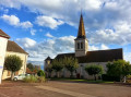
Car park located near the church. A sign showing the two ‘Balades Vertes’ routes in the town indicates the starting point of the walk.

(S/E) From the Church of Notre-Dame de l’Assomption, turn right onto Place de l’Église and then onto Rue du Bourgneuf, walking along the pavement, and pass in front of the town hall. Continue for 400 metres and veer slightly to the left opposite the chemist’s, still on Rue du Bourgneuf.

(1) Cross Rue de la Charme and continue straight ahead along Rue de Grancière.

(2) Turn into thefirst street on the right, Rue des Acacias. The tarmac road then turns into a stony track. Leave the track on your right after 500 m and carry on straight ahead. You are now in a woodland. In the middle of the woodland, you’ll come across the Voie Verte. Cross it and carry on straight ahead until you reach the next tarmac road.

(3) Turn right onto Rue de l’École, then take thefirst street on the left, Rue du Brouillat.

(4) Turn right onto thefirst dirt track. Keep to the right until you reach the next junction with a tarmac road.

(5) Turn left onto the Voie Verte la Bressanne. Cross the various junctions with care and follow the cycle path for 2 km. (Alternative route: Turn right after 1.5 km onto the Route du Rouilly. This shortens the walk by 2 km).

(6) Turn right onto thefirst gravel track and carry on straight ahead along the tarmac road, Rue de la Chaunée. Continue for 1 km, then follow Rue Chêne straight ahead for 50 m.

(7) Turn right onto Chemin du Bourg à Vélard.

(8) After 800 m, turn right onto Rue du Mont. Carry on and turn left onto Rue de la Cure.

(9) At the end of this street, turn right onto Rue Gaillard, then carry on to the church to return to the starting point (S/E).


Waypoints

  1. S/E : mi 0 - alt. 633 ft - Église Notre-Dame de l'Assomption (Ouroux-sur-Saône)
  2. 1 : mi 0.33 - alt. 633 ft - Rue de la Charme
  3. 2 : mi 0.53 - alt. 620 ft - Rue des Acacias
  4. 3 : mi 1.59 - alt. 640 ft - Rue de l’École
  5. 4 : mi 1.9 - alt. 633 ft - Junction onto a dirt track
  6. 5 : mi 2.87 - alt. 640 ft - La Bressane Greenway
  7. 6 : mi 4.21 - alt. 620 ft - Stony path
  8. 7 : mi 4.94 - alt. 627 ft - Chemin du Bourg in Vélard
  9. 8 : mi 5.43 - alt. 630 ft - Rue du Mont
  10. 9 : mi 5.91 - alt. 623 ft - Rue Gaillard
  11. S/E : mi 6.02 - alt. 633 ft - Église Notre-Dame de l'Assomption (Ouroux-sur-Saône)

Notes

The walk starts in the town centre, heading towards the church, with access to a car park near the shops. Trainers or light walking shoes are sufficient. This trail is signposted with directional signs (OUR1) and yellow painted arrows.

Worth a visit

The trail follows part of the Voie Verte la Bressane. It is also possible to join the trails at Saint-Christophe-en-Bresse or Saint-Germain-du-Plain. A detour via the meadows of Ouroux-sur-Saône is recommended, particularly during migration periods. At such times, it is possible to spot numerous birds without too much difficulty. The banks of the Saône, nearby, are also well worth a visit.

Reviews and comments

4.3 / 5
Based on 2 reviews

Reliability of the description
5 / 5
Ease of following the route
4 / 5
Route interest
4 / 5
OT Bresse Bourguignonne

Hello

Thank you for your very helpful comment.
We’re delighted that you were able to enjoy this walk and discover the autumn colours in the Burgundian Bresse.

Have a lovely day

Bresse Bourguignonne Tourist Office
Mélise

Machine-translated

User 31133489

Overall rating : 4.3 / 5

Date of your route : Oct 27, 2026
Reliability of the description : ★★★★★ Very good
Ease of following the route : ★★★★☆ Good
Route interest : ★★★★☆ Good
Very busy route : No

A very easy route through woods and fields
Perfect for less experienced walkers
Very clear route description
The only downside: at the end of the route, there are no signs to indicate Rue du Mont and Rue de la Cure. But the church tower is in sight

Machine-translated

OT Bresse Bourguignonne

Hello Rastarocket

Thank you for taking the time to leave a comment. We’re delighted that you had a lovely, peaceful and relaxing time on this walking route.

Have a lovely day

Bresse Bourguignonne Tourist Office
Mélise

Machine-translated

Rastarocket
Rastarocket

Overall rating : 4.3 / 5

Date of your route : Nov 20, 2022
Reliability of the description : ★★★★★ Very good
Ease of following the route : ★★★★☆ Good
Route interest : ★★★★☆ Good
Very busy route : Yes

An easy, relaxing walk alongside horses and an old railway line

Machine-translated

Other walks in the area

For more walks, use our search engine .

The GPS track and description are the property of this route's author. Please do not copy them without permission.