Paths of Remembrance in Vitry-le-François

To get to know your town better, here is a short walking route that will take you past the monuments marking all the places of remembrance in Vitry-le-François. This route, which winds through the town’s streets, presents no particular difficulty.

Details

8417210
Creation:
Last update:
Last review:
  • Walking
    Activity: Walking
  • ↔
    Distance: 3.43 mi
  • ◔
    Average duration: 1h 35 
  • ▲
    Difficulty: Easy

  • ⚐
    Back to start: Yes
  • ↗
    Ascent: + 7 ft
  • ↘
    Descent: - 7 ft

  • ▲
    Highest point: 344 ft
  • ▼
    Lowest point: 331 ft
  • ⚐ Country: France
  • ⚐ City: Vitry-le-François (51300)
  • ⚑
    Start/End: N 48.725118° / E 4.586396°
  • Accessible from the train station Gare de Vitry-le-François.
  • ❏
    IGN map(s): Ref. 2915E
  • Hour-by-hour weather

Photos

Description of the walk

Park at Place Royer Collard.

(S/E) Leave the square via its north-west corner and head for the Place d’Armes in Vitry-le-François. Make your way to the foot of the statue of the Goddess of the Marne, commonly known as ‘the Goddess’.

With your back to the statue, head towards the Caisse d’Épargne, then take Rue Aristide Briand opposite for 40 metres. Turn right into Rue du Mouton, where the Synagogue monument is located on the left, 100 metres further on, near the house at number 9.

(1) Turn left into Rue du Petit Denier, then continue straight on along Rue Jules Guesde. When you reach Place Maucourt, cross it diagonally to the right to reach the Souvenir Français monument. Then continue left along Boulevard du Colonel Dominé, then turn right into Rue de la Fauvarge and follow it to the end to arrive in front of the military cemetery where the National Necropolis is situated.

(2) Walk alongside the cemetery, turning left for 200 metres, then turn left onto Avenue de Toulouse. At the end, turn right onto Boulevard François 1er and continue to the roundabout approximately 400 metres away. Head left to see the newly installed bust of François 1er, the city’s founder.

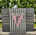
(3) Return to the roundabout, where you’ll see the war memorial, then continue straight on along Avenue de la République and follow this avenue to the SNCF railway station. A monument in honour of the deportees has been erected opposite the station and, right next to it, a memorial stone in honour of the martyrs of the Resistance.

(4) Cut across the car park behind the monument and head left onto Rue Nouvelle. At the traffic lights, turn right onto Avenue du Colonel Moll, then take the first street on the right, Rue Ferdinand Buisson
and, at the end of this street, cross at the pedestrian crossing and turn left onto Avenue de la République until you reach the roundabout. Then turn right onto Avenue Jean Jaurès and continue to the canal.

(5) Turn left onto Quai de la Faïencerie along the cycle path, go under the road via Chemin des Bateliers, then turn left onto Rue de la Citadelle. At the end of the street, turn right onto Rue du Vieux Port. As you pass, you’ll see the Gauloise war memorial, near the car park next to the sports hall.

(6) Turn left onto Quai du Canal, then turn left again onto Rue de la Glacière. Continue straight on until you reach the Town Hall, which is on your left: you can take a stroll through the park, where there is a monument in honour of Sadi Carnot, and rest on one of the benches provided.

Opposite the Town Hall, take Rue Dominé de Verzet, then turn left onto Rue de la Petite Sainte to reach Place Royer Collard and the car park (S/E).

Waypoints

  1. S/E : mi 0 - alt. 338 ft - Car park at Place Royer Collard
  2. 1 : mi 0.23 - alt. 331 ft - Rue du Petit Denier. Near the - Marne (la)
  3. 2 : mi 0.78 - alt. 331 ft - Nécropole nationale (Vitry-le-François)
  4. 3 : mi 1.38 - alt. 341 ft - War memorial
  5. 4 : mi 1.69 - alt. 341 ft - Gare de Vitry-le-François
  6. 5 : mi 2.34 - alt. 338 ft - Quai de la Faïencerie - Canal entre Champagne et Bourgogne
  7. 6 : mi 2.98 - alt. 341 ft - Canal Quay
  8. S/E : mi 3.43 - alt. 338 ft - Car park at Place Royer Collard

Notes

Sturdy shoes.
A bottle of water.

Worth a visit

On the Place d’Armes, admire the statue of the Goddess, which faces the Marne, and the Collegiate Church of Notre-Dame-de-l’Assomption.

Take in the various plaques and monuments dotted along the route, as well as the Necropolis, and admire the Town Hall.

Enjoy the gardens of the Town Hall (17th century), which feature several species of trees and flowers, as well as the remains of the former Récollets Convent; a monument has also been erected in honour of Sadi Carnot, who, in 1891, stopped in Vitry-le-François after conducting a military review in Matignicourt. During his visit to the town, he received a triumphant welcome.

During the war, the station served as an ‘evacuation hospital’.

Reviews and comments

5 / 5
Based on 2 reviews

Reliability of the description
5 / 5
Ease of following the route
5 / 5
Route interest
5 / 5
madam
madam

Thank you very much for your feedback

Machine-translated

marcheursduvendredi
marcheursduvendredi

Overall rating : 5 / 5

Date of your route : Feb 11, 2025
Reliability of the description : ★★★★★ Very good
Ease of following the route : ★★★★★ Very good
Route interest : ★★★★★ Very good
Very busy route : No

A lovely walk, alternating between the town centre and more open spaces (along the canal). Even though we live 30 km away, we made some interesting discoveries in the outlying neighbourhoods. We can’t recommend it highly enough.

Machine-translated

madam
madam

Thank you for your feedback

Machine-translated

marcheursduvendredi
marcheursduvendredi

A superb walk that we thoroughly enjoyed. We live just 30 km away, and yet we discovered new parts of the town.
Thank you for this very well-guided route.
The Friday walkers

Machine-translated

madam
madam

Hello,

That’s right, we could go via Rue du Pointis; I’m planning to include that street on another route as the Port de Plaisance isn’t a place of remembrance.
Thank you for your feedback

Machine-translated

Payster
Payster

Overall rating : 5 / 5

Date of your route : Jun 13, 2021
Reliability of the description : ★★★★★ Very good
Ease of following the route : ★★★★★ Very good
Route interest : ★★★★★ Very good
Very busy route : No

A brilliant city walk through a town often dismissed because it’s been rebuilt… it’s a shame, as there are still some surprising spots and the architecture is fascinating (a few remnants of half-timbered buildings, 19th-century town houses and ‘American-style’ reconstruction…)
Just one suggestion for improvement, perhaps: instead of taking Rue de la Citadelle between points 5 and 6, why not carry on along Rue du Pointis to reach the marina (a real gem!)?
Kind regards

Machine-translated

Other walks in the area

For more walks, use our search engine .

The GPS track and description are the property of this route's author. Please do not copy them without permission.