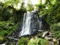
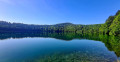
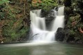
Vaucoux Waterfall (or Anglard Waterfall)

A short walk along a woodland path leading to the magnificent Vaucoux (or Anglard) Waterfall.

Details

61827632
Creation:
Last update:
Last review:
  • Walking
    Activity: Walking
  • ↔
    Distance: 0.53 mi
  • ◔
    Average duration: 0h 25 
  • ▲
    Difficulty: Easy

  • ⚐
    Back to start: Yes
  • ↗
    Ascent: + 207 ft
  • ↘
    Descent: - 207 ft

  • ▲
    Highest point: 3,386 ft
  • ▼
    Lowest point: 3,251 ft

Photos

Description of the walk

To get to the start point from Besse and Saint-Anastaise, take the D36 towards Compains. Enter the forest and head for the start of the path, signposted ‘Waterfall of Vaucoux’. There are a few parking spaces at the side of the road.

(S/E) Take the wide, downhill path until you reach a hairpin bend.

(1) Continue straight ahead along a narrower path until you reach the waterfall.

(2) After enjoying the scenery, return to the road (D36) via the same route you took on the way there (S/E).

Waypoints

  1. S/E : mi 0 - alt. 3,386 ft - The D36 road
  2. 1 : mi 0.11 - alt. 3,287 ft - T-junction
  3. 2 : mi 0.27 - alt. 3,333 ft - Cascade de Vaucoux ou Anglard
  4. S/E : mi 0.53 - alt. 3,386 ft - The D36 road

Worth a visit

Reviews and comments

5 / 5
Based on 2 reviews

Reliability of the description
5 / 5
Ease of following the route
5 / 5
Route interest
5 / 5
User 26681816

Overall rating : 5 / 5

Date of your route : Aug 20, 2025
Reliability of the description : ★★★★★ Very good
Ease of following the route : ★★★★★ Very good
Route interest : ★★★★★ Very good
Very busy route : Yes

Lovely walk, well-maintained trail and magnificent waterfall!... Easy to do with the family.

Machine-translated

augustins
augustins

Overall rating : 5 / 5

Date of your route : Mar 18, 2025
Reliability of the description : ★★★★★ Very good
Ease of following the route : ★★★★★ Very good
Route interest : ★★★★★ Very good
Very busy route : Yes

Good app

Machine-translated

Other walks in the area

For more walks, use our search engine .

The GPS track and description are the property of this route's author. Please do not copy them without permission.