Cascade de la Pisse

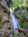
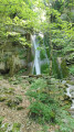
A short, refreshing walk leading to a cool waterfall hidden amongst the trees.

Details

36550923
Creation:
Last update:
Last review:
  • Walking
    Activity: Walking
  • ↔
    Distance: 3.60 mi
  • ◔
    Average duration: 2h 10 
  • ▲
    Difficulty: Moderate

  • ⚐
    Back to start: Yes
  • ↗
    Ascent: + 633 ft
  • ↘
    Descent: - 627 ft

  • ▲
    Highest point: 3,327 ft
  • ▼
    Lowest point: 2,707 ft

Photos

Description of the walk

The walk starts in Lalley, a small village in the Trieves region. Park in front of the town hall.

(S/E) With your back to the town hall, turn left onto Route de la Scie (D66), heading towards Men for about 150 m, until you reach thesecond road on the right.

(1) Follow this road towards the Belle Roche campsite. Walk alongside it on your right-hand side until you reach a three-way junction just after.

(2) Then take the path on the left that leads downhill. Continue along a wide path, sometimes in the sun, sometimes in the shade, until you reach a fork in the road after crossing the Pont de Ruelle.

(3) Turn left and carry on straight ahead until you reach a four-way junction.

(4) Turn right onto the path that climbs and follows the Ruisseau de la Pisse to a crossroads.
Listen to the murmur of the stream for the rest of the walk.

(5) Turn left to follow the stream along the opposite bank. The path now climbs quite steeply and follows the stream. Carry on straight ahead and cross the stream (be careful, as the ford isn’t very obvious). The waterfall is just behind it.

(6) You can have a picnic on the flat rocks in front of the waterfall.
The return journey follows the same route as the outward journey back to Lalley Town Hall (S/E).

Waypoints

  1. S/E : mi 0 - alt. 2,726 ft - Lalley Town Hall
  2. 1 : mi 0.09 - alt. 2,710 ft - Junction
  3. 2 : mi 0.38 - alt. 2,749 ft - Y-junction
  4. 3 : mi 0.79 - alt. 2,743 ft - Junction after the bridge
  5. 4 : mi 0.98 - alt. 2,707 ft - Rioux. Crossroads
  6. 5 : mi 1.42 - alt. 2,989 ft - Crossroads. Change of bank
  7. 6 : mi 1.8 - alt. 3,327 ft - Cascade de la Pisse
  8. S/E : mi 3.6 - alt. 2,726 ft - Lalley Town Hall

Reviews and comments

4.7 / 5
Based on 4 reviews

Reliability of the description
4.7 / 5
Ease of following the route
4.8 / 5
Route interest
4.8 / 5
Vivestido
Vivestido

Overall rating : 5 / 5

Date of your route : Jun 22, 2026
Reliability of the description : ★★★★★ Very good
Ease of following the route : ★★★★★ Very good
Route interest : ★★★★★ Very good
Very busy route : No

We went on this walk on a scorcher of a day, and it was really lovely as we were often walking in the shade; and when we had our picnic near the waterfall, we were almost feeling a bit chilly!

Machine-translated

User 18959112

Overall rating : 5 / 5

Date of your route : Aug 12, 2025
Reliability of the description : ★★★★★ Very good
Ease of following the route : ★★★★★ Very good
Route interest : ★★★★★ Very good
Very busy route : No

What a wonderful discovery!!!

Machine-translated

Bernandre
Bernandre

Overall rating : 4.3 / 5

Date of your route : Aug 11, 2025
Reliability of the description : ★★★★☆ Good
Ease of following the route : ★★★★☆ Good
Route interest : ★★★★★ Very good
Very busy route : No

surprising waterfall in this rather dry region between Vercors and Dévoluy

Machine-translated

sempervivum
sempervivum

Overall rating : 4.5 / 5

Date of your route : May 12, 2024
Reliability of the description : Not used / Not applicable
Ease of following the route : ★★★★★ Very good
Route interest : ★★★★☆ Good
Very busy route : Yes

A bit too much of a track for my liking, apart from the last section which leads up to a lovely waterfall (high flow following the rain, and two fords to cross). Ideal for a family walk, in the shade in summer

Machine-translated

Other walks in the area

For more walks, use our search engine .

The GPS track and description are the property of this route's author. Please do not copy them without permission.