Country:

 City:
City:


(S/E) The route is described starting from the car park in the centre of the village of Canfranc. Take the main street in Canfranc heading north.
(1) Turn right onto Calle del Fournil (Barrio del Hornero) to join the road running alongside the river (Río Aragón), and follow it upstream (to the left, therefore). At the very end, you’ll reach a small green space where a flight of steps leads back up to the main road at the bridge.
You should then walk carefully alongside the N330 for about 150 metres, on the right-hand side (as you go uphill), keeping a safe distance from the carriageway and, as far as possible, outside the crash barrier (there is a path suitable for this).
(2) When you reach a shed marked “MANCOMUNIDAD DEL ALTO VALLE DEL ARAGON”, you must cross the N330 with the utmost caution (heavy traffic). A small path opens up directly opposite. Follow it for about twenty metres, then head towards the river flowing just to your right (Aguaré ravine). If crossing the river proves difficult (due to high water levels), turn back as you’ll need to cross it again further upstream. Otherwise, join the signposted path (yellow and white) that runs alongside the river on the other side and follow it uphill (to the left). This path enters the forest and winds its way up in a series of hairpin bends with a steady gradient. You’ll come to a few junctions: be sure to follow the sign for ‘Barranco de Aguaré (clavijas)’.
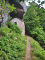
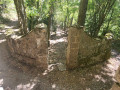
(3) You’ll come to a three-way junction, with a large dry-stone wall on the right. The path straight ahead (in the middle) is the correct one (marked by a cairn)! See photos. Further on, you’ll reach a junction with a path on the left, heading across the slope, and another on the right, going uphill (in switchbacks). You must follow the path on the left! Make sure to keep an eye out for the regular yellow and white markings. The traverse ends with a descent towards the river.
(4) Now is the time to cross the river. Look carefully for the markers on a large rock, which show you where to cross. Do not attempt to cross if the current is strong! After crossing, the path starts directly opposite (markers) and is quite steep.
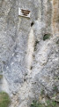
(5) The slope levels off and the path runs horizontally beneath the cliff… this is the big moment! A short rocky section awaits you, with footrests (clavijas) to place your feet on and chains (cadenas) for both hands. It’s fun and fairly easy. Best avoided if you suffer from severe vertigo, but otherwise it’s fine. Afterwards, the path winds through a shady pine wood.
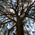
(6) You emerge from the woodland onto a sheep track (marked GR®11). We suggest you take a short detour to the left along this track to admire the Pino royo, a Scots pine over 300 years old (see photo)! Once you’ve done that, return to the junction and follow the pastoral track straight ahead across this pasture (Majada de Gabardito).
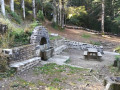
(7) Shortly afterwards, you’ll reach the Refugio forestal de Gabardito. There’s a table, benches and a fireplace, but no mattresses. Please take care of the facilities. Continue along the track for a further 100 metres.
(8) You must then turn left into the pasture, onto a small, poorly marked path, after a tree but before a dead fir tree (see photo). The path crosses the pastures almost level with the hillside. You’ll find markers at the entrance to a pine forest (see photo). From there, the path is better marked. You’ll walk alongside and cross an irrigation canal before joining the downhill path (which is still signposted). This path winds its way down in a series of hairpin bends, designed to keep the gradient gentle.
(9) At one of the hairpin bends turning to the left, you’ll spot a path branching off to the right. You can explore this area, where you’ll discover some impressive engineering structures designed to protect the village of Canfranc from floods and avalanches.
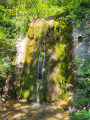
(10) You will eventually rejoin the track you saw earlier, but at a much lower altitude. Take the path opposite leading towards the village of Canfranc (signposted and marked as the GR®11). This path will take you past a spring in the rock (Fuente de la Pajeta, 1,230 m).
(11) After an easy but somewhat long descent, you’ll reach a series of terraces surrounded by walls. This is a nursery (vivero) which, over a century ago, was used to grow pine and fir trees that were later transplanted onto the hillside. All that remains is to head downhill… and rejoin the N330 main road.
(S/E) Cross the N330 carefully at the junction to return to your starting point.
 Visorando Member
 Easy
Easy 
 Moderate