A circular walk of challenge in Châteauvallon

Climb up via Le Gaz and descend via La Cramée – quite a challenge! That’s the route of this very short hike, which is nonetheless as gruelling on the ascent as it is steep on the descent. Not for those with weak knees… or, if you do go, be very careful.

Details

n°30307472
Creation:
Last update:
Last review:
  • Walking
    Activity: Walking
  • ↔
    Distance: 2.43 mi
  • ◔
    Average duration: 2h 00 
  • ▲
    Difficulty: Difficult

  • ⚐
    Back to start: Yes
  • ↗
    Ascent: + 1,004 ft
  • ↘
    Descent: - 1,004 ft

  • ▲
    Highest point: 1,381 ft
  • ▼
    Lowest point: 377 ft
  • ⚐ Country: France
  • ⚐ City: Ollioules (83190)
  • ⚑
    Start/End: N 43.147133° / E 5.873577°
  • ❏
    IGN map(s): Ref. 3346OT
  • Hour-by-hour weather

Photos

Description of the walk

Access to the hiking car park at Châteauvallon, west of Toulon, is very easy as the route to this area is always very well signposted, whether you’re coming from Toulon or Ollioules.

After an avenue with a central reservation lined with old olive trees, you’ll reach the large earthen car park overlooked by the theatre complex hidden beneath the pine trees. Drive to the end of this car park and park at its western end, at the starting point for the walks.

(S/E) Look straight ahead towards the north and take the small road that climbs up to the right towards the theatre car parks. Leave these car parks straight ahead and take the first hairpin bend on the left. At the start of this bend there is a barrier, near which, on the right, the start of the uphill path becomes visible. Use the bend in the road to rejoin this path further up, at one of the yellow plastic markers that line the gas pipeline route.

(1) Take the path which climbs very steeply northwards. Stay on this path, which varies considerably in condition and is often very rocky.

(2) Once you reach the highest point of this path, leave the gas pipeline track, which continues straight ahead through an area of earth embankment; you can see it descending and then rising again to cross the Détras track above: leave this earthen section and take the path that climbs to the right at a right angle.
This path leads just below the Détras track.

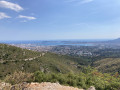
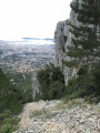
(3) A path branching off to the left would take you back to the track. Ignore it and carry on straight ahead: you are now on the Cramée path. After a short horizontal stretch running parallel to the track, a right-hand hairpin bend marks the start of the balcony-like descent towards the south, offering superb views of the Bonnes Herbes valley, the Bau de Quatre Ouro and, above all, the harbour of Toulon, straight ahead.

This path is by turns earthy, stony and rocky, but almost always steep.

Most of the descent takes place through the heath. On the final stretch, just before reaching the pine trees, the path runs along the top of a sort of very straight wall. It joins another path coming from the left at a right angle, from the Vallon des Bonnes Herbes.

(4) Turn right and stay on this path, which runs through the forest, more or less horizontally, first crossing a deep thalweg. Stay on the main path heading west until you reach the service buildings of the Châteauvallon theatre complex. Walk past a cylindrical building and take a road that overlooks the theatre car parks and joins the lower section of the ‘sentier du gaz’.

(1) Head back down to the left towards the starting car park (S/E).

Waypoints

  1. S/E : mi 0 - alt. 377 ft - Châteauvallon hiking car park
  2. 1 : mi 0.15 - alt. 446 ft - At the bottom of the gas pipeline path
  3. 2 : mi 0.77 - alt. 1,211 ft - Junction
  4. 3 : mi 0.96 - alt. 1,378 ft - Below the main track
  5. 4 : mi 1.66 - alt. 623 ft - Junction with the Bonnes Herbes route
  6. S/E : mi 2.43 - alt. 377 ft - Châteauvallon hiking car park

Notes

Please note that this route can be tricky on the descent along the Sentier de la Cramée. It is therefore essential to wear good walking boots and carry a pair of walking poles, and to take your time.

For those with knee problems, I would recommend heading up the track at point (3), following it to the bridge about 2 km to the east, and descending via the Vallon des Bonnes Herbes, which is an easy descent. At the bottom of the valley (after about 2.5 km of easy descent), turn right at a gate to rejoin the path that passes the point (4) and leads back to the starting point.

Worth a visit

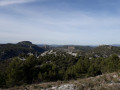
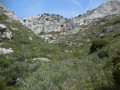
Whilst the first part of the route is of particular interest to keen walkers due to its long, very steep climb, the second part—which winds down in a series of terraces through very open countryside—offers a superb panorama throughout, set amidst heath teeming with the remains of terraced fields and the ruins of farm or shepherd’s huts. This barren landscape is the hallmark of nature reclaiming its rights following one or more fires on these slopes – hence, no doubt, the name ‘la Cramée’.

Pay particular attention to the view over Toulon Harbour, every detail of which is beautifully visible on a clear day.

You can also visit the Chateauvallon-Liberté theatre centre , a Scène Nationale, whose director is the engaging actor Charles Berling, who steered his theatre with great courage during the difficult lockdown period, much like a captain guiding his ship through a storm, without ever giving up.

Reviews and comments

4.7 / 5
Based on 1 review

Reliability of the description
5 / 5
Ease of following the route
5 / 5
Route interest
4 / 5
Magic mike
Magic mike

Overall rating : 4.7 / 5

Date of your route : Aug 21, 2023
Reliability of the description : ★★★★★ Very good
Ease of following the route : ★★★★★ Very good
Route interest : ★★★★☆ Good
Very busy route : No

This walk gets off to a challenging start with a steep climb. Doing it without walking poles can prove really tough.
Once you’ve completed the climb, you can enjoy the magnificent view over Ollioules Bay!
The descent isn’t exactly a walk in the park either; at times it’s just as steep as the climb. It’s slippery in places, so again, doing it without walking poles is still a bit tricky in my opinion.

A lovely walk that can be completed fairly quickly (it took me 1 hour 15 minutes).

Machine-translated

Other walks in the area

For more walks, use our search engine .

The GPS track and description are the property of this route's author. Please do not copy them without permission.