Circular route from Seignus Haut to La Valau, along the Verdon, in the Val d’Allos

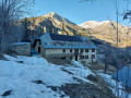
This circular walk in the Val d’Allos, starting from car park no. 1 at the Seignus Haut ski resort and descending to the Verdon before climbing back up to La Valau, can be done in any season on foot or with snowshoes. Alternatively, it can also be started from the Près or Saisonniers car parks in Allos, or from La Valau, on the banks of the Verdon.

Details

31023278
Creation:
Last update:
Last review:
  • Snowshoeing
    Activity: Snowshoeing
  • ↔
    Distance: 4.09 mi
  • ◔
    Duration according to the author: 2.5 hrs 
  • ▲
    Difficulty: Easy

  • ⚐
    Back to start: Yes
  • ↗
    Ascent: + 669 ft
  • ↘
    Descent: - 686 ft

  • ▲
    Highest point: 5,299 ft
  • ▼
    Lowest point: 4,649 ft

Photos

Description of the walk

Access by car: coming from Colmars-les-Alpes and after passing through Allos, turn left towards Le Seignus, cross the bridge over the Verdon, pass through the Seignus ski resort and continue to the Seignus Haut car park via the Route des Escassis. Park in the free car park on the right, before the no-entry sign.

(S/E) Walk through the hamlet along Rue du Seignus Haut, then turn left.

(1) Turn onto the Chemin de l’Adroit, then cross the ski runs with care and take the Route de la Rouine.

(2) Turn left to pass under the bridge on the Valcibière red run and head down Route de la Rouine towards the north-west until you reach a hairpin bend.

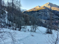
(3) Take a path on the left (visible on OpenStreetMap) and head down. At an altitude of around 1,490 metres, take a path on the right, then turn left along a stream that flows down to the Verdon.

(4) Turn left onto the path running alongside the Verdon and head upstream on the right bank to the Pont du Fanguet. Cross the footbridge to reach the left bank and head upstream along the Verdon to the Chemin de Premin.

(5) Cross the Pont de la Valau and turn left immediately below the farm to follow the right bank of the Verdon towards Allos. Some sections require a bit of care if you’re not wearing snowshoes and the snow is icy.

(4) Continue along the Verdon to Allos, passing under the Seignus road bridge until you reach a footbridge at a fork in the path.

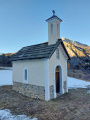
(6) Leave the footbridge on your left and follow a path that climbs to the right into the woods. After a few hairpin bends, you’ll reach the chapel and the hamlet of Les Guinands, below the Seignus cable car. Pass above Les Guinands and turn left to make your way up through the fields as best you can, finally joining the Route des Escassis (D26) at a hairpin bend.

(7) Follow this road to the left. At the first hairpin bend on the left, turn right into the fields below Seignus Haut and make your way up through the hamlet, crossing it to reach the Chemin de l’Adroit.

(1) Turn left, then continue right onto Rue du Seignus Haut to reach the car park (S/E).

Waypoints

  1. S/E : mi 0 - alt. 5,289 ft - Car park no. 1 at Seignus Haut
  2. 1 : mi 0.1 - alt. 5,289 ft - Junction of the circular loop
  3. 2 : mi 0.54 - alt. 5,184 ft - La Rouine hamlet – Snow-grooming vehicle car park
  4. 3 : mi 0.72 - alt. 5,108 ft - Route de la Rouine
  5. 4 : mi 1.14 - alt. 4,718 ft - Fanguet Bridge. Junction of the circular loop - Verdon (rivière)
  6. 5 : mi 1.85 - alt. 4,843 ft - Valau Bridge - Verdon (rivière)
  7. 6 : mi 3.16 - alt. 4,649 ft - Junction; take the path on the right - Verdon (rivière)
  8. 7 : mi 3.72 - alt. 5,118 ft - Route des Escassis (D26)
  9. S/E : mi 4.09 - alt. 5,289 ft - Car park no. 1 at Seignus Haut

Notes

There are trout in the Verdon.

Worth a visit

View of the Dame Couchée and the Rochegrand (2,409 metres).

Reviews and comments

4.1 / 5
Based on 3 reviews

Reliability of the description
4.5 / 5
Ease of following the route
3.3 / 5
Route interest
4.3 / 5
User 22359356
• Edited:

Overall rating : 4.7 / 5

Date of your route : Dec 26, 2025
Reliability of the description : ★★★★★ Very good
Ease of following the route : ★★★★☆ Good
Route interest : ★★★★★ Very good
Very busy route : No

a

Machine-translated

danileo04
danileo04

Overall rating : 3.7 / 5

Date of your route : May 26, 2024
Reliability of the description : ★★★★☆ Good
Ease of following the route : ★★★☆☆ Average
Route interest : ★★★★☆ Good
Very busy route : No

We had a bit of trouble finding the path again after point 3 in the description. The GPS was there to get us back on the right track! A bit of signposting would be welcome. Kind regards, Leonor and Daniel.

Machine-translated

Other walks in the area

For more walks, use our search engine .

The GPS track and description are the property of this route's author. Please do not copy them without permission.