Country:
 City:
City:


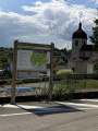
To return to the starting point in Thise, take the Chemin des Vaux. Continue straight on at the first junction, towards the riding centre, which you’ll leave on your right, until you reach a large clearing with a picnic table and an information board. Park here.
(S/E) Return along the road you took earlier to reach the junction with a footpath on the right leading out of the woods.
(1) Take this path and enter the forest, following the main track which soon turns westwards. Shortly after the pasture fence, head slightly to the right to reach a junction with a path crossing your route.
(2) Turn left onto this lovely path flanked by two dry-stone walls. Shortly afterwards, you’ll reach a white track which you follow to the right. As you come out of a right-hand bend, you’ll reach a crossroads with four paths.
(3) Ignore the paths on the right and left; continue straight ahead due north, following the direction indicated by the sign for the “Sentier des Dolines”. Further on, ignore the path on the left and you’ll reach a crossroads with a large stone bench.
(4) Turn right onto this beautiful path, which winds gently to avoid descending into the numerous sinkholes you’ll encounter. Walk for about 1.5 km until you reach the end of the path, where you’ll come to a junction with another track at a place called La Gruerie.
(5) Turn right and, a few metres further on, rejoin theGR®; follow it to the left until you reach a tarmac road. Follow this to the left and, about a hundred metres further on, you’ll find a forest track leading out towards a metal telephone pole, opposite a timber storage area.
(6) Turn right and enter the forest, following theGR® which then heads due east. Walk along the rocky ridge and you’ll reach a dirt track. Follow it for a few hundred metres until you come to a fork (elevation 346).
(7) Leave the white track and follow the path branching off to the right. Ignore all the paths leading off to the left or right and continue along a very beautiful, wide track until, much further on, you reach a road (D226A).
(8) Turn right onto it as it climbs and walk along the embankment; a path has been marked out for spectators of the famous Marchaux hill climb. Walk safely along the grassy embankment until, after the hairpin bend to the right, you reach a junction with a forest track crossing the path, at the sign for the Marchaux Communal Forest, where you’ll rejoin theGR® which you left a few steps earlier at the bend.
(9) Turn right onto this municipal boundary path. Further on, you’ll come to a clear junction with a path joining from the left.
(10) Take this path, which links up with the Chemin des Charbonnières, which you’ll reach shortly afterwards. Then keep to the right. You’ll then come to a junction with a white track.
(11) Carry straight on along the narrow path, ignoring the track on the left. Shortly afterwards, you’ll reach a junction.
(12) Ignore the path leading to the mast on the right, then the path that turns left, and carry on straight ahead. Continue until you rejoin the white track and theGR® further on; follow this by turning left. Further down, pass the hairpin bend and arrive at a junction of paths.
(13) Turn right and leave the white track, then turn right again a few metres further on. Carry on until you reach what is effectively a junction of six tracks (elevation 315).
(14) As the track ahead of you is impassable (rutted and flooded) due to forestry work, take the track running alongside it on the left, which forms the boundary between municipalities. Turn right at the first junction and, shortly afterwards, you’ll come to a crossroads with a logging track, marked with a mountain bike route sign.
(15) Take this track to the right and, immediately afterwards, turn left back onto the original track, which is in much better condition. Further on, you’ll come out onto a large turning area.
(16) Turn left onto the track along the edge of the woodland and head back to the car park (S/E).



 Visorando Member
 Easy
Easy