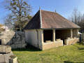
Esmoulins Circular Loop

A circular route starting from Gray, passing through the Hauts Bois State Forest to Esmoulins.
The return journey follows the old railway line to Velet, Essertey and then Gray-la-Ville.

Details

n°31322267
Creation:
Last update:
Last review:
  • Walking
    Activity: Walking
  • ↔
    Distance: 9.97 mi
  • ◔
    Average duration: 4h 45 
  • ▲
    Difficulty: Not specified

  • ⚐
    Back to start: Yes
  • ↗
    Ascent: + 200 ft
  • ↘
    Descent: - 197 ft

  • ▲
    Highest point: 764 ft
  • ▼
    Lowest point: 617 ft
  • ⚐ Country: France
  • ⚐ City: Gray (70100)
  • ⚑
    Start/End: N 47.441133° / E 5.590842°
  • ❏
    IGN map(s): Ref. 3222E, 3222O
  • Hour-by-hour weather

Photos

Description of the walk

Parking is available in the car park at Place des Tilleuls.

(S/E) Head south-east along the D21 towards Noiron for approximately 2.2 km. Pass the Gray stadium and the equestrian centre. About 100 m after entering the forest, you’ll reach a crossroads.

(1) Take the white path on the right for 600 m, then the dirt track on the left.

(2) At the end of this dirt track, follow the white track to the right for 400 m, then turn left onto a dirt track that runs almost in a straight line for about 1 km, crossing a white track and running alongside a pond. You will reach a wide cross-track.

(3) Turn right onto the white track and continue along the edge of the woodland until you reach the D475.

(4) Cross it carefully and carry on straight ahead along a dirt track until you reach a crossroads (elevation 202).

(5) Take the white track on the left until you reach a crossroad at the entrance to Esmoulins. Turn right onto this road and pass through Esmoulins following the D179. Pass the fountain and the wash house and reach the edge of the village.

(6) After the last house on the right, take the dirt track through the middle of the fields. At the crossroads, turn right onto this track and follow it for 200 m. Then turn left onto the dirt track and continue for about 100 m.

(7) Key point on the route: take the path on the left which leads into a wooded area. Follow this path (an old railway line) to the entrance to Velet.

(8) Then follow Rue des Acacias, then turn left onto Rue d’Apremont. At the Stop sign, turn right, then right again onto Rue Marquet. Next, turn left onto Rue des Vignes for 50 metres and right onto Rue des Juifs until you reach the D39.

(9) Turn right then left to cross the D39, then head opposite towards “Rives de Saône” via Rue des Prés until you reach the banks of the Saône and a cross-road. Follow this to the right for 200 metres.

(10) Leave the banks of the Saône and turn onto the dirt track on the right, crossing the fields to Essertey.

(11) Turn right and follow the D105. Pass in front of the Gray-la-Ville stadium. Then turn left onto Rue du Trouhot.

(12) At the junction, turn left onto Rue du Val de Saône and continue along Rue de Sonjour as far as the Sonjour sports hall.

(13) Follow the path to the roundabout. Then turn right onto the D475 towards Dole until you reach the next roundabout. Next, turn left onto Avenue Revon and head for Place des Tilleuls (S/E).

Waypoints

  1. S/E : mi 0 - alt. 719 ft - Place des Tilleuls
  2. 1 : mi 1.35 - alt. 735 ft - Crossroads in the forest
  3. 2 : mi 1.98 - alt. 705 ft - Junction onto a dirt track
  4. 3 : mi 2.87 - alt. 699 ft - Exit from the forest
  5. 4 : mi 3.49 - alt. 722 ft - D475
  6. 5 : mi 4.2 - alt. 659 ft - Crossroads
  7. 6 : mi 4.88 - alt. 679 ft - Path leading out of Esmoulins
  8. 7 : mi 5.39 - alt. 656 ft - Old railway line trail
  9. 8 : mi 6.14 - alt. 659 ft - Velet. Housing estate: Les Acacias
  10. 9 : mi 6.55 - alt. 630 ft - D39
  11. 10 : mi 7.3 - alt. 620 ft - Along the banks of the Saône, on the right
  12. 11 : mi 8.5 - alt. 623 ft - Essertey
  13. 12 : mi 9.03 - alt. 650 ft - Road junction
  14. 13 : mi 9.62 - alt. 725 ft - Roundabout
  15. S/E : mi 9.97 - alt. 719 ft - Place des Tilleuls

Notes

Avoid this route during the hunting season and in wet weather.

Reviews and comments

3.8 / 5
Based on 2 reviews

Reliability of the description
4 / 5
Ease of following the route
4 / 5
Route interest
3.5 / 5
Scan
Scan

Actually, I realised that last week.
Last year, this section was well maintained.

Machine-translated

Fée Néant
Fée Néant
• Edited:

Overall rating : 4 / 5

Date of your route : May 17, 2024
Reliability of the description : ★★★★☆ Good
Ease of following the route : ★★★★☆ Good
Route interest : ★★★★☆ Good
Very busy route : No

A lovely walk – note that, apart from a slight variation (returning via the banks of the Saône), the path is marked with a Green Circle. However, point 7 is indeed difficult to find; despite the Green Circle, I didn’t realise there was a path and carried on along the field before realising my mistake. I did the walk last Monday and, following a rainy spring and perhaps no (or very few) people having used the path for weeks, the track was barely visible and overgrown with tall grass, including stinging nettles. I don’t know what the path is like in summer, but I’d therefore advise against wearing shorts or Bermuda shorts on this walk.

Machine-translated

jpcassard
jpcassard

Overall rating : 3.7 / 5

Date of your route : Apr 12, 2023
Reliability of the description : ★★★★☆ Good
Ease of following the route : ★★★★☆ Good
Route interest : ★★★☆☆ Average
Very busy route : No

A pleasant route (forest, villages, town)

Machine-translated

Other walks in the area

For more walks, use our search engine .

The GPS track and description are the property of this route's author. Please do not copy them without permission.